
- Severe thunderstorms capable of large hail, damaging winds, and perhaps a couple of tornadoes are possible across parts of the southern Plains today.
- Strong winds today and Friday over the Four Corners States.
- Unsettled weather is expected to increase across the Northwest and northern Rockies with widespread showers and thunderstorms and high elevation mixed precipitation and snow forecast through the end of the week.
Delivered to your in-box each morning.
Starting Monday morning, 27 November, this site will be down for a major upgrade. RVWeather.com will return no later than Wednesday 29 November — sooner if possible. When the site returns, WILMA, our NEW(!) integrated weather impacts product, will be available. The Paywall will also be implemented. RV Weather will continue to provide free access to essential, RV-relevant National Weather Service Warnings and Advisories, current weather, and weather safety information. While the main site is off-line, I will post a simple forecast to my email list and to RVWeather on Facebook.
Click here for the extended outlook (updates every Tuesday, Thursday and Sunday evening).
From the RV Weather Summer Office in Moose Wyoming:
Pacific:
— North-central WA: Flood Watches for a combination of rain and snowmelt. US-97 potentially impacted.
— Eastern WA and northern ID: Isolated strong to severe thunderstorms may produce damaging winds and hail today. I-90, US-395 potentially impacted.
— Southeast WA and northeast OR: Flood Watches and Advisories in effect due to a combination of rain and snowmelt. US-195, I-84 potentially impacted.
— CA north-central Sierra Nevada. Snow Friday night through Saturday night. 5-12 inches possible at pass level. I-80, US-50 impacted.
— Southern CA Ventura, San Bernardino, San Gabriel County Mountains: Winter Weather Advisories above 6000 feet through this evening. 4-8 inches total snow accumulation. Wind gusts 40-55 mph.
— Southern CA Riverside and San Diego County Mountains. Wind Advisories through this evening. Gusts to 55 mph. I-8, I-10 impacted.
Mountain:
— Portions of north- and west-central, central and southeast ID: Flood Advisories and Watches due to snowmelt. I-15, I-90 potentially impacted.
— Northwest CO and adjacent south-central WY: Flood Watches for snowmelt. US-40 potentially impacted.
— Most of UT: Strong winds late this morning through this evening. Wind gusts 35-45 mph. I-15, I-70, I-80 impacted.
— Much of northern and central AZ: Wind Advisories mid-morning through this evening. Gusts to 45 mph. I-17, I-40 impacted.
— Eastern AZ; most of NM except southeast portion of state; south-central and east-central CO: Strong winds late Friday morning through Friday evening. Gusts 35-40 mph. I-10, I-19, I-25, I-40, I-70 impacted.
Central:
— South-central KS; central OK and central TX, along and west of the I-35 corridor: Severe thunderstorms capable of large hail, strong and damaging wind gusts, and a couple of tornadoes are possible this afternoon and evening. I-10, I-20, I-35, I-40, I-44 potentially impacted.
— Central TX along and north of the I-20 corridor: Strong winds this afternoon and evening. Gusts to 35 mph. I-20 impacted.
— North-central and northeast NE; western IA: Isolated strong to severe thunderstorms may produce damaging winds and hail today. I-35 potentially impacted.
— Much of western and central NE: Isolated strong to severe thunderstorms may produce damaging winds and hail Friday afternoon and evening. I-76, I-80 impacted.
— Central TX west of I-35 and bounded between I-10 and I-20: Slight risk of severe thunderstorms Friday afternoon and evening. Large hail and damaging winds likely the primary threats. I-10, I-20, I-35 potentially impacted.
— Eastern AR; southwest TN; eastern LA; most of MS: Isolated strong to severe thunderstorms may produce damaging winds and hail Friday afternoon and evening. I-10, I-12, I-20, I-22, I-40, I-55, I-59 potentially impacted.
— TN: Slight risk of Flash Flooding Friday and Friday night. Rainfall rates could reach 1.5 to 2 inches per hour with multiple lines of showers and thunderstorms. I-24, I-26, I-40, I-75, I-81 potentially impacted.
Eastern:
— Central and western MI Upper Peninsula: Flood Watch continues due to a combination of rainfall and snowmelt. US-2, US-41, MI-28 impacted.
— TN: Slight risk of Flash Flooding Friday and Friday night. Rainfall rates could reach 1.5 to 2 inches per hour with multiple lines of showers and thunderstorms. I-24, I-26, I-40, I-75, I-81 potentially impacted.


All the graphics (and more!) I used to attach to the daily forecast are now accessible with this link.
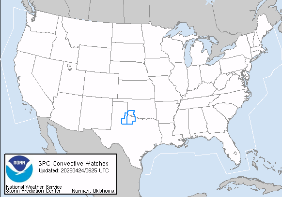
Current Severe Thunderstorm and Tornado Watches from the National Weather Service Storm Prediction Center
Tornado safety information for RVers (what to do!):
Access to real-time road information:
Phone numbers and websites for road conditions in all 50 states. Courtesy of the Cheyenne WY Weather Forecast Office
Some useful links:
Thank you for using RVWeather.