
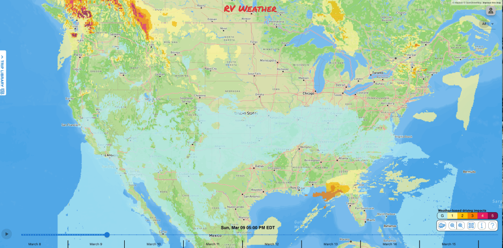
- Rain, showers and isolated severe thunderstorms this weekend from Dallas to northern Florida.
- Snow today across northern New Mexico and the Oklahoma and Texas Panhandles.
- Seasonably cold weather this weekend across the Northeast, with snow showers and strong winds for Upstate New York and interior New England.
From the RV Weather Field Office in State College PA:
These are the most significant weather impacts to RV travel over the next two to three days. I do not list every area of rain, showers, or breezy winds. It would be exhausting (for both of us!).
Looking for real-time road conditions? Here’s a link, courtesy of the Federal Highway Administration, to all the individual State 511 websites.
Weather Impacts Pacific Time Zone:
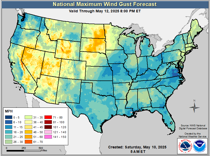
— North-central and southwest WA; northeast OR Blue Mountains; northern CA Siskiyou Mountains: Strong winds develop mid-morning Sunday and continue through Sunday evening. Wind gusts 30-40 mph. I-5, I-84, I-90, US-2, US-12, US-97 impacted.
— Western WA; northwest OR: Rain develops today across the WA Olympic Mountains and spreads to include all of western WA and northwest OR by Sunday. Rainfall amounts by 2-4 inches in the Olympics and northern WA Cascades by Monday morning. Less than an inch of rain at lower elevations. I-5, I-84, I-90, US,-2, US-101 impacted.
— Western WA Olympic and northern and central Cascade Mountains: Snow develops Sunday, then and continues for much of next week. 3-5 inches on Stevens Pass (US-2) and 1-2 inches on Snoqualmie Pass (I-90) Sunday evening. I-90, US-2 impacted.
Weather Impacts Mountain Time Zone:
— Most of northern and central MT along and east of the Rocky Mountain Front; south-central MT along I-90 east of Livingston: High Wind Watches Sunday and Monday. Wind gusts 60-65 mph except up to 80 mph along the Rocky Mountain Front. I-15, I-90, I-94, US-2, US-12, US-87, US-89 impacted.
— Southwest and south-central MT; northwest and west-central WY east of Yellowstone, including the Wind River Range; north-central WY Big Horn Range; parts of central and southeast WY: Strong winds develop Sunday and continue through Monday. Winds Sunday evening gust 30-45 mph. Strongest winds will be midday Monday. I-15, I-25, I-90, US-14, US-16, US-26, US-89, US-287 impacted.
— South-central and southeast CO; north-central, central , east-central and northeast NM: Winter Storm Warnings and Advisories continue this morning. Additional snow accumulations will range from 1-3 inches around Albuquerque to 3-6 inches in the mountains. I-25, I-40, US-54, US-56, US-64, US-84, US-285 impacted.
Weather Impacts Central Time Zone:
— Northwest SD: Strong winds early this afternoon. Wind gusts 30-35 mph. US-85 impacted.
— Western and southern ND; northern SD: Strong winds Sunday. Wind gusts 30-35 mph. I-29, I-94, US-2, US-12, US-52, US-83, US-85 impacted.
— Southwest KS; OK and TX Panhandles; western OK: Winter Storm Warnings and Advisories continue today and tonight. Addition snow accumulations 2-6 inches, with greatest amounts in the northwest TX and western OK Panhandles. I-27, I-40, US-54, US-56, US-60, US-64, US-83, US-287 impacted.
— Much of southern and southwest TX: Red Flag (fire danger) Warnings today. Wind gusts 25-35 mph. I-10, I-35, I-37, US-57, US-59, US-67, US-83, US-90, US-385 impacted.
— North-central and northeast TX; much of central and southeast OK; southwest AR; LA; southern MS; southern AL; FL Panhandle: Rain today and tonight. Up to an inch of rain across north-central TX and central and southern OK, and also the FL Panhandle. I-10, I-20, I-30, I-35, I-40, I-49, I-55, I-59, I-65 impacted.
— Much of north-central and eastern TX; southwest AR; LA; central and southern MS; southern AL; FL Panhandle: Isolated severe thunderstorms today and tonight. I-10, I-12, I-20, I-30, I-35, I-45, I-49, I-55, I-59, I-65, US-90 impacted.
— Southeast TX; central and southern LA; much of central and southern MS: Dense Fog Advisories early this morning. I-10, I-12 ,I-20, I-45, I-49, I-55, I-59 impacted.
Weather Impacts Eastern Time Zone:
— Western ME; northern NH: Wind Advisory late this morning through late this evening. Wind gusts to 50 mph. US-2, US-3, US-201 impacted.
— Central and east-central NY along the I-90 corridor from Utica to the MA border, including Albany; western MA: Wind Advisories through late this evening. Wind gusts to 50 mph. I-87, I-88, I-90, NY Thruway, Mass Pike impacted.
— Much of upstate NY; VT; western MA: Snow showers and snow squalls on Sunday. 2-4 inches in the Adirondack and Green Mountains; an inch or less of accumulation elsewhere. I-87, I-88, I-89, I-90, I-91, NY Thruway, Mass Pike impacted.
— Northeast, central and south-central PA; western MD; eastern WV; southwest VA; western NC: Strong winds through this evening. Wind gusts 30-40 mph with strongest winds on the higher terrain. I-26, I-40, I-64, I-68, I-70, I-76, I-77, I-80, I-81, I-84, I-99, PA Turnpike impacted.
— Southern GA and northern FL: Isolated strong to severe thunderstorms possible on Sunday. I-10, I-75, I-95 impacted.
Graphics for Today


Current Severe Thunderstorm and Tornado Watches from the Storm Prediction Center


Graphics for Tomorrow


Three-day Summaries


Access to real-time road information:
Phone numbers and websites for road conditions in all 50 states. Courtesy of the Cheyenne WY Weather Forecast Office
Some useful links:
Thank you for using RVWeather.