
- Widespread severe-weather moves through the Deep South this morning and spreads to much of the Mid-Atlantic and Southeast this afternoon and evening. Swaths of severe wind gusts and a few tornadoes are expected.
- Spring storm with heavy mountain snows and high winds impacts California, the Great Basin and the Four Corners States through Tuesday. Donner Pass (I-80) could see 4 or more feet of snow by Tuesday.
- High winds will create dangerous blowing dust conditions across much of eastern Arizona, New Mexico and western Texas on Tuesday.
- A second widespread severe weather outbreak will impact much of the Central and Eastern US Wednesday and Thursday.
From the RV Weather Mobile Command Center in Brunswick GA:
These are the most significant weather impacts to RV travel over the next two to three days. I do not list every area of rain, showers, or breezy winds. It would be exhausting (for both of us!).
Looking for real-time road conditions? Here’s a link, courtesy of the Federal Highway Administration, to all the individual State 511 websites.
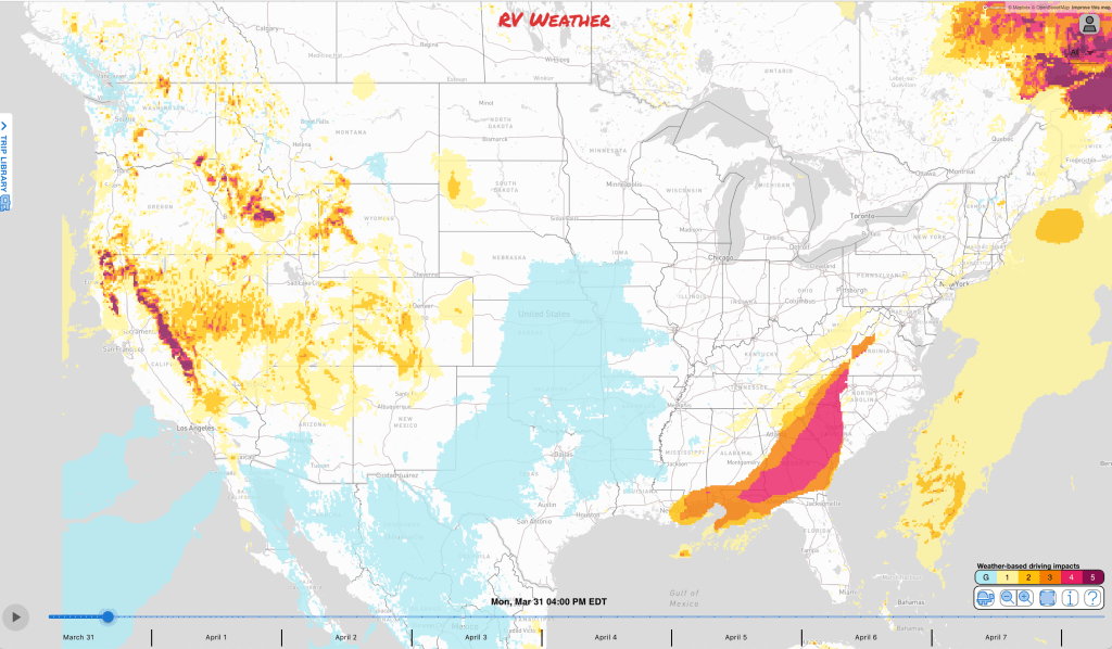
Weather Impacts Pacific Time Zone:
— South-central OR and northeast CA: Winter Weather Advisories early tonight through Tuesday evening. 3-6 inches of snow and wind gusts 30-45 mph. US-97, US-395 impacted.
— Northern CA above 4500 feet: Winter Storm Warning early tonight through Tuesday afternoon. 1-2 feet of snow and wind gusts to 45 mph. 3-7 inches of accumulation likely on Siskiyou Pass (I-5) tonight and Tuesday. I-5, US-97, US-395 impacted.
— Most all NV: Wind Advisories today and tonight. Gusts 50-55 mph. I-15, I-80, US-6, US-50, US-93, US-95 impacted.
— CA Sierra Nevada above 3500 feet: Winter Storm Warnings continue through early Tuesday night. 1-4 feet of snow and wind gusts 55-65 mph. 6-12 inches of snow between 3500-4000 feet. Heaviest snowfall expected today. Snow levels by late this evening may lower to 3000 feet. An additional 4-5 feet of snow expected over Donner Pass (I-80). I-80, US-50 impacted.
— Central CA eastern slopes of the southern Sierra Nevada; Owens Valley and Death Valley; southwest NV: High Wind Warning today and tonight. Wind gusts 55-65 mph. I-15, US-95, US-395 impacted.
— Southern CA Mojave Desert Slopes: High Wind Warning today through early Wednesday morning. Wind gusts to 65 mph. US-395, CA-14, CA-58 impacted.
— Much of the southern CA Deserts: Wind Advisories through Tuesday night. Wind gusts 50-55 mph. I-10, I-15, I-40, US-93, US-395, CA-58 impacted.
— Southern CA San Diego County Deserts: Wind Advisory continues through Tuesday night. Wind gusts to 60 mph. Strongest winds in the afternoons and evenings. I-8, CA-79 impacted.
Weather Impacts Mountain Time Zone:
— Central ID: Winter Weather Advisory today. 3-6 inches snow below 7000 feet and 6-12 inches at higher elevations.
— Portions of central, southwest and south-central MT; western WY and adjacent southeast ID; much of north-central and central UT: Winter Storm Warnings and Advisories through Tuesday night. Accumulations generally 4-8 inches in the valleys and at lower elevations and 6-12 inches across the higher passes. Some favored mountain locations could see up to 20 inches. Winter Weather Advisories continue through Wednesday in UT. I-15, I-70, I-80, I-90, US-6, US-12, US-14, US-16, US-20, US-26, US-30, US-40, Us-87, US-89, US-191, US-287 impacted.
— Southeast MT and north-central WY Big Horn Range: Winter Storm Watch Tuesday evening through Wednesday afternoon. 7-14 inches of snow probable. US-14 impacted.
— South-central WY and north-central, central and west-central CO: Winter Weather Advisories this evening through early Wednesday morning. 6-14 inches snow and wind gusts to 40-65 mph. I-70, US-24, US-40, US-50, US-285 impacted.
— Central and southern UT; northern, central and eastern AZ; western CO: Wind Advisories today and Tuesday. Wind gusts 45-55 mph. I-10, I-15, I-17, I-40, I-70, US-6, US-40, US-50, US-70, US-89, US-191 impacted.
— Central and eastern CO; northern and western NM: Strong winds today. Wind gusts 30-45 mph except gusts 45-60 across much of CO and north-central NM, including the Raton Pass (I-25). I-10, I-25, I-40, I-70, I-76, US-24, US-34, US-40, US-50, US-60, US-64, US-84, US-160 impacted.
— Southeast AZ: Red Flag (fire danger) Warnings Tuesday afternoon and evening. Wind gusts 45-50 mph. High chance of dangerous blowing dust conditions. I-10, I-19, US-70, US-191 impacted.
— South-central and southeast CO; much of NM; adjacent far-west TX: High Wind Watches Tuesday and Tuesday evening. Wind gusts to 65 mph. Expect areas of intense and dangerous blowing dust in portions of central and east-central NM, including I-25 and I-40. I-10, I-25, I-40, US-54, US-60, US-70, US-82, US-285, US-380 impacted.
Weather Impacts Central Time Zone:
— South-central and southeast ND; northeast SD; central and northern MN; northwest WI: Winter Storm Watches Tuesday afternoon through late Wednesday night. 5-9 inches snow likely. Wind gusts to 35 mph. I-35, I-94, US-2, US-52, US-53, US-71 impacted.
— Southwest KS; OK Panhandle; western TX: Red Flag (fire danger) Warnings Tuesday. Wind gusts 50-55 mph. I-10, I-20, I-27, I-40, US-50, US-62, US-64, US-70, US-84, US-87, US-90, US-270, US-380 impacted.
— Central and eastern NE, KS and OK; northern TX; western, central and northern MO; most of IA; northwest IL; southwest WI: Severe thunderstorms are expected to develop late Tuesday afternoon and continue throughout Tuesday night. Very large hail, severe wind gusts and a few tornadoes are all possible. I-20, I-35, I-39, I-40, I-44, I-55, I-70, I-72, I-74, I-80, I-88 potentially impacted.
— Northeast TX; eastern OK; northern LA; AR; central and eastern MO; southeast IA; southern WI; IL; KY; TN; central and northern MS; northern AL: A second widespread outbreak of severe weather is expected Wednesday and Wednesday night. Severe wind gusts, very large hail, and significant tornadoes are expected. I-20, I-22, I-24, I-30, I-35, I-39, I-40, I-41, I-44, I-45, I-49, I-55, I-75, I-69, I-64, I-70, I-72, I-74, I-80, I-88, I-90 potentially impacted.
— South-central and southeast LA; much of southern, central and eastern MS; central and northern AL: SEVERE THUNDERSTORM WATCHES this morning. Wind gusts to 70 mph, hail up to 2 inches in diameter, and a tornado or two are all possible. I-10, I-12, I-20, I-22 ,I-55, I-59, I-65, I-85 impacted.
— Southern AL; FL Panhandle: Strong and severe thunderstorms are expected on Monday. Strong to severe wind gusts and a few tornadoes are the primary hazards. I-10, I-65, I-85 impacted.
Weather Impacts Eastern Time Zone:
— Eastern PA; NJ; MD; DC; DE; VA; NC; SC; GA; FL Panhandle: Strong to severe thunderstorms today with swaths of severe wind gusts and perhaps a few tornadoes. Major highways along and east of the Appalachians from FL northwards to NJ potentially impacted.
— MI Lower Peninsula; IN; OH; most of KY and TN: A second widespread outbreak of severe weather is expected Wednesday and Wednesday night. Severe wind gusts, very large hail, and significant tornadoes are expected. I-22, I-24, I-40, I-64, I-65, I-69, I-70, I-71, I-74, I-75, I-76, I-77, I-80, I-90, I-94, I-96, OH Turnpike, IN Toll Road potentially impacted.
— Northern ME: Winter Weather Advisory continues through mid-morning. Freezing rain with a few hundredths of an inch of accumulation. I-95, US-1 impacted.
— Much of MA, RI, CT: Dense Fog Advisories this morning. I-84, I-90, I-91, I-95, Mass Pike impacted.
Graphics for Today


Current Severe Thunderstorm and Tornado Watches from the Storm Prediction Center


Graphics for Tomorrow


Three-day Summaries


Access to real-time road information:
Phone numbers and websites for road conditions in all 50 states. Courtesy of the Cheyenne WY Weather Forecast Office
Thank you for using RVWeather.