
- First in a series of winter storms brings high winds, heavy snows, and copious lower elevation rains to much of the Pacific Northwest, Northern California, the Intermountain West, and the northern Rockies.
- Strong to marginally severe thunderstorms possible this across southern Alabama and the Florida Panhandle.
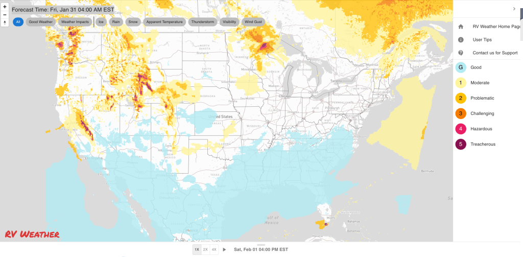
- Rain today and tonight for much of the East. 1/4 to 1 inch amounts will be common.
From the RV Weather Field Office in State College PA:
These are the most significant weather impacts to RV travel over the next two to three days. I do not list every area of rain, showers, or breezy winds. It would be exhausting (for both of us!).
Looking for real-time road conditions? Here’s a link, courtesy of the Federal Highway Administration, to all the individual State 511 websites.
Weather Impacts Pacific Time Zone:
— Coastal central and northern WA; west-central and northwest WA in the eastern Puget Sound Lowlands: Winter Storm Watch Saturday evening through Monday morning. 2-9 inches of snow possible. I-5, I-90, US-2, US-101 impacted.
— Southwest coastal WA; northwest coastal OR: Winter Storm Warnings this evening through Saturday evening. Up to 4 inches of snow expected. Snow levels start around 3000-4000 feet before lowering to less than 1000 feet by late Saturday morning. I-84, US-101 impacted.
— WA Cascade Mountains: Winter Storm Warnings above 3000 feet this evening through Saturday afternoon. 8 to 18 inches of snow possible. Wind gusts to 50 mph along exposed ridge tops. Snoqualmie Pass (I-90) will see snow this morning, rain this afternoon, then all snow again tonight through early next week. I-90, US-2, US-12 impacted.
— Central and eastern WA; north-central OR: Winter Weather Advisories through midday today. Snow, sleet and freezing rain this morning. Snow accumulation will range from less than an inch in the lower elevations to the south, to around 2 inches across the I-90 corridor, to 2-7 inches across northeast WA. I-82, I-84, I-90, US-2, US-12, US-97, US-195, US-395 impacted.
— Northern ID: Winter Storm Warning through Saturday morning. Snow. 4-9 inches in the valleys and 1-2 feet in the mountains. I-90, US-95 impacted.
— Southeast WA and northeast OR Blue Mountains: Winter Weather Advisory through Saturday afternoon above 4000 feet. 6-12 inches of snow possible. Wind gusts to 35 mph. I-84 impacted.
— Western WA; western OR; northern CA west of I-5: Heavy rain today and tonigh. Heavy rains continue across northern CA through Monday 1-4 inches of rainfall will be common, with higher amounts across northwest CA. I-5, I-84, US-101, CA-1 impacted.
— Much of OR east of I-5; northeast CA; CA Sierra Nevada Mountains: Strong winds today and tonight. Wind gusts 30-45 mph. I-84, US-12, US-20, US-26, US-95, US-97, US-395 impacted.
— OR Cascade Mountains: Winter Storm Warnings on the western side and Advisories on the eastern side above 3000 feet. 6-12 inches snow on the western side, with wind gusts to 50 mph. Snow levels start at 4000-5000 feet this morning, before lowering to 3000-3500 feet by tonight. US-20, US-26, US-97 impacted.
— East-central OR: Winter Weather Advisories today. 1-4 inches snow. I-84, US-26 impacted.
— The higher terrain of south-central OR; northern CA; northern NV above 3000-5000 feet: Winter Storm Warnings, Watches and Advisories through Saturday morning. In general, 2-8 inches of snow expected. Wind gusts 45-55 mph. Snow levels remain above the Siskiyou Pass (I-5) through Saturday night, but winds through the Pass may gust to 60 mph. I-5, US-97, US-395 impacted.
— Northeast NV Ruby Mountains: Winter Storm Watch this afternoon through late Sunday night. Up to 40 inches of snow possible. Wind gusts to 45 mph. This area is just south of I-80 and west of US-93.
— North-central CA I-5 corridor from Grenada south to Weed: High Wind Warning through Friday evening. Gusts to 60 mph. This includes Siskiyou Pass (I-5). I-5, US-97 impacted.
— Northwest CA coastal headlands: Wind Advisories through this afternoon. Gusts to 50 mph. US-101 impacted.
— Northern CA Sacramento Valley ; much of central CA north of the Monterey Bay: Flood Watches today through Sunday evening below 3000 feet. 2-4 inches of rainfall likely in many locations. I-5, I-80, US-101, CA-1, CA-99 impacted.
— CA Sierra Nevada Mountains: Winter Storm Warnings (south) and Advisories today through Saturday night. Snow levels around 6500 feet. 12-18 inches of snow in the north, and up to 3 feet of snow in the south. Wind gusts to 55 mph. 6-10 inches of snow possible across Donner Pass (I-80). I-80, US-50 impacted.
— West-central NV; adjacent east-central CA, east of the Sierra Nevada Mountains: High Wind Watches Sunday. Wind gusts 55-65 mph, with ridge-top wind gusts reaching 100 mph. I-80, US-6, US-95, US-395 impacted.
— Southern CA Eastern Sierra Slopes and Owens Valley: Wind Advisory late tonight through Sunday evening. Wind gusts to 50 mph. US-395 impacted.
— Southeast CA Mojave Desert: Wind Advisory Saturday and Saturday evening. Wind gusts to 45 mph. I-15, I-40, US-95, US-395, CA-58, CA-127 impacted.
Weather Impacts Mountain Time Zone:
— Much of northern and central ID; western and parts of central MT: Winter Storm Warnings (MT) Watches, and Advisories through late Tuesday night. By Monday, 10 inches to 2 feet of snow are possible with wind gusts up to 70 mph across northwest MT. The first storm will peak Friday night and Saturday. The second storm will bring heavy snows Sunday evening through Tuesday. Major impacts to the highways expected. I-90, US-2, US-12, US-93, US-95 impacted.
— Northwest MT Rocky Mountain Front: High Wind Warning late this evening through Saturday evening. Wind gusts to 60 mph. I-15, US-2, US-89 impacted.
— Parts of central and South-central MT including the Livingston area and Beartooth Foothills; parts of northwestern WY from Cody to the eastern boundary of Yellowstone National Park: High Wind Warnings, Watches and Advisories late this evening through late Saturday night. Wind gusts to 60 mph. I-15, I-90, US-14, US-26, US-89 impacted.
— South-central and southwest MT; southeast ID; much of western WY; north-central UT: Winter Storm Watches and Advisories (southwest MT) from late this morning through late Sunday evening. Heavy snow expected. 8-16 inches at lower elevations and 1-4 feet of snow in the higher elevations and at Pass level. Winter Storm Warnings continue through Monday evening in north-central UT. I-15, I-80, I-84, I-90, US-14, US-16, US-26, US-89, US-191, US-287 impacted.
— Much of central and southeast WY: High Wind Warnings and Watches this afternoon through Sunday morning. Wind gusts 60-70 mph. I-25, I-80, US-20, US-287 impacted.
— South-central WY; north-central CO: Winter Storm Watches late tonight through Sunday afternoon. 8-14 inches of snow and wind gusts to 60 mph. US-40 impacted.
— Much of central CO and north-central and east-central NM: Prolonged strong wind event starts tonight and continues well into next week. Winds initially peak Saturday afternoon. Wind gusts 30-50 mph. I-25, I-40, I-70, US-40, US-50, US-54, US-64 impacted.
Weather Impacts Central Time Zone:
— Central and eastern ND and SD; western and southern MN; northern IA: Strong winds tonight through Saturday afternoon. Wind gusts 30-35 mph. I-29, I-35, I-90, I-94 impacted.
— Northern and central MN; northern and central WI: Snow moves west to east Saturday and Saturday night. 2-6 inches likely. Heaviest accumulations across the MN Arrowhead and northern WI. I-29, I-35, I-43, I-94, US-8, US-10, US-41, US-51 impacted.
— Northeast MN along the Lake Superior Shoreline: Winter Storm Watch Saturday afternoon through late Saturday night. 5-8 inches of snow likely. Wind gusts to 35 mph. MN-61 impacted.
— Southeast IA; northeast MO; much of northern IL; northwest IN: Flood Watches through this afternoon. Up to 1.5 inches of rain falling on frozen ground and ice-covered rivers may create localized flash flooding. I-39, I-55, I-57, I-74, I-80, I88, I-90, IN Toll Road potentially impacted.
— Most of IL; northeast and east-central MO: Dense Fog Advisories this morning. I-39, I-44, I-49, I-55, I-57, I-64, I-70, I072, I-74, I-80, I-88 impacted.
— East-central OK; central and west-central AR: Dense Fog Advisories this morning. I-30, I-40, I-44 impacted.
— Southeast AL; FL Panhandle: Thunderstorms with isolated severe wind gusts will be possible this afternoon. I-10, I-65 potentially impacted.
Weather Impacts Eastern Time Zone:
— MI Upper Peninsula; MI northern Lower Peninsula: Snow Saturday night into Sunday morning. 3-6 inches on the UP and 2-4 inches on the Lower Peninsula. I-75, US-2, US-31, US-41 impacted.
— Northern OH; northwest PA; parts of Upstate NY and northern New England: Snow this evening and tonight. 1-4 inches accumulation expected. I-71, I-76,I-77, I-79, I-80, I-81, I-86, I-87, I-88, I-89, I-91, I-93, I-95, OH and Mass Turnpikes, NY Thruway impacted.
— Portions of north-central and northeast PA; northwest NJ; parts of central and southeast NY (north of New York City); western MA and CT: Winter Weather Advisories continue through early this afternoon. Freezing rain expected. A light glaze of ice possible. I-76, I-78, I-80, I-81, I-84, I-87, I-88, I-90, I-91, I-476, US-7, US-9, NY-17, NY Thruway, Mass and PA Turnpikes (Northeast Extension) impacted.
— Southwest PA; far-western MD; most of WV: Flood Watches through Saturday afternoon. A combination of snowmelt and around an inch of rainfall may produce localized flooding conditions. I-64, I-68, I-70, I-76, US-219, PA Turnpike potentially impacted.
— FL Panhandle; southwest GA: Thunderstorms with isolated severe wind gusts will be possible this afternoon. I-10 potentially impacted.
Graphics for Today


Current Severe Thunderstorm and Tornado Watches from the National Weather Service Storm Prediction Center


Graphics for Tomorrow


Three-day Summaries


Access to real-time road information:
Phone numbers and websites for road conditions in all 50 states. Courtesy of the Cheyenne WY Weather Forecast Office
Some useful links:
Thank you for using RVWeather.