
- Red Flag conditions continue this morning across Southern California. Rain and higher elevation snows arrive in Southern California this weekend.
- Winter snows and strong winds continue today for much of the northern and central Rockies.
- Snow for the California Sierra Nevada, the Great Basin, and northwest Arizona this weekend into early next week.
From the RV Weather Mobile Command Center in Brunswick GA:
These are the most significant weather impacts to RV travel over the next two to three days. I do not list every area of rain, showers, or breezy winds. It would be exhausting (for both of us!).
Looking for real-time road conditions? Here’s a link, courtesy of the Federal Highway Administration, to all the individual State 511 websites.
Weather Impacts Pacific Time Zone:
— Southwest OR: Freeze Watch tonight and Saturday morning, and again Saturday night and Sunday morning. Low temperatures in the upper 20’s deg F.
— South-central OR; northeast CA: Cold Weather Advisories this evening through Sunday morning. Wind chill values as low as -10 to -15 deg F.
— Southwest and south-central OR; northern CA: Wind Advisories late this evening through Saturday evening. Wind gusts to 45 mph. I-5, US-20, US-97, US-101, US-395 impacted.
— Northern CA Sacramento Valley and northern Sierra Nevada mountains: Wind Advisories this evening through Sunday morning. Wind gusts 45-55 mph. I-5, I-80, US-50, CA-36, CA-99, CA-299 impacted.
— Northeast NV: Strong winds Saturday. Wind gusts to 45 mph. I-80, US-95 impacted.
— Central CA central and southern Sierra Nevada Mountains: Winter Weather Advisories Saturday morning through Monday afternoon. 6 inches of snow expected, with up to a foot of snow above 8000 feet. CA-120, CA-140, CA-141 impacted.
— East-central and central NV: Snow tonight through Sunday afternoon. Snow accumulations will rain from 1-2 inches over the lower elevations to 6 inches or more in the Ruby Mountains. US-6, US-50, US-93, US-95 impacted.
— Southern CA Grapevine and Tehachapi, Mojave Desert Slopes above 3500 feet: Winter Weather Advisories Saturday afternoon through Monday afternoon. Up to 2 inches of snow above 3500 feet and up to 9 inches of snow above 4500 feet. I-5, CA-58 impacted.
— Portions of southwest NV and southeast CA: Winter Storm Watches Saturday morning through Monday evening. Up to 3 inches of snow above 3000 feet, 8 inches of snow from 3000-5000 feet, and 10-18 inches of snow above 7000 feet. I-15, I-40, US-6, US-95, US-395 impacted.
— Southern CA Santa Barbara, Ventura, Los Angeles County Mountains: Winter Weather Advisories Saturday afternoon through Monday afternoon. Snow. Accumulations will range up to 2 inches from 3500 – 4500 ft, 3-6 inches up to 6500 feet, and up to 10 inches at higher elevations. I-5, CA-14 impacted.
— Southern CA Riverside, San Bernardino, and San Diego County Mountains: Winter Storm Watches Sunday morning through Tuesday morning. 1-4 inches of snow possible above 3500 feet, 5-12 inches of snow up to 8000 feet, and nearly 2 feet of snow possible above 8000 feet. Wind gusts 45-55 mph. I-8, I-15, CA-138 impacted.
— Much of the coastal CA mountains from Santa Barbara County south to the Mexican Border, including Los Angeles and Ventura Counties. Red Flag (wildfire danger) Warnings continue through this morning. Wind gusts to 30 mph early this morning, then decreasing. I-5, I-8, I-10, I-15, US-101, CA-14 impacted.
— Southern CA: Rain develops Saturday afternoon and continues through Monday evening. Marginal risk of flash flooding, especially over recent burn scars. Up to an inch of rain is expected. I-5, I-8, I-10, I-15, US-101 impacted.
Weather Impacts Mountain Time Zone:
— Much of central and western MT: Winter Storm Warnings and Advisories today. Additional accumulations generally an inch or two, except 2-5 inches in the Lewis & Clark National Forest. Wind gusts to 35 mph. I-15, I-90, US-2, US-12, US-87, US-89, US-93, US-191 impacted.
— Portions of southeast ID: Extreme Cold Watch late Saturday night into Sunday morning. Wind chill values as low as -25 deg F.
— Southeast ID; much of western WY; north-central UT: Snow today. 3-7 inches at Pass Level and at the higher elevations. I-15, I-80, I-84, I-86, US-20, US-26, US-89 impacted.
— Portions of south-central and southeast WY: High Wind Warnings continue through midday today. Wind gusts 60-65 mph. I-25, I-80, US-287 impacted.
— Portions of south-central and southeast WY; parts of northwest and north-central CO: Winter Weather Advisories this afternoon though early Sunday morning. 2-6 inches of snow likely. Wind gusts to 40 mph. I-25, I-80, US-34, US-40. I-70 is just south of this advisory.
— Northeast and central UT, between I-70 and I-80: Snow tonight through Saturday evening. 3-6 inches accumulation likely, with higher amounts in the mountains. I-15, US-6, US-40, US-50, US-89 impacted.
— Portions of northeast and north-central CO: Snow tonight through Saturday evening: 3-6 inches of snow on the High Plains and over a foot of snow in the mountains. I-25, I-70, I-76, US-34, US-40, US-85 impacted.
— Central CO; north-central and east-central NM: Strong winds today. Wind gusts to 45 mph. I-25, I-40, I-70, US-40, US-50, US-54, US-60, US-64, US-70 impacted.
— West-central and northwest AZ: Winter Storm Watches Sunday evening through Tuesday morning. 2-5 inches of snow possible above 3500 feet and 5-8 inches of snow above 7000 feet. I-17, I-40, US-66, US-89 impacted.
— Southeast AZ; much of central and southern NM; southwest TX: Cold Weather Advisories continue this morning. Wind chill values generally +5 to +15 deg F, except below zero in the mountains.
Weather Impacts Central Time Zone:
— Central and eastern ND; northern and central MN: Snow moves from west to east today and this evening. Accumulations generally and inch or less in ND and 1-3 inches in MN. I-29, I-35, I-94 impacted.
— ND and SD; north-central and northeast NE; northwest IA; western MN: Strong winds today through Saturday. Wind gusts 30-45 mph. I-29, I-90, I-94, US-2, US-10, US-12, US-14, US-20, US-52, US-81, US-83 impacted.
Weather Impacts Eastern Time Zone:
— Western NY downwind of Lake Erie: Winter Weather Advisory through early this afternoon. An additional inch or so of snow accumulation. I-86, I-90, US-219, NY Thruway impacted.
— Western NY downwind of Lake Ontario: Lake Effect Snow Warnings and Winter Weather Advisories today and tonight. 5-10 inches of snow expected in the most persistent band. I-81, I-90, NY Thruway impacted.
— Eastern NC; southeast SC; much of southern and southeast GA; northern and central FL: A combination of Cold Weather Advisories, Freeze Watches and Warnings continue for the nighttime and morning hours through Saturday. Wind chills in the teens and temperatures falling to the lower 20’s. Black ice on roads and bridges from melting snow may create locally hazardous driving conditions each morning. This includes I-10, I-16, I-26, I-75, I-95, US-90.
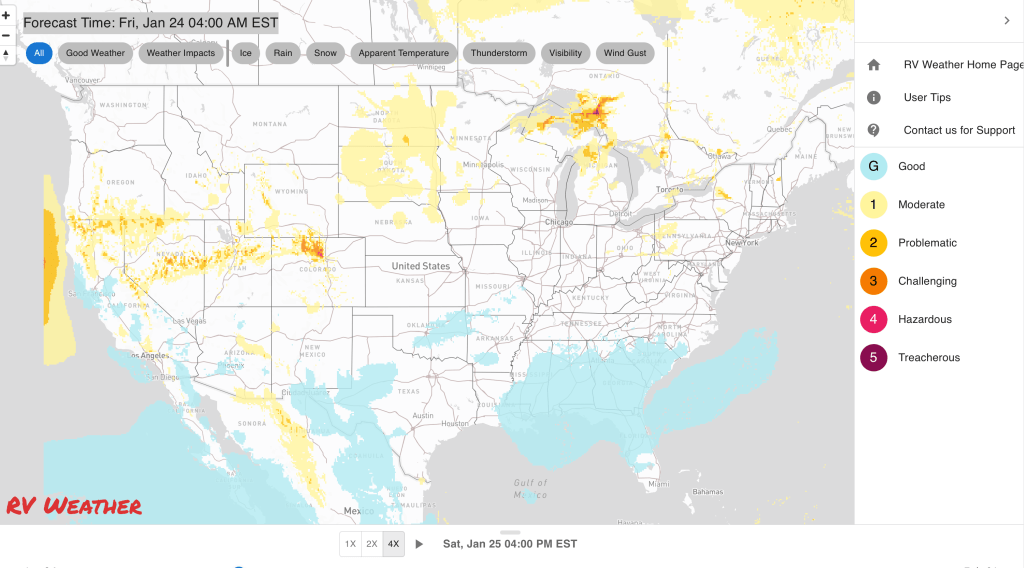
Graphics for Today


Current Severe Thunderstorm and Tornado Watches from the National Weather Service Storm Prediction Center


Graphics for Tomorrow


Three-day Summaries


Access to real-time road information:
Phone numbers and websites for road conditions in all 50 states. Courtesy of the Cheyenne WY Weather Forecast Office
Some useful links:
Thank you for using RVWeather.