
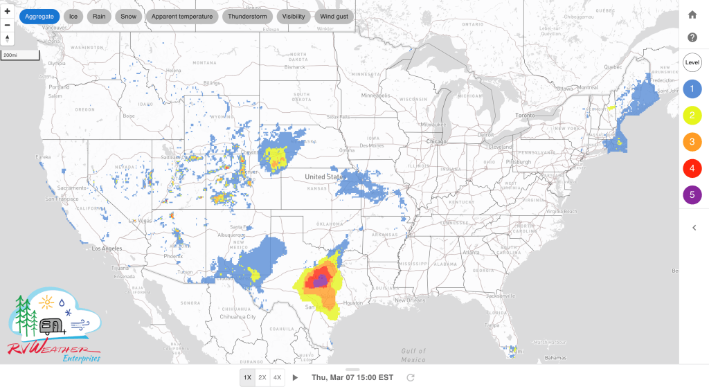
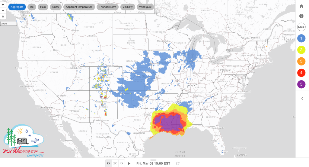
- Strong to severe thunderstorms, stretching from central Texas to the Southeast, expected daily through Saturday. Be aware of potential nighttime tornadoes Friday night across Louisiana, Mississippi and Alabama.
- Heavy rains with some flooding today and Friday across the central Mississippi Valley and the Deep South.
- Late winter storm for the Colorado Front Range and western Central Plains today and Friday.
- Strong winds today across I-10 over western Texas and southern New Mexico.
Delivered to your in-box each morning.
From the RV Weather Winter Office in State College, PA:
These are the most significant weather impacts to RV travel over the next two to three days. I do not list every area of rain, showers, or breezy winds. It would be exhausting (for both of us!). Please check out the animations and graphics (included) or WILMA for a good depiction of the weather along your route.
Weather Impacts Pacific Time Zone:
— Much of coastal CA north of Santa Barbara: Strong winds Thursday afternoon. Gusts to 30 mph. US-101, CA-1 impacted.
— Southern CA north of Los Angeles, including Tejon Pass / Grapevine: Strong winds today. Gusts 30-40 mph. I-5, CA-14, CA-58 impacted.
— CA southern Sierra Nevada Mountains; parts of central and east-central NV: Some light snow this afternoon and evening. A few inches in the mountains and a dusting to an inch or so in the deserts. US-6, US-50, US-93, US-395 impacted.
— Southern and southeast CA San Diego County Mountains and Deserts and Imperial Valley: Strong winds this evening and tonight. Wind gusts 30-40 mph. I-8 impacted.
Weather Impacts Mountain Time Zone:
— South-central and southeast WY; most of central CO along the Front Range; north-central NM: Winter Storm Warnings and Advisories Thursday and Friday. 5-11 inches of snow in the central and northern portions, decreasing to 3-6 inches over southern CO and northern NM. I-25, I-70, I-80, US-40, US-160 impacted.
— Northeast CO: Winter Storm Warnings and Advisories today and tonight. 2-7 inches of wet snow. Snow may mix with sleet and freezing rain. I-70, I-76 impacted.
— Much of east-central and southeast NM; portions of far-west TX: Red Flag (fire danger) this afternoon and evening. Wind gusts may reach 55 mph. I-10, I-20, I-40, US-60, US-70, US-84, US-180, US-285 impacted.
— Southeast NM and adjacent far-west TX: Wind Advisory late this morning through this evening. Wind gusts to 55 mph. US-180, US-285 impacted.
— Southeast NM and adjacent far-west TX Guadalupe and Delaware Mountains: High Wind Warning late this morning through midnight tonight. Wind gusts to 75 mph. US-180 impacted.
— Southwest and south-central NM: Strong winds late this morning through this evening. Gusts 35-45 mph. I-10, I-25 impacted.
Weather Impacts Central Time Zone:
— Much of central and western NE; northwest KS: Winter Storm Warnings and Advisories today and tonight. Snow, sleet and freezing rain may accumulate up to 4-8 inches over southwest NE, and 1-3 inches elsewhere. I-70, I-80, US-20, US-34, US-83 impacted.
— Central and eastern NE; western and central IA; much of KS; northwest MO; western OK; eastern TX Panhandle: Strong winds Friday. Wind gusts 30-35 mph. I-27, I-29, I-35, I-40, I-70, I-80 impacted.
— Much of western KS: Dense Fog Advisories this morning. I-70, US-50 impacted.
— South-central KS; much of central and west-central OK; much of central TX: Isolated to scattered severe thunderstorms should develop this afternoon and tonight. Large hail is the primary hazard, but occasional severe wind gusts and a tornado or two are also possible. I-10, I-20, I-30, I-35, I-40 potentially impacted.
— East-central and southeast OK; much of eastern TX; AR; LA; much of MS; central and southern AL; FL Panhandle: Severe thunderstorms capable of producing tornadoes, large hail, and damaging winds are expected to spread from west to east across this region Friday through Friday night. I-10, I-12, I-20, I-22, I-30, I-35, I-40, I-44, I-45, I-49, I-55, I-59, I-65 potentially impacted.
— Northeast LA; much of central MS: Dense Fog Advisories this morning. I-20, I-55, I-59 impacted.
— Much of central AL: Flood Watch Friday afternoon through Saturday afternoon. Up to 2-4 inches of rain expected. I-20, I-22, I-59, I-65, I-85 potentially impacted.
— Southeast AL; FL Panhandle: Scattered severe thunderstorms capable of producing both tornadoes and damaging winds are possible on Saturday. I-10, I-65, I-85 potentially impacted.
Weather Impacts Eastern Time Zone:
— Northeast ME: Snow, sleet and freezing rain tapers off this afternoon. 1-3 additional inches of accumulation with some ice. I-95, US-1 impacted.
— Southern ME and much of NH: Flood Warnings, Advisories and Watches through this evening. Up to 2 inches of rainfall expected. I-89, I-91, I-93, I-95 potentially impacted.
— Cape Cod MA: Wind Advisory this afternoon and tonight. Gusts to 50 mph expected. US-6 impacted.
— Portions of western NC; western SC; northeast GA: Dense Fog Advisories this morning. I-16, I-20, I-26, I-40, I-77, I-85 impacted.
— Southern NC; SC; most of GA; northern FL: Scattered severe thunderstorms capable of producing both tornadoes and damaging winds are possible on Saturday. I-10, I-16, I-20, I-26, I-40, I-75, I-77, I-85, I-95 potentially impacted.
— Much of northern and central GA: Flood Watches Friday evening through Saturday night. Up to 1-4 inches of rain expected. I-16, I-20, I-75, I-85 potentially impacted.
— FL Panhandle: Severe thunderstorms capable of producing tornadoes, large hail, and damaging winds are expected to spread from west to east across this region Friday through Friday night. I-10 potentially impacted.

Current Severe Thunderstorm and Tornado Watches from the National Weather Service Storm Prediction Center


Two-day tropical weather outlook from the National Hurricane Center

Access to real-time road information:
Phone numbers and websites for road conditions in all 50 states. Courtesy of the Cheyenne WY Weather Forecast Office
Some useful links:
Thank you for using RVWeather.