
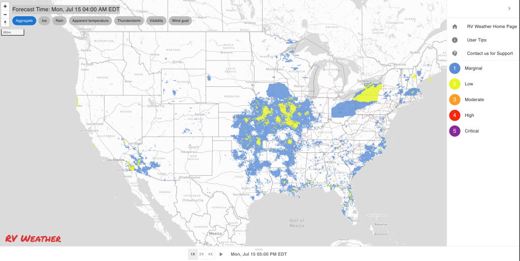
- Scattered strong to severe thunderstorms across the central High Plains, much of the Midwest, and into the Northeast. Greatest risk of severe weather is along the I-80 corridor from Des Moines Iowa to South Bend Indiana.
- More severe thunderstorms for Ohio and the Northeast on Tuesday.
- Hot and humid conditions throughout much of the Central and Eastern US south of I-80 today and Tuesday.
From the RV Weather Field Office in State College PA:
These are the most significant weather impacts to RV travel over the next two to three days. I do not list every area of rain, showers, or breezy winds. It would be exhausting (for both of us!).
Weather Impacts Pacific Time Zone:
— Southwest OR and northwest CA: Red Flag (fire danger) Warnings today for dry lighting strikes.
— Coastal northwest CA: Dense Fog Advisory this morning. US-101, CA-1 impacted.
Weather Impacts Mountain Time Zone:
— Parts of east-central and southeast ID: Red Flag (fire danger) Warnings today and tonight from thunderstorms with frequent lighting and erratic winds. Winds from thunderstorm outflows may gust to 50 mph. I-15, I-84, I-86, US-20, US-26, US-93 potentially impacted.
— Much of eastern WY; eastern CO; northeast NM: Isolated strong to severe thunderstorms are possible on Wednesday. I-25, I-40, I-70, I-76, I-80, I-90 potentially impacted.
— Southeast WY; northeast CO: Severe thunderstorms possible this afternoon and evening. Primary hazard will be strong wind gusts. I-76, I-80 potentially impacted.
— Eastern CO: Strong to severe thunderstorms are possible on Tuesday. Wind gusts and hail will be the primary hazards. I-70, I-76, US-6, US-34, US-36, US-40, US-50, US-160, US-287 potentially impacted.
— Portions of east-central and southeast CO: Heat Advisory today. High temperatures 94-101 deg F.
— Portions of northwest and central NM, including Albuquerque: Heat Advisories today. High temperatures may reach 101 deg F.
— Southeast AZ: Isolated severe thunderstorms with wind gusts are possible today. Thunderstorm outflow winds may create localized dust storms. I-10, I-19 potentially impacted.
Weather Impacts Central Time Zone:
— Southeast MN; IA; central and southern WI; northern and central IL: Strong to severe thunderstorms expected this afternoon and evening. A few tornadoes and severe, damaging winds are the primary hazards, especially along the I-80 corridor from Des Moines IA to South Bend IN. I-35, I-39, I-41, I-43, I-55, I-57, I-74, I-80, I-88, I-90, I-94 potentially impacted.
— Western NE: Severe thunderstorms expected this afternoon and evening. Wind gusts are the primary hazard. I-80 potentially impacted.
— Southern and eastern NE; central and southern IA; IL; KS; MO; western KY and TN; AR; northern TX; northern LA; western, central and southern MS; central and southern AL; western FL Panhandle: Heat Advisories today. Heat index values generally between 105-112 deg F.
— Southwest NE; western KS; OK Panhandle: Strong to severe thunderstorms possible on Tuesday. Wind gusts and hail are the primary hazards. I-70, I-80, US-50, US-64, US-64, US-83 potentially impacted.
— Western NE; far-western KS; western OK Panhandle: Isolated strong to severe thunderstorms possible on Wednesday. I-70, I-80, US-20, US-50, US-64 potentially impacted.
Weather Impacts Eastern Time Zone:
— Central and northern IN; southwest MI: Strong to severe thunderstorms expected this afternoon and evening. A few tornadoes and severe, damaging winds are the primary hazards, especially along the I-80 corridor from Des Moines IA to South Bend IN, and the I-65 corridor from Indianapolis to Chicago. I-65, I-69, I-70, I-74, I-80, I-90, I-94, I-96, I-196, IN Toll Road potentially impacted.
— Southeast ME; much of eastern and southern NH; central and western MA; RI; CT; lower elevations of central and eastern NY; most of central and eastern PA; NJ; most of MD; DC; DE; northern and eastern VA; southwest WV; central and eastern NC; central and eastern SC; coastal GA and coastal northeast FL; southern FL: Excessive Heat Warnings, Watches and Heat Advisories today and Tuesday. Heat Index values will range from the lower 100’s in New England to as high as 115 deg F in the Southeast.
— Parts of northern, central and western NY; central and northeast PA: Severe thunderstorms expected this afternoon and evening. Wind gusts are the primary hazard. I-80, I-81, I-86, I-88, I-90, NY Thruway potentially impacted.
—Northern, central and western NY; much of northern, central and western PA; central and eastern OH; northwest WV: Strong to severe thunderstorms are possible on Tuesday. A tornado or two, wind gusts and hail are all possible. I-70, I-71, I-74, I-75, I-76, I-77, I-79, I-80, I-81, I-86, I-87, I-88, I-90, I-99, NY Thruway, OH and PA Turnpikes potentially impacted.
— Most of ME; NH; VT; MA; CT; RI; central and eastern NY; central and eastern PA; NJ; most of MD; DC; DE; northern VA: Isolated strong to severe thunderstorms possible on Wednesday. I-66, I-68, I-70, I-76, I-78, I-80, I-81, I-83, I-84, I-86, I-87, I-88, I-89, I-90, I-91, I-93, I-95, I-99, NY Thruway, Mass, PA, NJ Turnpikes, Garden State Parkway potentially impacted.
Graphics for Today


Current Severe Thunderstorm and Tornado Watches from the National Weather Service Storm Prediction Center


Graphics for Tomorrow


Three-day Summaries


Access to real-time road information:
Phone numbers and websites for road conditions in all 50 states. Courtesy of the Cheyenne WY Weather Forecast Office
Some useful links:
Thank you for using RVWeather.