
** Heads Up ** Hurricane Milton is expected to make landfall as a Category III or IV hurricane along the central west-coast of Florida late on Wednesday. RV and all other interests along the west coast and central Florida should be prepared for hurricane force winds and destructive storm surge from Ft. Myer northward to the Suwannee River. This includes Tampa Bay where the storm surge may reach 15 feet. Wind gusts to hurricane force can be expected across much of the central FL Peninsula and as far northeast as St. Augustine. The east-central and northeast coasts of Florida may also experience hurricane conditions, flooding rains, and storm surges up to 5 feet. If you are directed or decide to evacuate, north of I-10 and west of I-75, ideally west of Tallahassee, will be a safe place for evacuation. As always, please follow the directions and guidance from your local Emergency Management officials.
- Heatwave eases for much of California and the desert Southwest.
- Rain showers mixed with snow on the highest peaks for upstate New York and western New England late Wednesday.
- Much of the country enjoying dry and seasonably warm weather for early October.
From the RV Weather Mobile Command Center at the Airstream International Rally in Sedalia MO:
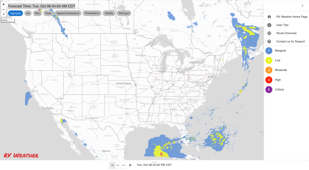
These are the most significant weather impacts to RV travel over the next two to three days. I do not list every area of rain, showers, or breezy winds. It would be exhausting (for both of us!).
Weather Impacts Pacific Time Zone:
— Western WA: Periods of light rain and rain showers today and Wednesday. Some snow on the highest peaks of the Olympic and Cascade Mountains. I-5, I-90, US-101 impacted.
— Central CA East Bay area: Heat Advisory today. High temperatures in the mid to upper 90’s.
— Southern CA Coachella and San Diego County Deserts: Excessive Heat Warning today. High temperatures 106-110 deg F.
— Southern CA Coastline in Orange and San Diego Counties: Dense Fog Advisory this morning. I-5 impacted.
Weather Impacts Mountain Time Zone:
— Northwest MT Rocky Mountain Front including east Glacier NP: Strong winds this afternoon. Wind gusts to 35 mph. Strong winds return late Wednesday afternoon and evening. US-2 impacted.
— Portions of southeast WY: Red Flag Warnings this afternoon and evening. Wind gusts to 30 mph. I-25, I-80 impacted.
— A portion of west-central AZ: Excessive Heat Warning today. High temperatures 104-108 deg F.
Weather Impacts Central Time Zone:
— No significant weather impacts to RV Travel today or Wednesday.
Weather Impacts Eastern Time Zone:
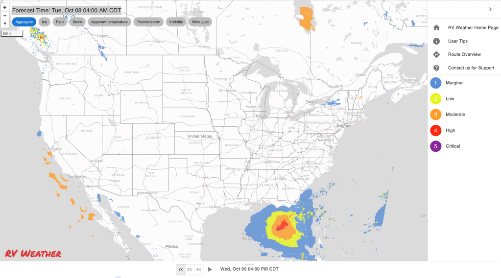
— FL Peninsula: Hurricane Milton is 550 miles southwest of Tampa this morning, with winds of 155 mph. The storm is expected to remain a major hurricane as it grows in size and accelerates to the northeast. Milton will make landfall on the central west coast of FL on Wednesday evening, likely as a Category III or IV hurricane. Milton’s storm surge could reach 15-20 feet in Tampa Bay.
— A storm surge of 3 feet or more is expected as far north as the Suwannee River and as far south as the Everglades. Destructive and deadly storm surges of10-15 feet and 6-10 feet are forecast for Tampa Bay and Charlotte Harbor, respectively. Much of northeast FL and the southern GA coast will experience a storm surge of 3-5 feet and 2-4 feet through much of the St. John’s River basin.
— Destructive winds are expected along the FL west coast from the Suwannee River southward to Ft. Myer. Much of central FL will see destructive winds. Wind along the east-central FL coast centered around Cape Canaveral may also reach hurricane force.
— Much of central and north-central FL will see 4-12 inches of rainfall, falling on already saturated ground. The most significant freshwater flooding will be north of a line from Ft. Myers to Vero Beach in the south, and south of a line from the Suwannee River to Jacksonville in the north.
— For RVer’s: Firstly, if you are camping or located anywhere along the immediate west coast of FL, south of the Big Bend region, you need to move out of harms way. If you are along the east coast of FL north of Vero Beach, you need to evacuate or find a safe shelter away from storm surge, fresh water flooding, or winds gusting to hurricane force. If you are inland in central or northeast FL, you should move your RV to high ground to avoid flooding and seek shelter in a sturdy building to protect yourself from destructive winds.
— Recommended evacuation locations: If you are directed or decide to evacuate, north of I-10 and west of I-75, ideally west of Tallahassee, will be a safe place for evacuation. If you are south and east of Tampa, an alternative evacuation location would be to southeast FL. While they will likely see tropical storm force wind gusts and isolated tornadoes, they have infrastructure to support your evacuation. As always, please follow the directions and guidance from your local Emergency Management officials.
— Hurricane Warning are issues from encompass much of the west coast of Florida from the Suwannee River southward to Ft Myers. Hurricane Warnings extend inland and include much of central FL. Storm Surge Warnings have been issued for the FL West Coast from the Suwannee River to the Everglades. Storm Surge Watches extend from south of Charleston SC to east-central FL coast. Hurricane Watches extend from Jacksonville to Vero Beach on the East Coast. Tropical Storm Watches are in effect for much of coastal SC and coastal GA, as well as southeast FL.
— Much of central and southern FL Peninsula: Isolated tornadoes may develop later today and continue through Thursday, associated with Milton.
— North Carolina, interior South Carolina, central and northern Georgia will not be impacted by Hurricane Milton.
Graphics for Today


Current Severe Thunderstorm and Tornado Watches from the National Weather Service Storm Prediction Center


Graphics for Tomorrow


Three-day Summaries


Access to real-time road information:
Phone numbers and websites for road conditions in all 50 states. Courtesy of the Cheyenne WY Weather Forecast Office
Some useful links:
Thank you for using RVWeather.