


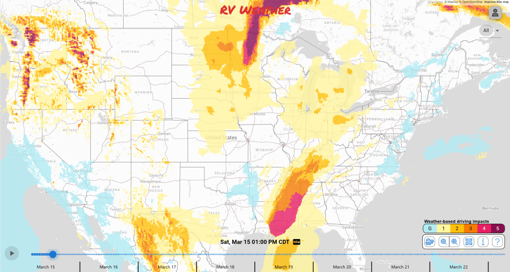
- Widespread severe weather outbreak expected in the Southeast Saturday into the Mid Atlantic for Sunday. Some significant tornadoes, damaging winds, and large hail expected.
- Snow and blizzard conditions are expected in the upper Plains today.
- Gusty winds expected today for a lot of regions between the Plains and the Appalachians.
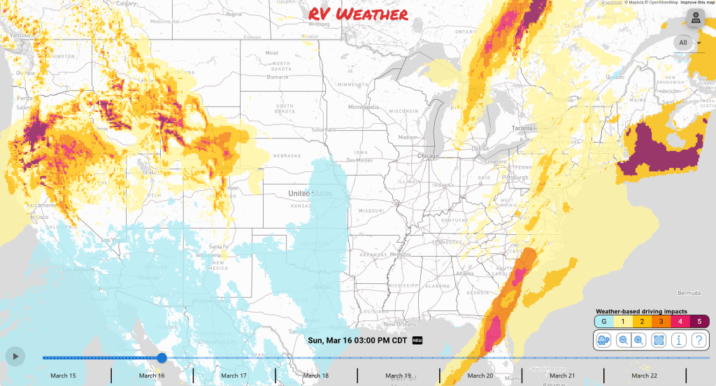
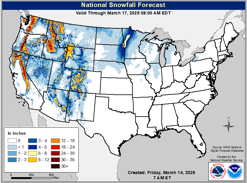
- Some mountain snow continues in the west as another storm system moves through this weekend.
From the RV Weather Field Office in Philadelphia, PA:
These are the most significant weather impacts to RV travel over the next two to three days. I do not list every area of rain, showers, or breezy winds. It would be exhausting (for both of us!).
Looking for real-time road conditions? Here’s a link, courtesy of the Federal Highway Administration, to all the individual State 511 websites.
Weather Impacts Pacific Time Zone:
— Northern WA Cascades: Winter Storm Warning in effect through Sunday morning. Additional snowfall of 12 – 18 inches of snow above 2000 feet. Snoqualmie Pass of I-90, Stevens Pass of US-2, US-12 impacted.
– Southern WA and OR Cascades: Winter Storm Warning in effect until Sunday evening. Additional snowfall of 2 – 3 feet expected with wind gusts up to 45 – 60 mph. US-20, US-26, US-97, US-395 impacted.
– Southeast WA and northeast OR Blue Mountains: Winter Weather Advisory in effect through Sunday morning. Snowfall of 10 – 20 inches expected above 4000 feet, a few inches in lower elevations. I-84 impacted.
– CA Sierras: A mix of Winter Weather Advisories, Winter Storm Watches and Winter Storm Warnings are in effect this afternoon through Monday. Snow accumulations of up to 1 – 2 feet expected with winds gusting as high as 70 – 80 mph. I-5, I-80, US-50, US-97, CA-299 impacted.
— Coastal OR and northwest CA: Heavy rain will fall through Sunday afternoon. Heavy rainfall amounts of 3 – 6 inches of rain will fall making a risk of flooding. I-5, US-20, US-101, CA-299, OR-238 impacted.
— Southeast WA; much of OR; northern CA; northwest NV: A combination of Wind Advisories, High Wind Watches and High Wind Warnings are issued for this afternoon through Sunday. Wind gusts up to 45 – 70 mph. Higher in higher elevations. I-5, I-80, I-84, US-12, US-20, US-26, US-50, US-95, US-97, US-395, CA-299 impacted.
Weather Impacts Mountain Time Zone:
— Northwestern MT and northern ID; Lewis Range and Cabinet Mountains: Winter Weather Advisory is in effect until midday today. Up to 6 inches of snowfall expected. I-90, US-2, US-93 impacted.
— Central ID; Smokey, Pioneer, and Centennial Mountains: Winter Weather Advisories and Winter Storm Warings are in effect tonight through Sunday. Snowfall accumulations of 4 – 12 inches in lower elevations and 1 – 2 feet above 7000 feet. Gusty winds of 45 mph expected. US-20, US-95 impacted.
— Southeast ID and central UT; Wasatch and Central Mountains: Winter Weather Advisory in effect into tonight. Snow accumulations of 3 – 8 inches expected. I-15, I-70, I-80, I-84, US-6, US-50, US-89, US-91, US-189 impacted.
— Mountains of western NM and eastern AZ and Sacramento Mountains in NM: Winter Weather Advisories in effect through midday today. Additional snow accumulations of up to 3 inches expected. I-40, US-60, US-70, US-82, US-180, US-191 impacted.
— Southwest ID: Wind Advisory in effect midday today through Sunday evening. Wind gusts up to 50 mph expected. US-93, US-95 impacted.
— Absaroka/Beartooth Mountains and Crazy Mountains of southern MT: Winter Storm Watch in effect throughout Sunday. Snow totals of 8 – 12 inches and gusty winds 60 -75 mph expected. US-212 impacted.
— Southern MT and much of WY: High Wind Warings and Watches are in effect late tonight throughout Sunday. Wind gusts up to 70 mph expected. I-15, I-25, I-80, I-90, US-12, US-14, US-16, US-20, US-30, US-85, US-89, US-191, US-212, US-287 impacted.
— Southeast NM and western TX: Wind Advisories and High Wind Warnings are in effect throughout this evening. Wind gusts of 50 to 70 mph expected. I-10, I-20, US-62, US-67, US-82, US-90, US-285, US-385 impacted.
Weather Impacts Central Time Zone:
– ND; SD; MN; northwest IA northeast NE: Wind Advisories and High Wind Warnings in effect through this evening. Wind gusts up to 50-60 mph expected. I-29, I-80, I-90, I-94, US-2, US-12, US-14, US-30, US-75, US-83, US-85, US-281 impacted.
— Central TX: Wind Advisory in effect this morning through this evening. Wind gusts up to 45 mph expected. I-10, I-35, I-37, US-57, US-67, US-83, US-87, US-90, US-281, US-290, US-277, US-377 impacted.
– Eastern ND and SD into western MN, northeast NE, northwest IA: A combination of Winter Weather Advisories, Winter Storm Warnings and Blizzard Warnings are in effect through this evening. Visibility less than 1/4 mile, snowfall accumulations up to 6 inches, and winds up to 60 mph expected. I-29, I-90, I-94, US-12, US-14, US-18, US-20, US-59, US-75, US-81, US-212 impacted.
— Southern LA, southern MS, AL, FL Panhandle, western TN: Wind Advisories in effect through this evening. Wind gusts up to 35 to 45 mph expected. I-10, I-12, I-20, I-22, I-49, I-55, I-59, I-65, I-85 impacted.
— Much of IL, eastern: Wind Advisories and High Wind Warnings in effect through this evening. Wind gusts up to 45 to 60 mph. I-39, I-41, I-43, I-55, I-57, I-70, I-74, I-80, I-88, I-90, I-94, US-10, US-12, US-24, US-41, US-45 impacted.
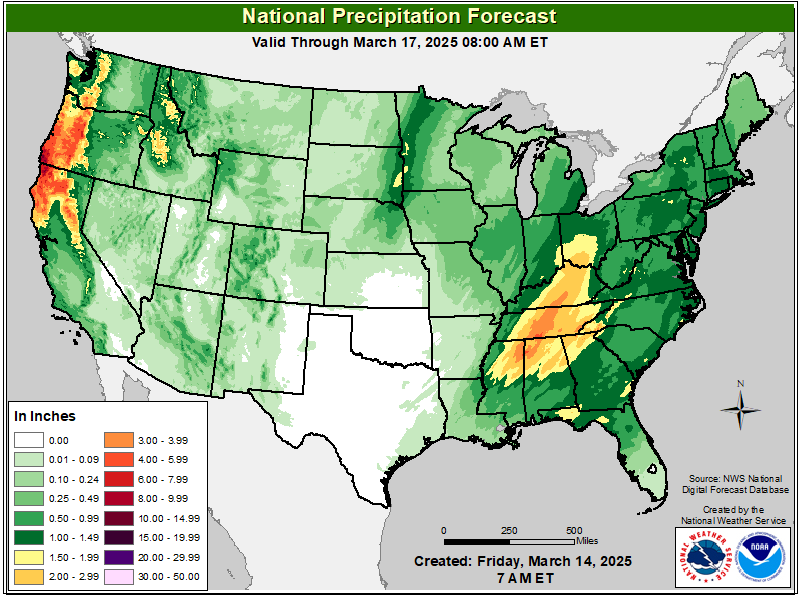
— Northern AL central TN: Flood Watch in effect through tonight. Heavy rains from thunderstorms today will leave an elevated risk of flash flooding. I-22, I-40, I-59, I-65, US-45, US-64, US-72, US-79 impacted.
— Eastern TX: Severe thunderstorm Watch in effect through this morning. Watch for Severe thunderstorms to produce scattered large hail and isolated very large hail events to 2.5 inches in diameter possible, scattered damaging wind gusts to 70 mph possible and a tornado or two possible. I-20, I-45, US-59, US-69, US-79, US-287 impacted.
— Northern LA, northern MS, northern AL, central TN: Tornado Watches in effect through midday today. Severe thunderstorms could bring a few tornadoes and a couple intense tornadoes likely, scattered damaging winds and isolated significant gusts to 75 mph likely and scattered large hail and isolated very large hail events to 2.5 inches in diameter likely. I-20, I-22, I-24, I-40, I-55, I-65, US-45, US-61 impacted.
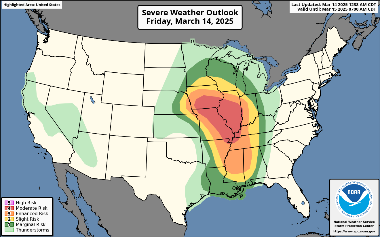
– LA, MS, AL, TN, KY, eastern AR: Widespread severe weather expected throughout the day today and overnight. Significant tornadoes, damaging winds and large hail expected. I-10, I-20, I-24, I-40, I-45, I-49, I-55, I-59, I-65,
Weather Impacts Eastern Time Zone:
– IN, MI and much of OH: High Wind Warnings and Wind Advisories in effect through this evening. Wind gusts up to 50 – 60 mph expected. I-24, I-64, I-65, I-69, I-71, I-74, I-75, I-80, I-90, I-94, I-96, US-2, US-24, US-27, US-30 US-131 impacted.
– Southeast MI, eastern IN, OH, western PA, WV: Some severe weather possible today into tonight. Some tornadoes, damaging winds and large hail possible. I-64, I-65, I-69, I-71, I-75, I-77, I-79, I-80, I-90, I-94, I-96 impacted.
— GA, western NC, eastern TN, KY, western VA; Wind Advisories in effect through tonight. Wind gusts up to 45 – 55 mph expected. I-20, I-24, I-26, I-40, I-64, I-75, I-81, I-85 impacted.
– Eastern TN, KY, western SC, western NC and western GA: Widespread severe weather expected throughout the day today and tonight. Significant tornadoes, strong damaging winds and large hail expected. I-10, I-20, I-24, I-26, I-40, I-64, I-75, I-85 impacted.
— Northern PA, eastern NY: Wind Advisories in effect late tonight through Sunday. Wind gusts up to 50 mph expected. I-79, I-81, I-86, I-90, US-11 impacted.
— North FL, eastern GA, SC, NC, VA, WV, MD, PA, DE, southern NJ: Severe thunderstorms are possible Sunday. A few tornadoes, some large hail, and damaging winds are possible. I-10, I-16, I-20, I-26, I-40, I-64, I-66, I-70, I-75, I-76, I-81, I-85, I-95 impacted.
Graphics for Today


Current Severe Thunderstorm and Tornado Watches from the Storm Prediction Center


Graphics for Tomorrow


Three-day Summaries


Access to real-time road information:
Phone numbers and websites for road conditions in all 50 states. Courtesy of the Cheyenne WY Weather Forecast Office
Some useful links:
Thank you for using RVWeather.