


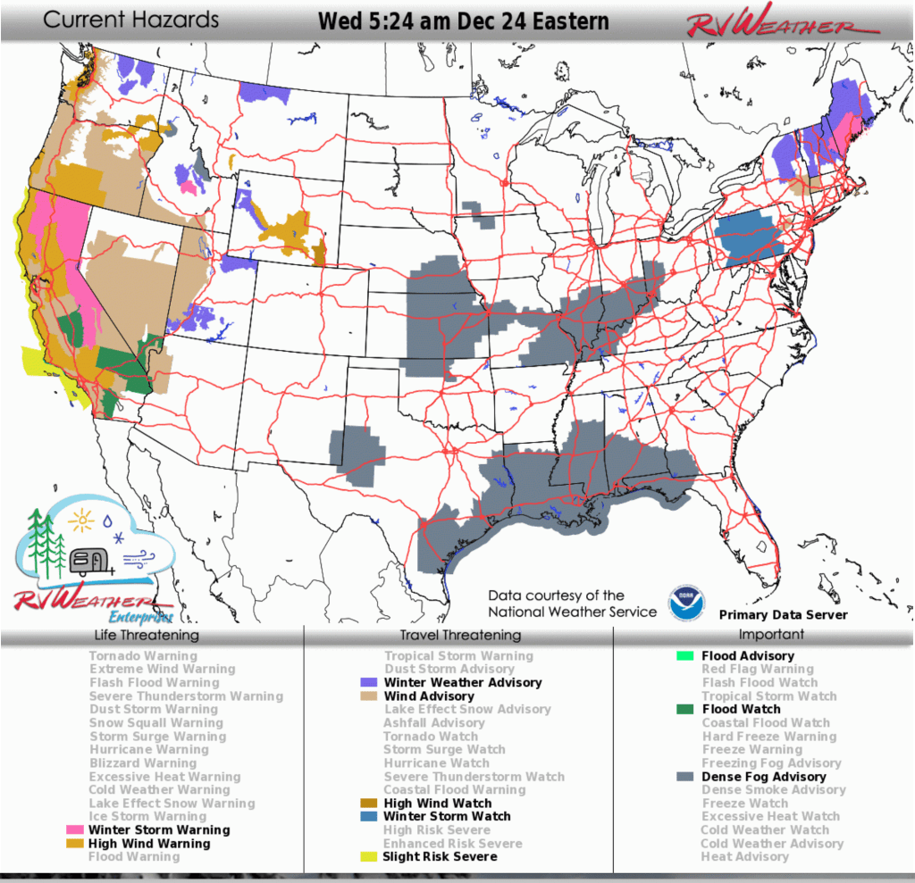
- Flood Watches: Dangerous flash flooding from heavy rain may inundate roadways and low-lying areas across almost all of California, southern and southwest Nevada, and northwest and west-central Arizona through Friday, with the highest risk across southern California today and Thursday.
- Winter Storm Warnings: Heavy snow with very difficult mountain travel is expected across much of northern California and the Sierra Nevada Mountains this afternoon through Friday evening.
- High Wind Warnings and Advisories: Strong to damaging winds may create hazardous travel for high-profile vehicles across the Pacific Northwest, California, and parts of the Great Basin today and continuing through Thursday afternoon.
From the RV Weather Field Office in State College PA:
Here are the relevant National Weather Service Warnings, Watches and Advisories that will impact RV and Road travel over the next several days.
Scroll down to the always-updating graphics immediately below this forecast for the latest information and for weather impacts that do not meet NWS Alert criteria.
RV Weather’s free Weather Hub has a complete collection of always updating forecasts.
Note: The daily written forecast will transition to a weekly RV Weather Outlook beginning in January 2026. Continuously updated (free) graphics will continue.
“Love the forecast? Now plan your safest route.” RV Weather’s daily forecasts keep you informed — but our SureRoute subscription gives you personalized, RV-safe routes that avoid dangerous weather and delays.
Weather Impacts Pacific Time Zone:
— Western WA and northwest OR along the I-5 corridor and Puget Sound: High Wind Warnings and Advisories today. Wind gusts 45-60 mph. I-5, I-84, I-90, US-2, US-12, US-30, US-101 impacted.
— North-central WA: Winter Weather Advisories continue through this afternoon. 2-5 inches snow expected. US-2, WA-20 impacted.
— South-central WA: Wind Advisory today. Wind gusts to 50 mph. US-97 impacted.
— Southeast WA and northeast OR Blue Mountains and Foothills: High Wind Warnings (foothills) through this afternoon. Wind gusts will range from 45 mph in the Mountains to 65 mph across the Foothills. I-84, US-12, US-395 impacted.
— Much of western OR west of the Cascades, including the south OR Coast: High Wind Warnings (coastal) and Advisories through this afternoon. Wind gusts 45-55 mph in the interior and up to 65 mph along the coast. I-5, I-84, US-20, US-26, US-101 impacted.
— OR east of the Cascades; southern OR Cascades: High Wind Warnings and Advisories through this afternoon. Wind gusts 50-70 mph. Strongest winds across south-central OR. I-5, I-84, US-20, US-26, US-95, US-97, US-395 impacted.
— Much of northern and northeast CA: Winter Storm Warnings this afternoon through Friday evening. Heavy snow expected. Snow accumulations of 1 to 3 feet above 4500 feet, with locally higher amounts at peaks. Up to 1 foot between 3500 to 4500 feet. Wind gusts up to 60 mph. Snow levels will be above 5000 feet today, then drop to 3500 feet by Thursday night. Snowfall rates up to an inch per hour at times. 1-2 inches snow Siskiyou Pass (I-5) Thursday night. I-5, US-97, US-395, CA-3, CA-36, CA-44, CA-70, CA-89, CA-96, CA-139, CA-299 impacted.
— Almost all of CA; southern and southwest NV; northwest and west-central AZ: Flood Watches continue through Friday. 3-7 inches of rain have already fallen over parts of Northern CA. 4-8 inches of rain may fall in the Southern CA mountains by Friday. Rainfall amounts of 1-4 inches will be common throughout the state. DANGEROUS FLASH FLOODING is likely today and Thursday in southern CA. Thunderstorms with marginally severe wind gusts, hail and potentially a brief tornado will be possible today and Thursday.
— Coastal CA; much of northern CA; Sacramento Valley and Delta Region; northern San Joaquin Valley; Mojave Desert Slopes: High Wind Warnings, Watches, and Advisories continue through Thursday afternoon. Wind gusts 50-70 mph. Dangerously high winds on the I-5 Grapevine (Tejon Pass) north of Los Angeles.
— CA Sierra Nevada Mountains: Winter Storm Warnings continue through Friday evening. Heavy snow expected. Accumulations up to a foot between 4500 to 5500 feet. 4 to 8 feet, with locally higher amounts above 5500 feet. Wind gusts up to 60 mph. Snow levels will drop to around 4500 to 5500 feet today. Snowfall rates of 1 to 2 inches per hour at times. I-80, US-50 impacted.
— Much of central and southern NV; CA Death Valley National Park: Wind Advisories continue through Thursday afternoon. Wind gusts to 50 mph. US-6, US-50, US-93, US-95, US-395, CA-127, CA-178, CA-190 impacted.
Weather Impacts Mountain Time Zone:
— Southwest and south-central ID: Wind Advisories continue through this afternoon. Wind gusts to 50 mph. I-84, US-93, US-95 impacted.
— Portions of south-central ID: Winter Storm Warnings and Advisories through Thursday evening. .Moderate to heavy snow expected. Total snow accumulations of around 5 inches to 1 foot at elevations 6500 feet to 8000 feet. Accumulations in Stanley and Clayton will be much lower at 2 inches or less. Winds gusting as high as 35 MPH. ID-21, ID-75 impacted.
— Much of north-central MT: Winter Storm Watch this evening through Thursday morning. Wintry mix expected, including snow and freezing rain. Total ice accumulations up to a tenth of an inch, with localized ice accumulations up to a quarter inch. I-15, US-2, US-87, US-89, US=287 impacted.
—Southwest MT Madison River Valley: High Wind Warning continues through late this evening. Wind gusts to 60 mph. US-287 impacted.
— Much of southwest and south-central MT; central, south-central and southwest WY: Strong winds today. Wind gusts 35-50 mph. I-15, I-25, I-80, US-20, US-26, US-89, US-191, US-212, US-287 impacted.
— West-central WY: Winter Weather Advisories above 7500 feet early tonight through Thursday evening. Snow expected. Total snow accumulations of 6 to 12 inches. Winds gusting as high as 45 mph. Travel could be difficult, including over Teton and Togwotee Passes. US-26, US-89, US-189, US-191, WY-22 impacted.
— Portions of west-central, central and south-central WY: High Wind Warnings this evening through midday Thursday. Wind gusts 60-75 mph. I-25, I-80, US-20, US-26, US-287 impacted.
— Southeast WY: High Wind Watch Thursday afternoon through Friday afternoon. Wind gusts to 60 mph. I-25, I-80 impacted.
— Much of WY; much of UT; central and northern AZ; western and central CO; north-central and central NM: Strong Winds Thursday. Wind gusts 35-55 mph. I-15, I-25, I-40, I-70, I-80, I-90 impacted.
— Western UT: Wind Advisories through Friday evening. Wind gusts 45-55 mph. I-15, I-80, US-6, US-50 impacted.
— Portions of northeast, south-central and southwest UT: Winter Weather Advisories continue through Thursday night. Snow expected above 8500 feet. Total snow accumulations 6 to 12 inches. Winds gusting as high as 55 mph. Minimal if any impacts to I-15, US-89.
— Northwest and west-central AZ: Flood Watch continues through late tonight. An inch or two of rainfall is possible. Low-water crossings may be flooded. I-40, US-93 potentially impacted.
— Northwest and west-central AZ: Wind Advisory this morning into Thursday night. Wind gusts to 50 mph. I-40, US-93 impacted.
— Southeast NM: Dense Fog Advisory this morning. US-62, US-82, US-380 impacted.
Weather Impacts Central Time Zone:
— Northwest ND: Strong winds tonight. Wind gusts to 35 mph. US-2 impacted.
— Northeast ND; northwest and north-central MN: Light sleet and freezing rain Thursday afternoon and evening. A glaze of ice is possible. I-29, I-94, US-2, US-10, US-53, US-59, US-75 impacted.
— West-central, southwest and south-central SD: Strong winds Thursday. Wind gusts to 40 mph except to 50 mph in the Black Hills. I-90, US-18, US-83, US-85 impacted.
— MN Arrowhead: Snow late Thursday night and early Friday morning. 2-4 inches likely. MN-1, MN-61 impacted.
— Southeast NE; central and eastern KS; north-central OK; much of central and southern MO; central AR; southern IL; western KY: Dense Fog Advisories through midday today. I-24, I-29, I-30, I-35, I-40, I-44, I-55, I-57, I-64, I-65, I-69, I-70, I-80 impacted.
— Parts of west TX and the TX Hill Country: Dense Fog Advisories this morning. I-10, I-20, I-27, US-67, US-83, US-190, US-277 impacted.
— Southern, southeast and eastern TX; LA; central and southern MN; southern AL; FL Panhandle: Dense Fog Advisories through late this morning. I-2, I-10, I-12, I-20, I-35, I-37, I-45, I-49, I-55, I-59, I-65, I-69E I-85 impacted.
Weather Impacts Eastern Time Zone:
— MI Upper Peninsula: Snow Thursday night into Friday. 2-6 inch accumulations likely. Heaviest snow amounts along the Lake Superior shoreline. US-2, US-41, US-45 impacted.
— Central and southern IN; central and southwest OH; central and western KY: Dense Fog Advisories this morning. I-24, I-65, I-65, I-69, I-70, I-71, I-74, I-75 impacted.
— Much of ME; central and northern NH: Winter Storm Warnings and Advisories continue through early this afternoon. Additional snow accumulations between 1 and 3 inches for a storm total of 6 to 14 inches. I-91, I-93, I-95, US-1 impacted.
— Western ME; northern NH: Strong winds Thursday evening and Thursday night. Wind gusts to 45 mph. I-93, I-95, US-2, US-3, US-201 impacted.
— Cape Cod MA: Wind Advisory through this afternoon. Wind gusts to 45 mph. US-6 impacted.
— Western MA; east-central and central NY along the Mohawk Valley: Wind Advisory this morning. Wind gusts to 50 mph. I-87, I-88, I-90 impacted.
— Part of northeast PA Poconos: Wind Advisory through early this afternoon. Wind gusts to 50 mph. I-80, I-380, I-476, PA Turnpike (Northeast Extension) impacted.
— Much of PA, roughly bounded by I-79 to the west and I-83/I-81 to the east: Winter Storm Watch Friday through Saturday morning. Heavy mixed precipitation possible. Total snow and sleet accumulations up to two inches and ice accumulations between one tenth and three tenths of an inch possible. I-70, I-76, I-78, I-80, I-81, I-83, I-99, US-6, US-11, US-15, US-22 impacted.
— Southwest GA; FL Panhandle: Dense Fog Advisories this morning. I-10, US-19, US-27, US-84, US-98 impacted.
“Love the forecast? Now plan your safest route.” RV Weather’s daily forecasts keep you informed — but our SureRoute subscription gives you personalized, RV-safe routes that avoid dangerous weather and delays.
Looking for real-time road conditions? Here’s a link, courtesy of the Federal Highway Administration, to all the individual State 511 websites.
Selected travel-relevant Weather Graphics


Graphics for Today


Current Severe Thunderstorm and Tornado Watches from the National Weather Service Storm Prediction Center


Hail Size Forecast for today and tomorrow

Wildfire Smoke Forecast for today and tomorrow

Graphics for Tomorrow


National Weather Map for the Day after Tomorrow

Three-day Summaries


Day 3 – Day 7 U.S. Significant Weather Outlook

Access to real-time road information:
Phone numbers and websites for road conditions in all 50 states. Courtesy of the Cheyenne WY Weather Forecast Office
Some useful links:
Thank you for using RVWeather.