


Planning to travel today or this week? Here’s what could impact your route – and what you should do.
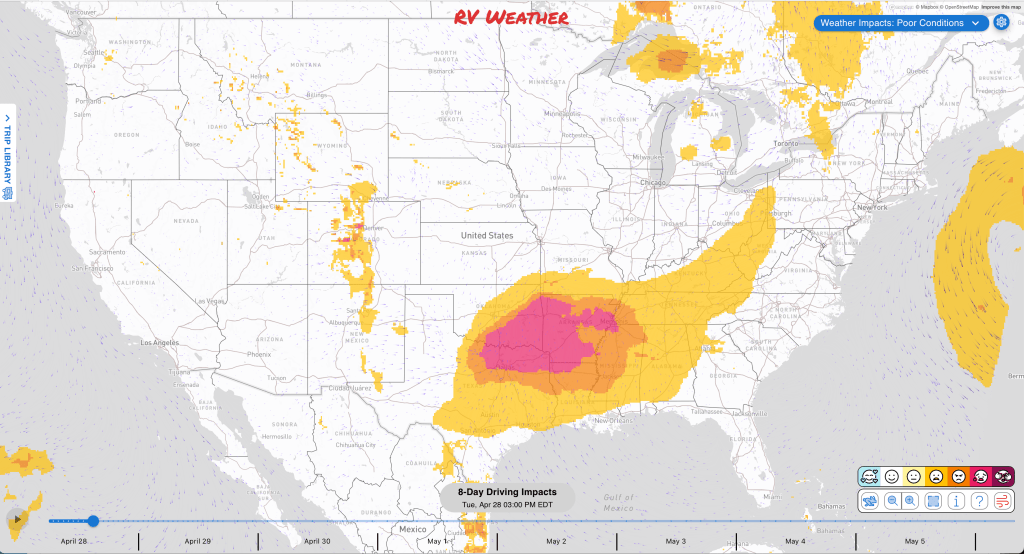
- Multiple rounds of strong to severe thunderstorms are likely this afternoon and evening across parts Texas into the lower Mississippi and Tennessee Valleys.
- Strong crosswinds through this afternoon across western New York and northwestern Pennsylvania.
- Snow this morning on the higher elevations of I-80 in southeast Wyoming.
What this means for your trip
- If you’re traveling across Texas, Oklahoma, Arkansas, Louisiana, Mississippi, Alabama, or Tennessee today, expect rapid changes from severe storms or heavy rain, especially this afternoon and evening.
- If you’re crossing southeast Wyoming early today, delaying until late morning should avoid slick travel on I-80.
- Trips across western and central New York or northwestern Pennsylvania should account for difficult crosswinds this morning. Winds ease up this afternoon.
- Routes through New Mexico, west Texas including the Texas Panhandle will be more difficult during the afternoon. Expect a crosswind on I-25 and I-27; and a head/tailwind on I-40.
Your route’s weather may vary from the general forecast — check your exact trip
48-hour access • No credit card required
Risk free – 30-day money-back guarantee
Want a deeper look at conditions?
Below are the significant weather alerts and travel impacts across the country:
Weather Impacts Pacific:
— No significant weather impacts to RV travel today or Wednesday.
Weather Impacts Mountain:
— Eastern Idaho plains: Freeze Watch late tonight through Wednesday morning with sub-freezing temperatures of 25 to 32 degrees expected in the Shoshone/Lava Beds, Arco/Mud Lake Desert, Lower Snake River Plain, and Upper Snake River Plain.
— South Laramie Range, Wyoming: Winter Weather Advisory this morning with 2 to 6 inches of snow, including the Interstate 80 Summit between Cheyenne and Laramie; slick roads, bridges, and overpasses may slow travel. I-80, US-30, and US-287 impacted.
— South-central Colorado: Red Flag Warning midday through early evening with west winds 15 to 25 mph and gusts up to 35 mph. US-160 and US-285 impacted.
— Sacramento and Capitan Mountains of New Mexico: Red Flag Warning late this morning through late evening with west winds 20 to 30 mph and gusts up to 40 mph in the Sacramento Mountain region; fires could spread rapidly in dry fuels. US-70, US-82, US-285, and US-380 impacted.
— Southeast and eastern New Mexico into west Texas: Red Flag Warning late this morning through late evening with west winds 15 to 30 mph and gusts 35 to 40 mph, locally near 45 mph near Clines Corners; dry, windy conditions may allow fires to spread rapidly. I-10, I-20, I-25, and I-40 impacted; US-54, US-56, US-60, US-62, US-67, US-70, US-82, US-84, US-87, US-90, US-180, US-285, US-380, and US-385 also affected.
Weather Impacts Central:
— Northeastern Minnesota: Flood Advisory through early evening from rain and snowmelt, with minor flooding in low-lying and poor-drainage areas and elevated river or stream flows. MN-61 potentially impacted.
— Texas Panhandle and northwest Texas: Red Flag Warning midday through late evening with west winds 10 to 25 mph and gusts 30 to 35 mph, very low humidity, and dry fuels; fires that develop may spread rapidly. I-27 and I-40 impacted; US-54, US-60, US-62, US-70, US-82, US-84, US-87, US-287, US-380, and US-385 also affected.
— Northwest and north-central Texas into southern Oklahoma: SEVERE THUNDERSTORM WATCH through midday with severe storms capable of damaging wind, hail, and torrential rain. I-35, I-44, US-62, US-69, US-70, US-75, US-77, US-82, US-83, US-183, US-277, US-281, US-287, and US-380 potentially impacted..
— South-central Illinois: FLASH FLOOD WARNING this morning after 3 to 6 inches of rain fell overnight, with flooding of roads and low-lying areas possible. I-57 and I-70 and surrounding highways potentially impacted.
— Most of central and eastern Texas, central and eastern Oklahoma, much of Arkansas, Mississippi, Alabama, Tennessee, Kentucky, central and southern Missouri, central and northern Louisiana, southern Illinois and Indiana, central and western Georgia: Severe thunderstorms this afternoon and evening with multiple rounds of strong to severe storms likely, including very large hail, swaths of damaging wind, and a few tornadoes. The greatest risk of severe weather will be across much of Arkansas, much of Mississippi, northeast Texas, northern Louisiana, and eastern Oklahoma. I-10, I-20, I-22, I-24, I-26, I-40, I-55, I-59, I-64, I-65, I-69, I-71, I-74, I-75, I-81, and I-85 potentially impacted.
— Southeastern Oklahoma, northeastern Texas, Arkansas, northern Louisiana, northern and central Mississippi and Alabama, and western Tennessee: Flash-flood risk today into tonight with numerous organized thunderstorms and high rain rates potentially above 2 inches per hour; 2 to 4 inches of rain is possible in places. I-20, I-22, I-24, I-30, I-35, I-40, I-45, I-49, I-55, I-57, I-59, I-65, I-69, I-75, and I-85 potentially impacted.
— Central, southern and eastern Texas, much of Louisiana, central and southern Mississippi and Alabama, western Florida Panhandle: Widely scattered strong to severe storms possible Wednesday afternoon through evening from south of the Texas Big Bend through the north-central Gulf Coast vicinity. I-10, I-12, I-20, I-22, I-35, I-37, I-45, I-49, I-55, I-59, I-65, and I-85 potentially impacted.
— Central and southwest Texas: Flash-flood risk Thursday into early Friday as increasing south to southeast inflow and low-level convergence support more numerous thunderstorms. I-10, I-14, I-20, I-30, I-35, I-37, and I-45 impacted.
Weather Impacts Eastern:
— Parts of south and southwest Indiana: FLOOD WARNINGS and Flood Advisories through late this evening after heavy rain last night; low-water crossings and river-adjacent roads may become difficult. Highways near I-64, I-65 I-69 may be impacted.
— Northwest PA, and western and central New York: Wind Advisories through afternoon with south to southeast winds 10 to 35 mph and gusts 45 to 55 mph, strongest near hilltops, northwest-facing slopes, and the Chautauqua Ridge; difficult crosswinds are possible for high-profile vehicles. I-79, I-86, I-90, I-99, US-6, US-20 and US-219 impacted.
— Vermont and eastern New York: Elevated fire-spread conditions through early evening with south to southeast winds gusting 20 to 30 mph. I-87, I-88, I-89, I-90, I-91, and I-93 impacted; US-2, US-4, US-5, US-7, and US-20 also affected.
— North Carolina and adjacent South Carolina, Virginia, West Virginia, Maryland, Delaware, DC, southern Pennsylvania, southeast Ohio, eastern Kentucky, and northeast Tennessee: Thunderstorms Wednesday afternoon into evening, Widely scattered strong storms pose at least some severe-weather risk from the Allegheny Plateau into the Mid-Atlantic. I-26, I-40, I-64, I-66, I-68, I-70, I-73, I-74, I-75, I-76, I-77, I-78, I-79, I-80, I-81, I-83, I-85, I-87, I-95, I-97, and I-99 potentially impacted.
Looking for real-time road conditions? Here’s a link, courtesy of the Federal Highway Administration, to all the individual State 511 websites.
Your route’s weather may vary from the general forecast — check your exact trip
48-hour access • No credit card required
Risk free – 30-day money-back guarantee
Selected travel-relevant Weather Graphics


Graphics for Today


Current Severe Thunderstorm and Tornado Watches from the National Weather Service Storm Prediction Center


Hail Size Forecast for today and tomorrow

Wildfire Smoke Forecast for today and tomorrow

Graphics for Tomorrow


National Weather Map for the Day after Tomorrow

Three-day Summaries


Day 3 – Day 7 U.S. Significant Weather Outlook

Access to real-time road information:
Phone numbers and websites for road conditions in all 50 states. Courtesy of the Cheyenne WY Weather Forecast Office
Some useful links:
Thank you for using RVWeather.