


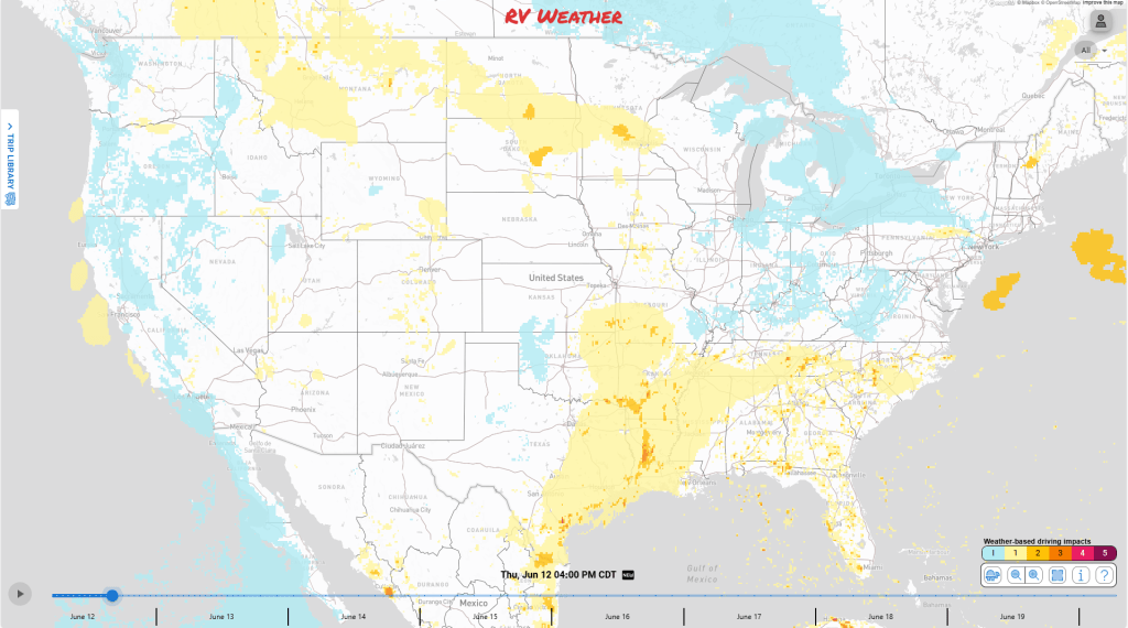
- Texas, Louisiana, and Arkansas remains very soggy with thunderstorms bringing severe winds, and hail, along with very heavy rainfall totals exceeding half-a-foot possible over today and tomorrow on top of already flooded areas.
- Severe thunderstorms and heavy rainfall are expected for the Northern Plains and Upper Mississippi River Valley today.
- Severe thunderstorms are expected for the High Plains today and tomorrow. Expect strong winds, large hail, and a tornado or two around.
From the RV Weather Field Office in Cochrane, WI:
These are the most significant weather impacts to RV travel over the next two to three days. I do not list every area of rain, showers, or breezy winds. It would be exhausting (for both of us!).
Looking for real-time road conditions? Here’s a link, courtesy of the Federal Highway Administration, to all the individual State 511 websites.
Looking for wildfire smoke or hail forecasts? Click here, then scroll down to “High Resolution, Hourly Animations”.
RV Weather’s Weather Hub has a complete collection of always updating weather graphics and forecasts.
Weather Impacts Pacific Time Zone:
— Central WA Cascades: Fog this morning will make for low visibilities. I-90 and Snoqualmie Pass impacted.
— Extreme southwest CA: Fog this morning will make for low visibilities of under 1/4 mile in the San Diego area mountains. I-8, I-15, CA-78, CA-79 impacted.
— Southern Sierra Mountains and Western Mojave Desert of CA: Wind gusts today of up to 40 mph are possible this afternoon and evening. I-15, US-395, CA-14, CA-58 impacted.
— Cascade Range of WA: Fog may form tomorrow morning. Visibilities under 1/4 mile are possible. I-90, US-2, US-12, Snoqualmie Pass, Stevens Pass impacted.
— Parts of Southwest OR: Fog may form tomorrow morning in and around the Klamath Mountains and Grants Pass. I-5, US-199 impacted.
— Extreme southwest CA: Fog can be around again tomorrow morning for the San Diego area mountains. I-8, I-15, CA-78, CA-79 impacted.
— Western NV, far northeastern CA: A combination of dry, warm air and wind gusts up to 35 – 40 mph makes for wildfire conditions. A Red Flag (Fire Weather) Watch is in effect tomorrow afternoon. I-80, US-50, US-95, US-395 impacted.
Weather Impacts Mountain Time Zone:
– Much of MT: Scattered thunderstorms are possible this afternoon. Localized heavy downpours are possible. I-15, I-90, US-12, US-87, US-89, US-93, US-191, US-212 impacted.
— Southeastern MT; western SD; eastern WY; western NE; eastern CO; eastern NM; far western TX: A few severe thunderstorms are possible this afternoon and overnight. Primarily a strong winds and large hail threat. I-25, I-40, I-70, I-76, I-80, I-90, US-50, US-385 impacted.
— Central and southern MT; northern and eastern WY; western SD; western NE; eastern CO: A few severe thunderstorms are expected tomorrow afternoon and night. Primary risks include strong winds and large hail. I-15, I-25, I-70, I-76, I-80, I-90, I-94, US-14, US-50, US-85, US-89, US-385 impacted
Weather Impacts Central Time Zone:
– Southern Plains into the Lower Mississippi River Valley. Some rivers remain flooded from excessive rainfall this past week. Do not drive across flooded roadways. More rainfall is expected later this week.
— Much of SD; northern and western NE; southern MN; northern IA: A few severe thunderstorms are possible this afternoon and overnight. Primary risks are strong winds and large hail. I-29, I-35, I-80, I-90, US-14, US-52, US-169, IA-60, MN-60 impacted.
— Southeast TX; northern and western LA; southeastern AR; western MS: A few severe thunderstorms are possible today. Primary risks include strong winds and a tornado or two. I-10, I-20, I-30, I-37, I-40, I-45, I-49, I-55, US-59, US-61, US-65, US-77, US-82, US-83, US-165, US-171 impacted.
— Portions of central and northeast TX; northwest LA; southwest AR: Flood watch is in effect through this evening. Thunderstorms across most of Texas, Louisiana, and Arkansas will bring prolonged heavy downpours. Widespread 2 – 5 inches of rainfall and localized areas could see up to 5 -7 inches. Do not drive through flooded roadways. I-10, I-20, I-30, I-35, I-45, I-49, US-59, US-75, US-79, US-171 impacted.
— Eastern SD; southeastern SD; southern and central MN; northern WI: Heavy rain from thunderstorms over today and tomorrow will bring an increased flood threat. Rainfall of 1 – 3 inches is expected with localized areas potentially seeing more. I-29, I-35, I-90, I-94, US-10, US-14, US-52, US-53, US-169, MN-60 impacted.
— Western SD; western NE; western KS; western OK; western TX: A few severe thunderstorms are expected tomorrow afternoon and night. Primary risks include strong winds and large hail. I-20, I-27, I-35, I-40, I-44, I-70, I-80, I-90, US-83 impacted.
— Eastern TX; LA; MS; AL; AR; eastern OK; MO; IL; KY; TN; MN; WI: Scattered thunderstorms tomorrow afternoon, locally heavy downpours possible.
Weather Impacts Eastern Time Zone:
— Eastern PA; northern NJ; New York City Area: A few severe thunderstorms are possible today. Primary risks include strong winds and large hail. I-78, I-80, I-81, I-87, I-95, I-287, I-380, I-476, Garden State Parkway impacted.
— Lower DelMaVa peninsula and southeastern VA: A Dense Fog Advisory is in effect this morning. Expect low visibilities under 1/4 mile at times. I-64, I-85, I-95, US-13, US-58 impacted.
– GA; FL; SC; NC: Scattered thunderstorms today will bring locally heavy downpours. Rain totals of a couple of inches are possible.
— White Mountains of NH and ME: Fog may develop today in higher elevations. Low visibilities under 1/4 mile are possible at times. I-93, US-2, US-302 impacted.
— IN; OH; western PA; KY; TN; GA; SC; NC; VA; WV; MD: Scattered thunderstorms tomorrow afternoon, locally heavy downpours possible.
Selected travel-relevant Weather Graphics


Graphics for Today

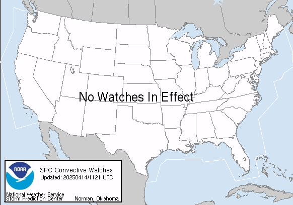
Current Severe Thunderstorm and Tornado Watches from the National Weather Service Storm Prediction Center


Wildfire Smoke Forecast for today and tomorrow

Graphics for Tomorrow


Three-day Summaries


Access to real-time road information:
Phone numbers and websites for road conditions in all 50 states. Courtesy of the Cheyenne WY Weather Forecast Office
Some useful links:
Thank you for using RVWeather.