


Planning to travel today or this week? Here’s what could impact your route – and what you should do.
- Severe storms and flash flooding risk building across Texas into the Gulf Coast through Saturday
- Heavy mountain snow and difficult pass travel across Colorado and northern New Mexico through Friday
- Strong crosswinds and blowing dust around Albuquerque on I-25 overnight into Friday morning
What this means for your trip
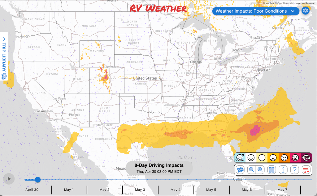
- Mountain routes in Colorado and northern New Mexico may require delaying departure or avoiding higher passes until snow and visibility improve. Conditions improve on I-70 on Friday. Avoid Raton Pass through Friday afternoon.
- High-profile RVs crossing the Albuquerque area on I-25 this evening into Friday morning should expect difficult crosswinds and possible blowing dust.
- Texas routes may need timing changes from tonight through Friday evening because storms and flash flooding. Heaviest rains will be along and south of I-20.
- Heavy but welcome rains on Saturday from New Orleans to Norfolk will slow your travel.
- Shoreline travel near the Baltimore, Annapolis, Alexandria, and Arlington areas may be disrupted by tidal flooding during this morning’s high-tide window.
Your route’s weather may vary from the general forecast — check your exact trip
48-hour access • No credit card required
Risk free – 30-day money-back guarantee
Want a deeper look at conditions?
Below are the significant weather alerts and travel impacts across the country:
Weather Impacts Pacific:
— No significant weather impacts to RV travel today or Friday.
Weather Impacts Mountain:
— I-80 between Laramie and Rawlins: Snow showers through this morning are reducing visibility to as low as one quarter mile between mile markers 250 and 290, with slushy, icy, or slick spots causing slower travel. I-80 impacted.
— Colorado Front Range, Mosquito Range, Summit County mountains, Indian Peaks, South Park, eastern Lake and Chaffee counties, and northwestern Fremont County: Winter Weather Advisory beginning this morning through Friday midday, with 5 to 13 inches of snow in the northern areas and 5 to 10 inches above 8500 to 9000 feet farther south; slushy and snow-covered roads may slow RV travel, especially over higher terrain and mountain passes. I-70, US-24, US-34, US-40, US-285 impacted.
— Colorado Teller County and the Rampart Range including Pikes Peak: Winter Storm Warning through Friday midday, with 8 to 16 inches of snow, highest on higher east-facing slopes; precipitation increases again late this morning into this evening, producing wet, slushy, and snowpacked roads. US-24 impacted.
— Colorado Sangre de Cristo Mountains and Wet Mountains: Winter Storm Warning beginning this morning through Saturday morning, with 8 to 16 inches of snow and difficult travel over mountain passes, including wet, slushy, and snowpacked roads. US-160, US-285 impacted.
— Northern New Mexico mountains including the Sangre de Cristo Mountains, Johnson and Bartlett Mesas, and Raton Pass: Winter Storm Warning beginning this afternoon through Saturday morning, with 2 to 8 inches of snow between 7500 and 9500 feet and 8 to 14 inches above 9500 feet; snow levels start near 9000 to 10000 feet, then drop to around 7500 feet Friday morning, with the heaviest snow late tonight through Friday morning. Travel may be very difficult over mountain passes, and tire chains may be necessary. I-25, US-64, US-87 impacted.
— Middle Rio Grande Valley including Albuquerque and Tijeras Pass: Wind Advisory beginning late evening through Friday morning, with east winds 25 to 35 mph and gusts up to 50 mph; strong crosswinds and areas of blowing dust may make travel difficult for high-profile RVs and trailers. I-25, I-40, US-550 impacted.
Weather Impacts Central:
— Northern Illinois into northwest Indiana: Patchy dense fog through this morning, especially along and east of I-57, may reduce visibility below one half mile in open areas, farm fields, river valleys, and ditches before improving later this morning. I-55, I-57, I-65, I-80, I-90, I-94 impacted.
— Central and southwest Texas: Severe thunderstorms are possible this evening into tonight, with isolated large hail possible as scattered thunderstorms develop in southwest Texas and increase overnight into south-central Texas. I-10, I-14, I-35, I-37, I-69E, US-59, US-67, US-77, US-79, US-83, US-84, US-87, US-90, US-190, US-277, US-281, US-285, US-290, US-385 potentially impacted.
— Central and southwest Texas: Flash flooding is possible today into early Friday as heavy rainfall develops, with rainfall rates approaching 2 to 3 inches per hour; high water and rapidly changing road conditions may affect low-lying and urban routes. I-10, I-14, I-35, I-37, US-59, US-67, US-77, US-79, US-83, US-84, US-87, US-90, US-190, US-277, US-281, US-285, US-290, US-385 potentially impacted.
— Parts of central and southern Texas: Isolated severe thunderstorms are possible Friday afternoon through Friday night, especially near middle Texas coastal areas, with locally difficult travel from storms and heavy downpours. I-10, I-35, I-37, I-45, I-69, I-69E, US-77 potentially impacted.
— Central and southeast Texas, much of Louisiana, and southern Mississippi: Flash flooding is possible Friday into Saturday morning as a slow-moving front and very high moisture support widespread heavy rainfall. I-10, I-12, I-14, I-20, I-35, I-37, I-45, I-49, I-55, I-59, I-69, I-69E potentially impacted.
— Much of Florida Panhandle, southeast Louisiana, coastal Alabama, and coastal Mississippi: Isolated severe thunderstorm development is possible Friday afternoon through Friday night, creating locally difficult travel from strong storms. I-10, I-12, I-55, I-59, I-65, US-19, US-27, US-29, US-43, US-49, US-61, US-84, US-90, US-98, US-167, US-190, US-231, US-431 potentially impacted.
Weather Impacts Eastern:
— Alexandria, Arlington, Annapolis, southern Baltimore County, and Baltimore shorelines: Coastal Flood Advisory through late morning, with up to one foot of inundation in Alexandria, Arlington, and Anne Arundel County and up to one half foot around southern Baltimore County and Baltimore; tidal flooding may put water near curbs, parking lots, promenades, and low-lying shoreline roads.
— Parts of western Florida Peninsula and adjacent southwest Georgia: Isolated severe thunderstorm development is possible Friday afternoon through Friday night, creating locally difficult travel from strong storms and heavy downpours. I-10, US-19, US-27, US-84, US-98, US-231, US-431 potentially impacted.
— Northern Florida Peninsula, eastern Florida Panhandle, and southern Georgia: Strong storms may occur Saturday, with some activity potentially becoming severe and causing quickly changing driving conditions. I-10, I-75, I-95, US-1, US-17, US-19, US-23, US-25, US-27, US-41, US-84, US-98, US-231, US-301 potentially impacted.
Looking for real-time road conditions? Here’s a link, courtesy of the Federal Highway Administration, to all the individual State 511 websites.
Your route’s weather may vary from the general forecast — check your exact trip
48-hour access • No credit card required
Risk free – 30-day money-back guarantee
Selected travel-relevant Weather Graphics


Graphics for Today


Current Severe Thunderstorm and Tornado Watches from the National Weather Service Storm Prediction Center


Hail Size Forecast for today and tomorrow

Wildfire Smoke Forecast for today and tomorrow

Graphics for Tomorrow


National Weather Map for the Day after Tomorrow

Three-day Summaries


Day 3 – Day 7 U.S. Significant Weather Outlook

Access to real-time road information:
Phone numbers and websites for road conditions in all 50 states. Courtesy of the Cheyenne WY Weather Forecast Office
Some useful links:
Thank you for using RVWeather.