


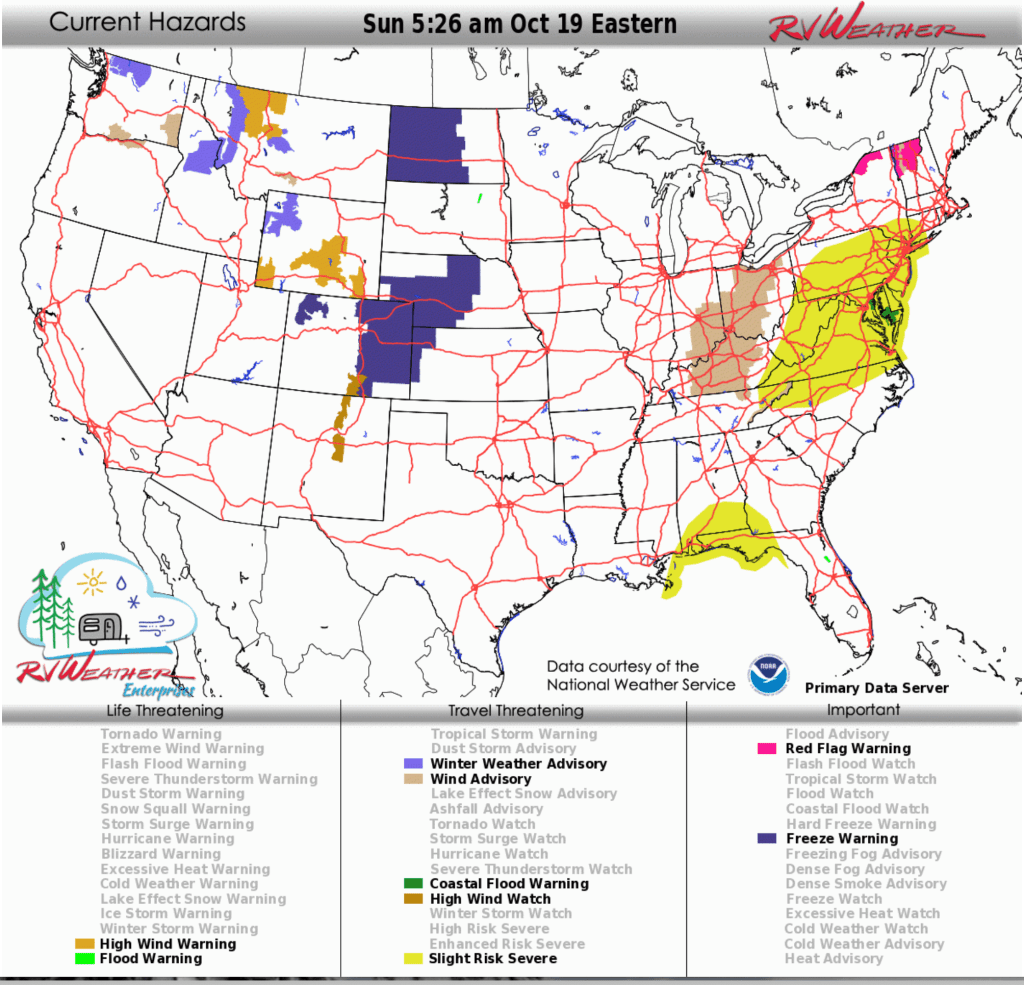
- Rain, thunderstorms, and strong winds today through tonight: From Michigan and Indiana east to New England, rain and storms move west to east with gusts 30–40 mph; isolated severe storms and a brief tornado possible late tonight along the I-95 corridor from Hartford to Baltimore.
- High Wind Warnings through this evening: Gusts 60–75 mph across north-central and northwest Montana, including Great Falls, Glacier National Park, and the Rocky Mountain Front.
- Winter Weather Advisories this evening through Monday morning: 2–5 inches of snow, up to 6 inches on higher passes, for western Montana, central Idaho and northwest Wyoming at higher elevations.
From the RV Weather Field Office in State College PA:
These are the most significant weather impacts to RV travel over the next two to three days. I do not list every area of rain, showers, or breezy winds. It would be exhausting.
Looking for real-time road conditions? Here’s a link, courtesy of the Federal Highway Administration, to all the individual State 511 websites.
Looking for wildfire smoke or hail forecasts? Click here, then scroll down to “High Resolution, Hourly Animations”. Or scroll down to the graphics below.
RV Weather’s free Weather Hub has a complete collection of always updating weather graphics and forecasts.
Weather Impacts Pacific Time Zone:
— Northwest and north-central WA above 4500 feet: Winter Weather Advisories continue through early tnight. 4-8 inches of snow expected. Washington Pass (WA-20) may see over a foot of snow. WA-20 impacted.
— South-central and southeast WA; north-central OR: Wind Advisories through early tonight. Wind gusts 50-55 mph. I-82 (south of Kennewick), I-84, US-12, US-97, US-195 impacted.
— Southern, east-central and southeast WA; much of OR east of the Cascades; northern NV, northeast CA: Strong winds today and tonight. Wind gusts 30-45 mph. Stronger winds in the above-mentioned Advisories. I-80, I-82, I-84, I-90, US-2, US-12, US-20, US-26, US-93, US-95, US-97, US-395 impacted.
— Much of WA; northern OR; northern ID: Rain, some heavy, spreads across this region today and this evening. Heaviest rain this morning. An additional 1-2 inches of rainfall on western-facing Cascade mountains. I-5, I-84, I-90, US-2, US-12, US-26, US-30, US-101 impacted.
Weather Impacts Mountain Time Zone:
— Northwest MT Rocky Mountain Front; north-central MT including Great Falls and Glacier National Park: High Wind Warnings through this evening. Wind gusts 60-75 mph. Strongest winds along the Rocky Mountain Front. I-15, US-2, US-89 impacted.
— Western MT; central ID above 5000 feet: Winter Weather Advisories this evening through Monday morning. 2-5 inches of snow expected. Up to 6 inches on the higher passes. Wind gusts 35-40 mph. US-2, US-12, US-89, US-93 impacted.
— South-central MT I-90 corridor east of Bozeman: Wind Advisory Beartooth Foothills and Livingston Area continues through this afternoon. Wind gusts to 60 mph. Strongest winds expected this morning. I-90, US-89 impacted.
— Much of central MT; southeast and southwest ID; most of WY; northwest, northwest and central CO: Strong winds today. Wind gusts mostly to 45 mph, except higher as described above by the High Wind Warnings and Advisories. I-15, I-25, I-70, I-80, I-90, US-2, US-12, US-14, US-16, US-20, US-24, US-26, US-30, US-34, US-40, US-87, US-89, US-191, US-287 impacted.
— Much of MT east of the Rockies; much of WY; central and eastern CO: Strong winds Monday and Monday evening. Wind gusts 30-50 mph. I-15, I-25, I-70, I-76, I-80, I-90, I-94 impacted.
— Much of southern and central WY: High Wind Warnings today, tonight and Monday morning. Wind gusts 55-65 mph. Winds strongest and longest-lasting across southeast WY. I-25, I-80, US-20, US-26, US-30, US-89, US-287
— Northwest and west-central WY, mainly above 8000 feet: Winter Weather Advisories midday today through midday Monday. 6-10 inches of snow expected. Wind gusts to 60 mph. US-14, US-16, US-20, US-26, US-89, US-212, WY-22 impacted.
— South-central CO (Raton Pass); north-central NM west of I-25; central NM east of Albuquerque: High Wind Watches late tonight through Monday afternoon. Wind gusts to 60 mph. I-25, I-40, US-54, US-60, US-64, US-285 impacted.
Weather Impacts Central Time Zone:
— Most of ND; SD; most of NE; central and western KS: Strong winds Monday and Monday night. Wind gusts 30-50 mph, except wind gusts 60-65 mph across western SD. Strongest winds in the northern and western parts of this region. I-26, I-70, I-80, I-90, I-94 highly impacted.
— Southeast IA and west-central IL; northern and western MO; southeast KS; eastern and central OK; north-central and central TX: Strong winds Monday from Chicago to Abilene TX. Wind gusts 30-35 mph. I-20, I-30, I-40, I-44, 49, I-55, I-64, I-70, I-72, I-74, I-80, I-88 impacted.
— Southeast WI; most of IL: Strong winds today. Wind gusts to 40 mph. I-39, I-41, I-43, I-55, I-57, I-64, I-70, I-72, I-74, I-80, I-88, I-90, I-94 impacted.
— South-central TX including San Antonio and Austin: Strong winds this morning and early afternoon. Wind gusts to 35 mph. I-10, I-35 impacted.
— Southern AL; FL Panhandle: Isolated severe thunderstorms are possible this morning. Wind gusts and a tornado or two are possible. I-10, I-65 potentially impacted.
Weather Impacts Eastern Time Zone:
— MI Lower Peninsula; IN; OH; central and eastern KY; PA; NY; NJ; New England: Rain, rain showers and thunderstorms, move across this region from west to east. Rain reaches western NY, central PA and western VA by this evening, and eastern New England by early Monday morning. Rainfall ends by late Monday night across ME. Rainfall amounts of 1/2 to 1.5 inches will be common. I-64, I-65, I-69, I-70, I-71, I-74, I-75, I-76, I-77, I-78, I-80, I-81, I-83, I-84, I-86, I-87, I-88, I-89, I-90, I-91, I-93, I-94, I-95, I-96, IN Toll Road, OH, PA, NJ, MA Turnpikes, Garden State Parkway, NY Thruway impacted.
— Much of central and southwest OH; southeast IN; central KY; north-central TN: Wind Advisories through midday today. Wind gusts 30-40 mph will be common, with isolated gusts to 50 mph. I-64, I-65, I-69, I-70, I-71, I-74, I-75, I-76, I-80, I-90, OH Turnpike impacted.
— MI Lower Peninsula; much of IN; OH; western NY; PA west of I-81; central and northern WV; central and western MD; northern and northwest VA: Strong winds develop this morning and spread west to east by this afternoon.afternoon. Wind gusts 30-35 mph, except stronger where noted in the Advisories above. I-64, I-65, I-66, I-68, I-69, I-70, I-71, I-75, I-76, I-77, I-78, I-79, I-80, I-81, I-83, I-86, I-90, I-94, I-96, NY Thruway, PA and OH Turnpikes, IN Toll Road impacted.
— Most of PA, MD, WV, VA; northeast TN; northern and western NC; southern NY; NJ; DELMARVA Peninsula; CT: Isolated severe thunderstorms with a threat mainly for damaging winds are possible later today through late tonight. A brief tornado is possible late tonight along the I-95 corridor from Hartford to Baltimore, as well as NJ and the DELMARVA Peninsula. I-26, I-40, I-64, I-66, I-68, I-70, I-71, I-75, I-76, I-77, I-78, I-79, I-80, I-81, I-84, I-85, I-87, I-90, I-91, I-95, I-99, OH, NJ, PA Turnpikes, Garden State Parkway, NY Thruway potentially impacted.
— Central PA; western MD; eastern WV: Strong winds tonight through midday Monday. Wind gusts to 40 mph. I-64, I-68, I-70, I-76, I-80, I-99, US-22, US-30, US-219 impacted.
— Northern NY; northern and central VT: Red Flag (fire danger) Warnings through this evening in the St. Lawrence and Champlain Valleys and Northeast Kingdom. Wind gusts 35-40 mph. I-81, I-89, I-91, I-93, US-11 impacted.
— Portions of northeast VT western slopes of the northern Green Mountains: Wind Advisories tonight and Monday morning. Wind gusts to 50 mph. I-89 impacted.
— Eastern TN, along the NC Border: Wind Advisory continues through this afternoon. Wind gusts 45-55 mph. I-26, I-40 impacted.
— Much of the coastal Chesapeake and western Delaware Bays: Coastal Flood Warnings and Advisories today and tonight. Up to 1-2 feet of inundation expected. Flooding will extend inland from the waterfront along tidal rivers and bays resulting in some road closures.
Selected travel-relevant Weather Graphics


Graphics for Today


Current Severe Thunderstorm and Tornado Watches from the National Weather Service Storm Prediction Center


Hail Size Forecast for today and tomorrow

Wildfire Smoke Forecast for today and tomorrow

Graphics for Tomorrow


National Weather Map for the Day after Tomorrow

Three-day Summaries


Day 3 – Day 7 U.S. Significant Weather Outlook

Access to real-time road information:
Phone numbers and websites for road conditions in all 50 states. Courtesy of the Cheyenne WY Weather Forecast Office
Some useful links:
Thank you for using RVWeather.