


Planning to travel today or this week? Here’s what could impact your route – and what you should do.
- Strong desert crosswinds in southern California
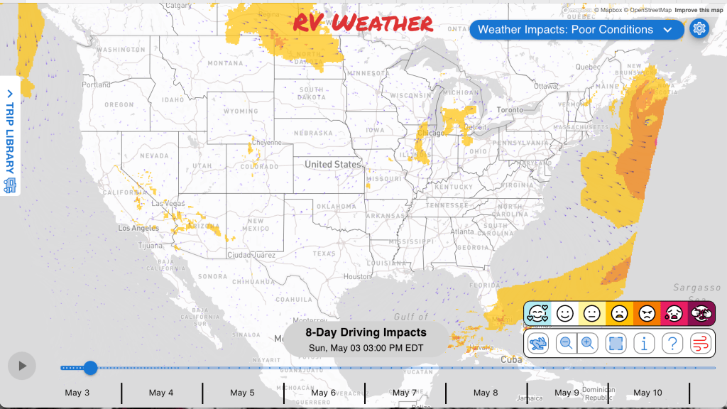
- Winter storm risk over southeast Wyoming high terrain Monday evening through Wednesday.
- Severe storm chances build across the central U.S; Tuesday and Wednesday likely will see the strongest storms.
What this means for your trip
- Delay or adjust desert travel in southern California where strong crosswinds could make high-profile RV handling difficult.
- Consider avoiding travel over the I-80 high terrain in southeast Wyoming Monday night into Wednesday.
- Watch departure timing across the central U.S. as thunderstorm risks increase from Sunday through Tuesday. Most of the severe storms will be in the late afternoon, evening or nighttime hours.
- Morning fog in parts of the Southeast this morning may require slower or later starts and extra following distance.
Your route’s weather may vary from the general forecast — check your exact trip
48-hour access • No credit card required
Risk free – 30-day money-back guarantee
Want a deeper look at conditions?
Below are the significant weather alerts and travel impacts across the country. Check out the extended forecast through May 10th at the end.
Weather Impacts Pacific:
— Greater Portland and Vancouver metro into the Lower Columbia, Cowlitz River, and Tualatin Valleys: Heat Advisory beginning this morning through late tonight, with temperatures up to 90 to 91 degrees, significant overnight cooling, and near-record warmth for this time of year.
— Death Valley, Owens Valley, Lake Mohave, Esmeralda and central Nye County: Wind Advisory beginning late this morning through late evening, with south winds 20 to 30 mph and gusts up to 45 mph creating difficult travel in open desert terrain. US-6, US-93, US-95, US-395, CA-168 impacted.
— Western Mojave Desert, Indian Wells Valley, Mojave Desert, Mojave Desert Slopes, and Tehachapi Pass on CA-58: Wind Advisory beginning late this morning through Tuesday morning, with southwest winds 15 to 35 mph and gusts up to 45 to 55 mph creating hazardous crosswinds, especially through desert gaps and pass routes. I-15, I-40, US-395, CA-14, CA-58 impacted.
— Western Imperial County and the Imperial Valley: Wind Advisory beginning early evening through Monday morning, with west to southwest winds 20 to 40 mph and gusts up to 45 to 60 mph creating hazardous crosswinds for high-profile vehicles and difficult driving for larger RVs. I-8, CA-78, CA-86 impacted.
Weather Impacts Mountain:
— Northeast Montana: Red Flag Warning beginning late this morning through late evening, with west to northwest winds 15 to 25 mph gusting up to 40 mph and humidity as low as 10 to 15 percent; any fire that develops may spread rapidly. I-94, US-2 impacted.
— Southeast Wyoming: Red Flag Warning beginning late this morning through late evening, with northwest winds 10 to 20 mph gusting 25 to 30 mph, humidity between 12 and 15 percent, and isolated virga showers that may produce erratic winds with little rainfall. I-25, I-80, US-30, US-85 impacted.
— South Laramie Range, North Snowy Range Foothills, Arlington, Elk Mountain, and the I-80 Summit between Cheyenne and Laramie: Winter Storm Watch beginning Monday evening through Wednesday, with 4 to 10 inches of snow possible and gusts as high as 45 mph; falling and blowing snow may reduce visibility and lead to slushy or icy road conditions over higher terrain. I-25, I-80, US-30, US-85, US-287 potentially impacted.
Weather Impacts Central:
— North Dakota: Red Flag Warning beginning late this morning through late evening, with west winds 20 to 30 mph and gusts up to 45 mph, humidity as low as 15 to 25 percent, and rapidly spreading fires possible. I-29, I-94, US-2, US-52, US-83, US-85, US-281 impacted.
— Southern Illinois, southwest Indiana, western Kentucky, and southeast Missouri: Patchy dense fog through morning, especially where rain fell Saturday, with reduced visibility improving an hour or two after sunrise. I-24, I-55, I-57, I-64, I-69, US-60, US-68 impacted.
— Much of Missouri and central and southern Illinois: A few strong thunderstorms are possible today into this evening as isolated storms develop along a weak front; locally stronger storms could create sudden slowdowns and difficult driving for RVs. I-29, I-35, I-44, I-49, I-55, I-57, I-64, I-70, I-72 potentially impacted.
— Much of Missouri, much of Illinois, southern, central and eastern Iowa, eastern Kansas, and southern Wisconsin: Strong to severe thunderstorms are possible late Monday afternoon into Monday night as a cold front and dryline organize storms across the Midwest. I-29, I-35, I-39, I-41, I-43, I-44, I-49, I-55, I-57, I-64, I-70, I-72, I-74, I-80, I-88, I-90, I-94 potentially impacted.
— Central and northeastern Texas, much of Arkansas, south-central and eastern Oklahoma, and southern Missouri: Isolated to scattered strong to severe storms are possible Tuesday afternoon and evening from eastern Oklahoma and northeast Texas into the Mid-South. The greatest risk of severe weather will be across much of Arkansas, eastern Oklahoma, parts of central and northern Texas, and parts of southern Missouri. I-14, I-20, I-22, I-24, I-30, I-35, I-40, I-44, I-45, I-49, I-55, I-57, I-69 potentially impacted.
Weather Impacts Eastern:
— Much of Indiana, northwest Ohio, and southern Michigan Lower Peninsula: Strong to severe thunderstorms are possible late Monday afternoon into Monday night as storms develop along a southeast-moving cold front; RV travel may become more difficult where storms produce sudden wind, rain, and visibility reductions. I-57, I-65, I-69, I-70, I-71, I-74, I-75, I-80, I-90, I-94, I-96 potentially impacted.
— Lower Hudson Valley, New York City, Long Island, Mid-Hudson Valley, eastern Catskills, Taconics, Greater Capital District, and Lake George-Saratoga regions: Elevated fire spread risk through late evening, with northwest wind gusts between 20 and 30 mph and relative humidity between 25 and 35 percent. I-84, I-86, I-87, I-88, I-90, I-95, US-20 impacted.
— Inland southeast Georgia, northeast and north-central Florida, the Suwannee Valley, and southern southeast South Carolina: Patchy to locally dense fog through late morning, with visibility occasionally below one half mile and locally below one quarter mile near marshes, swamps, ditches, rivers, creeks, and lakes. I-10, I-16, I-75, I-95, US-1, US-17, US-23, US-25, US-27, US-41, US-84, US-280, US-301 impacted.
Outlook through May 9th:
— Tuesday, May 5 through Friday, May 8: across parts of the northern Plains and Upper Midwest: Frost or freeze conditions possible.
— Tuesday, May 5: from the Lower Mississippi Valley into the Ohio Valley and lower Great Lakes: Heavy rain may create localized flooding or difficult travel conditions. Major highways potentially affected include I-30, I-40, I-55, I-64, I-65, I-70, I-71, I-74, I-75, I-76, I-79, I-80, I-90.
— Wednesday, May 6 through Thursday, May 7: from the central Rockies into the central Plains and Upper Midwest: Frost or freeze conditions possible.
— Wednesday, May 6 through Friday, May 8: southeastern Minnesota, northeastern Iowa, much of Wisconsin, and much of Michigan: Frost or freeze conditions possible.
— Wednesday, May 6: eastern Texas, southern Arkansas, Louisiana, Mississippi, and Alabama: Heavy rain may create localized flooding or difficult travel conditions. Major highways potentially affected include I-10, I-20, I-30, I-35, I-55, I-65.
— Wednesday, May 6: from eastern Texas and the Lower Mississippi Valley into the Tennessee Valley, central Appalachians, and parts of the Northeast: Severe thunderstorms may create difficult travel conditions. Major highways potentially affected include I-20, I-30, I-40, I-55, I-64, I-65, I-70, I-75, I-76, I-79, I-80, I-81, I-84.
— Thursday, May 7: eastern New York and New England: Heavy rain may create localized flooding or difficult travel conditions. Major highways potentially affected include I-80, I-84, I-87, I-90, I-91, I-95.
— Friday, May 8 through Saturday, May 9: from the central Appalachians into Pennsylvania, New York, and northern New England: Frost or freeze conditions are possible.
Extended Outlook May 10th through May 15th:
— Sunday, May 10 through Friday, May 15: southeastern California, southeastern Nevada, and much of Arizona: Hazardous heat may develop, which could create challenging travel conditions. Major highways potentially affected include I-8, I-10, I-15, I-40.
— Sunday, May 10 through Wednesday, May 13: southeastern California, much of Nevada, southwestern Utah, and northwestern Arizona: Strong winds may develop, which could create hazardous crosswinds for high-profile vehicles. Major highways potentially affected include I-15, I-40.
— Sunday, May 10 through Tuesday, May 12: from southeastern Oklahoma and Texas into the Lower Mississippi Valley and parts of the Southeast: Heavy rain may develop, which could create localized flooding or difficult travel conditions. Major highways potentially affected include I-10, I-20, I-30, I-35, I-55, I-65, I-85.
— Sunday, May 10: much of Florida: Hazardous heat may create challenging travel conditions, especially for long drives and exposed routes. Major highways potentially affected include I-4, I-75, I-95.
— Sunday, May 10: from the Great Lakes into the Ohio Valley, central Appalachians, Mid-Atlantic, and Northeast: Colder-than-normal temperatures may develop, which could create cold-weather travel concerns and issues for exposed plumbing or early-season travel. Major highways potentially affected include I-40, I-64, I-65, I-70, I-71, I-74, I-75, I-76, I-79, I-80, I-81, I-84, I-87, I-90, I-91, I-94, I-95.
— Sunday, May 10 through Tuesday, May 12: from Michigan and Ohio into the central Appalachians, Mid-Atlantic, and Northeast: Strong winds may develop, which could create hazardous crosswinds for high-profile vehicles. Major highways potentially affected include I-64, I-70, I-71, I-75, I-76, I-79, I-80, I-81, I-84, I-85, I-87, I-90, I-91, I-94, I-95.
— Wednesday, May 13 through Friday, May 15: from the Ohio Valley and central Appalachians into the Mid-Atlantic and Northeast: Heavy rain may develop, which could create localized flooding or difficult travel conditions. Major highways potentially affected include I-64, I-70, I-76, I-79, I-80, I-81, I-84, I-87, I-90, I-91, I-95.
Forecast Confidence for the Extended Outlook:
Confidence is generally good early in the period, with stronger agreement on the broad pattern. Confidence becomes more limited later as model spread increases, especially regarding timing, smaller-scale features, and western U.S. details.
Looking for real-time road conditions? Here’s a link, courtesy of the Federal Highway Administration, to all the individual State 511 websites.
Your route’s weather may vary from the general forecast — check your exact trip
48-hour access • No credit card required
Risk free – 30-day money-back guarantee
Selected travel-relevant Weather Graphics


Graphics for Today


Current Severe Thunderstorm and Tornado Watches from the National Weather Service Storm Prediction Center


Hail Size Forecast for today and tomorrow

Wildfire Smoke Forecast for today and tomorrow

Graphics for Tomorrow


National Weather Map for the Day after Tomorrow

Three-day Summaries


Day 3 – Day 7 U.S. Significant Weather Outlook

Access to real-time road information:
Phone numbers and websites for road conditions in all 50 states. Courtesy of the Cheyenne WY Weather Forecast Office
Some useful links:
Thank you for using RVWeather.