


Planning to travel today or this week? Here’s what could impact your route – and what you should do.
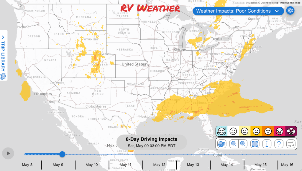
- Severe storms target the Plains, Gulf states, and Southeast. Strongest storms expected Sunday.
- Extreme heat builds in the Southwest, California deserts and Central Valley Sunday through Thuesday.
- Flash-flood risk continues today in Louisiana and southern Mississippi
What this means for your trip
- Severe storms today through Monday may require flexible stop planning across the Plains, Gulf states, Southeast, Great Lakes, and Mid-Atlantic. Greatest risk of intense storms will be across central and northeast Texas Sunday afternoon and evening. Your RV is not a tornado shelter.
- Heat-sensitive travelers in the Southwest and California should consider earlier starts, shorter driving days, or delaying exposed stops during the hottest afternoon periods.
- Areas of dense fog this morning across parts of the central U.S. may justify delaying departure until visibility improves.
- Flash-flood risk in Louisiana and southern Mississippi makes overnight parking choices more important. Do not cross flooded roads, especially after dark.
Your route’s weather may vary from the general forecast — check your exact trip
48-hour access • No credit card required
Risk free – 30-day money-back guarantee
Want a deeper look at conditions?
Below are the significant weather alerts and travel impacts across the country for the next 2-3 days.
Check out the extended forecast through May 18th at the end of the short-term forecast.
Weather Impacts Pacific:
— Southern California deserts: Extreme Heat Warning beginning Sunday morning through Monday evening, with dangerously hot afternoon temperatures of 101 to 112 degrees in the Imperial County deserts and 104 to 109 degrees in the Coachella Valley, San Diego County deserts, and San Gorgonio Pass near Banning; heat-related illness risk increases significantly, with the hottest conditions expected Monday.
— Central California: Heat Advisory beginning Monday morning through Tuesday evening, with temperatures up to 95 to 100 in parts of the Sacramento Valley and up to 102 in parts of central California, creating heat illness concerns, especially in hotter foothill and urban areas.
Weather Impacts Mountain:
— Central and southeastern Wyoming into parts of northeast Colorado: Severe thunderstorms are possible this afternoon and evening, with large hail, and locally damaging wind gusts. I-25, I-70, I-76, I-80, US-6, US-18, US-20, US-24, US-26, US-30, US-34, US-36, US-40, US-85, US-287, US-385 potentially impacted.
— Northwest Colorado: Red Flag Warning this afternoon through late evening, with northwest winds 15 to 25 mph gusting up to 35 mph and relative humidity of 11 to 16 percent; fires may catch and spread quickly. US-40 impacted.
— Phoenix metro area: Extreme Heat Warning beginning Sunday morning through Monday evening, with dangerously hot afternoon temperatures of 105 to 109 degrees and increasing heat-related illness concerns.
Weather Impacts Central:
— Northwest and north central North Dakota: Red Flag Warning beginning around midday through late evening, with northwest winds around 20 mph, gusts up to 30 mph, relative humidity as low as 15 percent, and any fires that ignite likely to spread rapidly. US-2, US-52, US-83, US-85 impacted.
— Southeast Kansas, Missouri, and central Illinois: Dense Fog Advisory through morning, with visibility one quarter mile or less in many areas and less than one mile in parts of Illinois, causing hazardous driving conditions and rapidly changing visibility. I-35, I-39, I-44, I-49, I-55, I-57, I-64, I-70, I-72, I-74 impacted.
— Much of Oklahoma, central and western Kansas, adjacent northern Texas, and southwest Nebraska: Severe thunderstorms are possible this afternoon and evening, with widely scattered storms capable of large to very large hail, locally damaging wind gusts, and perhaps a few tornadoes. The greatest risk of severe weather will be in central Oklahoma and parts of adjacent northern Texas. I-35, I-40, I-44, I-70, I-76, I-80 potentially impacted.
— East central and northeast Oklahoma: Dense Fog Advisory through morning, with visibility less than one quarter mile and rapidly changing visibility creating hazardous driving conditions. I-40, I-44, US-60, US-64, US-69, US-75, US-412 impacted.
— West-central Texas: Dense Fog Advisory through late morning, with visibility less than one quarter mile at times including the I-10 corridor from Ozona to Junction. I-10, US-83, US-87, US-190, US-277, US-290 impacted.
— Central and southern Texas, much of Louisiana, central and southern Mississippi, central and southern Alabama, and the Florida Panhandle: A few severe storms are possible this afternoon and evening, with occasional large hail and damaging wind occurrences possible. I-10, I-12, I-35, I-37, I-45, I-49, I-55, I-59, I-65, I-69, I-69E potentially impacted.
— Southwest Mississippi: FLASH FLOOD WARNING until 9:45 AM CDT, with 2 to 3 inches of rain already fallen and another 1 to 2 inches possible, causing flash flooding of small creeks and streams, urban areas, highways, streets, underpasses, and poor-drainage low spots. I-55, US-61, US-98 impacted.
— Parts of Louisiana and southern Mississippi: Flash flooding is possible today into tonight where recent flooding has left already saturated grounds. Any additional heavy rain is likely to pose renewed runoff problems. I-10, I-12, I-49, I-55, I-59, US-49, US-61, US-71, US-90, US-165, US-167, US-190 potentially impacted.
— Much of Texas, southern Oklahoma, Louisiana, Mississippi, and much of Arkansas: Severe thunderstorms are likely Sunday afternoon and evening, with large hail and damaging wind gusts; hail greater than 2 inches and severe wind gusts above 70 mph are possible in the stronger storms. The greatest risk of severe weather will be in parts of central and northern Texas, including the Dallas Ft Worth Metroplex. I-10, I-12, I-14, I-20, I-22, I-27, I-30, I-35, I-37, I-40, I-44, I-45, I-49, I-55, I-59, I-65, I-69, I-85 potentially impacted.
— Central and southern Alabama, central and southern Louisiana, much of Florida Panhandle, and parts of southern Mississippi: Isolated severe storms with locally damaging wind gusts are expected Monday midday into afternoon, with storms developing along and ahead of a cold front. I-10, I-12, I-49, I-55, I-59, I-65, I-85 potentially impacted.
Weather Impacts Eastern:
— Northern Michigan Lower Peninsula: Elevated fire danger through late evening, with dry surface conditions, low afternoon relative humidity, and sustained west to northwest winds of 10 to 18 mph with occasional gusts of 20 to 30 mph. I-75, US-23, US-31, US-131 impacted.
— Michigan Lower Peninsula: Freeze Warning Sunday morning, with sub-freezing temperatures as low as 28 degrees in northern Michigan Lower Peninsula and as low as 30 degrees in Clare, Osceola, and Lake Counties.
— Anne Arundel County shoreline in Maryland: Coastal Flood Advisory beginning late this morning through midday, with up to one half foot of inundation above ground level expected in low-lying areas due to tidal flooding, especially around the late-morning high tide.
— Central and southern Georgia and northern Florida: A few severe storms are possible this afternoon and evening, with occasional large hail and damaging wind occurrences possible. I-10, I-16, I-75, I-95, US-1, US-17, US-19, US-23, US-25, US-27, US-41, US-82, US-84, US-98, US-280, US-301, US-431 potentially impacted.
— Central and northern Ohio, southeast Michigan Lower Peninsula, parts of western New York and Pennsylvania: A few severe storms are possible this afternoon and evening, with occasional large hail and damaging wind occurrences possible across the Great Lakes region. I-69, I-71, I-75, I-76, I-77, I-79, I-80, I-86, I-90, I-94, I-96 potentially impacted.
— Much of New Jersey, parts of southeastern Pennsylvania, eastern Maryland, and much of Delaware: A few severe storms are possible this afternoon and evening, with occasional large hail and damaging wind occurrences possible near the mid-Atlantic. I-70, I-76, I-78, I-83, I-95, I-97 potentially impacted.
— Florida and central and southern Georgia: Severe thunderstorms are likely Sunday afternoon and evening, with large hail and damaging wind gusts possible as storms develop ahead of a southward-moving front. I-4, I-10, I-16, I-75, I-95, US-1, US-17, US-19, US-23, US-25, US-27, US-41, US-80, US-82, US-84, US-98, US-280, US-301, US-431, FL-A1A potentially impacted.
— Much of Georgia, central and northern Florida, much of South Carolina, and southeastern North Carolina: Isolated to scattered severe storms with locally damaging wind gusts are expected Monday midday into afternoon, with storms developing along and ahead of a cold front. I-4, I-10, I-16, I-20, I-26, I-40, I-74, I-75, I-77, I-85, I-95 potentially impacted.
Outlook through May 15th:
Sunday, May 11: portions of eastern Florida: Heat concerns may create challenging conditions. Major highways potentially affected include I-75, I-95.
Sunday, May 11: portions of southern Minnesota, Wisconsin, and northwestern Michigan: Frost or freeze concerns may create challenging conditions for early season RVers. Major highways potentially affected include I-94.
Sunday, May 11 through Monday, May 12: much of Michigan: Frost or freeze concerns may create challenging conditions for early season RVers. Major highways potentially affected include I-75.
Monday, May 12: portions of the Ohio Valley, central Pennsylvania and eastern West Virginia: Frost or freeze concerns may create challenging conditions for early season RVers. Major highways potentially affected include I-64, I-70, I-76, I-80, I-90.
Extended Outlook May 16th through May 22nd:
Friday, May 16 through Monday, May 19: portions of Washington, western Oregon, and northwestern California: Strong winds may develop, which could create hazardous crosswinds for high-profile vehicles. Major highways potentially affected include I-5, I-80, I-84.
Friday, May 16 through Sunday, May 18: from Idaho and Montana into Wyoming, the western Dakotas, and northwestern Nebraska: Strong winds may develop, which could create hazardous crosswinds for high-profile vehicles, especially over higher terrain including Homestake Pass and Bozeman Pass. Major highways potentially affected include I-15, I-25, I-80, I-90, I-94.
Sunday, May 17 through Wednesday, May 20: from Texas and Oklahoma into the Lower Mississippi Valley: Heavy rain may develop, which could create localized flooding and reduced visibility. Major highways potentially affected include I-10, I-20, I-29, I-30, I-35, I-40, I-70.
Forecast Confidence for the Extended Outlook:
Confidence is generally average through the earlier part of the outlook, with fairly good agreement on the broader weather pattern across the country. Confidence decreases later in the period as the pattern becomes more transitional, with greater uncertainty in how western U.S. systems evolve and how precipitation areas develop.
Looking for real-time road conditions? Here’s a link, courtesy of the Federal Highway Administration, to all the individual State 511 websites.
Your route’s weather may vary from the general forecast — check your exact trip
48-hour access • No credit card required
Risk free – 30-day money-back guarantee
Selected travel-relevant Weather Graphics


Graphics for Today


Current Severe Thunderstorm and Tornado Watches from the National Weather Service Storm Prediction Center


Hail Size Forecast for today and tomorrow

Wildfire Smoke Forecast for today and tomorrow

Graphics for Tomorrow


National Weather Map for the Day after Tomorrow

Three-day Summaries


Day 3 – Day 7 U.S. Significant Weather Outlook

Access to real-time road information:
Phone numbers and websites for road conditions in all 50 states. Courtesy of the Cheyenne WY Weather Forecast Office
Some useful links:
Thank you for using RVWeather.