


Planning to travel today or this week? Here’s what could impact your route – and what you should do.
- Strong storms and heavy rains today in Florida and the lower Southeast
- Gusty desert winds may affect RV travel across southeast California and adjacent Nevada starting Sunday.
- Much cooler than normal temperatures for the first half of May in the Eastern US; expect lingering frost and freeze conditions.
What this means for your trip
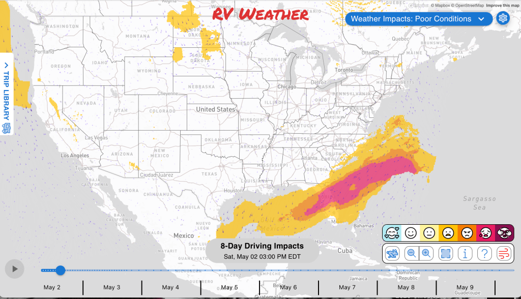
- Florida and the Southeast may see heavy rain showers and strong to severe thunderstorms for much of today. Sunday will be a much better travel day.
- Sunday wind in the Mojave and Tehachapi areas may favor delaying travel or avoiding exposed high-profile driving.
- Good travel conditions throughout the Mountain Time Zone this weekend.
- Be prepared for cold overnight temperatures in the central Appalachians Sunday morning. Cold nights will linger in the East for the next couple of weeks.
Your route’s weather may vary from the general forecast — check your exact trip
48-hour access • No credit card required
Risk free – 30-day money-back guarantee
Want a deeper look at conditions?
Below are the significant weather alerts and travel impacts across the country. Check out the extended forecast through May 10th at the end.
Weather Impacts Pacific:
— Greater Portland, Lower Columbia, Cowlitz River Valley, and Tualatin Valley areas of Oregon and Washington: Heat Advisory beginning Sunday morning through Sunday night, with temperatures up to 90 to 91 degrees and significant overnight cooling expected.
— Eastern California, southern Nevada, and the Lake Mohave area, including Death Valley National Park: Wind Advisory beginning Sunday morning through Sunday evening, with south winds 20 to 30 mph and gusts up to 45 mph creating difficult driving for high-profile RVs and trailers. US-6, US-93, US-95, US-395, CA-168 impacted.
— Western Mojave Desert and Tehachapi Pass on CA-58: Wind Advisory beginning Sunday afternoon through Monday night, with southwest winds 20 to 30 mph and gusts up to 45 mph creating hazardous crosswinds and difficult travel for high-profile vehicles. I-15, I-40, US-395, CA-58 impacted.
Weather Impacts Mountain:
— No significant impacts to RV travel today or Sunday.
Weather Impacts Central:
— Coastal South Texas: Wind Advisory through late morning, with north winds 15 to 25 mph and gusts up to 30 mph creating gusty travel for RVs and trailers. I-37, US-87 impacted.
— Much of Florida Panhandle: Strong to severe thunderstorms are possible today. The greatest risk of severe weather will be in the central and eastern Florida Panhandle. I-10, US-19, US-27, US-84, US-98, US-231 potentially impacted.
— Missouri and central and southern Illinois: A few strong thunderstorms are possible Sunday. I-29, I-35, I-44, I-49, I-55, I-57, I-64, I-70, I-72 potentially impacted.
— Central and northern Missouri, much of Illinois, parts of eastern Kansas, and parts of southern Iowa: Strong to severe thunderstorms are possible late Monday afternoon into Monday night as a cold front moves into the region. I-29, I-35, I-39, I-44, I-49, I-55, I-57, I-64, I-70, I-72, I-74, I-80, I-90, I-94 potentially impacted.
Weather Impacts Eastern:
— Much of Indiana, much of Ohio, and parts of southern Michigan Lower Peninsula: Strong to severe thunderstorms are possible late Monday afternoon into Monday night as a cold front moves into the region. I-65, I-69, I-70, I-71, I-74, I-75, I-76, I-80, I-90, I-94 potentially impacted.
— Parts of Pennsylvania, northeast Kentucky, southeast Ohio, southwest Virginia, West Virginia, western Maryland, and the central Appalachians: Freeze Watch late tonight through Sunday morning, with sub-freezing temperatures possible, including lows around 30 in Kentucky valleys, as low as 30 in parts of Pennsylvania, Maryland, Virginia, and West Virginia, and as low as 29 in parts of northern West Virginia.
— Kentucky and southern Ohio valley areas: Patchy dense fog through late morning, especially in valley areas, with rapid visibility changes before improvement later in the morning. I-70, US-23, US-50 impacted.
— Anne Arundel County shoreline in Maryland: Coastal Flood Advisory through morning, with up to one foot of inundation above ground level expected in low-lying areas around high tide.
— Central and northern Florida Peninsula and parts of southern Georgia: Strong to severe thunderstorms are possible today as a cold front focuses thunderstorm development, with a few stronger storms possible. The greatest risk of severe weather will be across central and northern Florida Peninsula and parts of southern Georgia. I-4, I-10, I-75, I-95, US-1, US-17, US-19, US-23, US-25, US-27, US-41, US-84, US-98, US-301 potentially impacted.
— Central Florida east coast and interior counties: Wind Advisory beginning late this morning through early evening, with southwest to west winds 15 to 25 mph and gusts near 35 mph blowing around unsecured objects and creating difficult travel for high-profile vehicles. I-4, I-95, US-1, US-17, US-27 impacted.
— Inland South Florida: Red Flag Warning beginning late this morning through early evening, with gusts up to 30 mph and dry fire-weather conditions increasing wildfire risk. I-75, US-27, US-98 impacted.
— South Florida: Near-record heat through early evening, with lower to mid 90s and heat index values in the upper 90s to near 100.
Extended Outlook through May 14th:
Monday, May 4: portions of eastern Montana, northeastern Wyoming, the Dakotas, and northwestern Minnesota: High winds may create hazardous crosswinds for high-profile vehicles. Major highways potentially affected include I-29, I-90, I-94.
Tuesday, May 5 through Friday, May 8: across parts of the northern Plains and Upper Midwest: Frost or freeze conditions may create cold-weather travel concerns.
Tuesday, May 5: from southeastern Missouri into Illinois, Indiana, southwestern Ohio, and Kentucky: Heavy rain may create localized flooding or difficult travel conditions. Major highways potentially affected include I-55, I-64, I-65, I-70, I-71, I-74, I-75.
Wednesday, May 6 through Thursday, May 7: from southeastern Wyoming and Colorado into Nebraska, southern South Dakota, northwestern Kansas, and northwestern Iowa: Frost or freeze conditions may create cold-weather travel concerns.
Wednesday, May 6 through Friday, May 8: from northeastern Iowa and Wisconsin into northern Illinois and Michigan: Frost or freeze conditions may create cold-weather travel concerns.
Wednesday, May 6: from the Lower Mississippi Valley into the Tennessee Valley and portions of the Southeast: Heavy rain may create localized flooding or difficult travel conditions. Major highways potentially affected include I-20, I-40, I-55, I-65, I-75, I-81, I-85.
Friday, May 8: from southeastern Michigan and northeastern Indiana into Ohio, West Virginia, Pennsylvania, southwestern New York, and northwestern Maryland: Frost or freeze conditions may create cold-weather travel concerns.
Saturday, May 9 through Thursday, May 14: southeastern California, southeastern Nevada, and much of Arizona: Hazardous heat may develop, which could create challenging travel conditions, especially for long drives and exposed routes. Major highways potentially affected include I-8, I-10, I-15, I-40.
Saturday, May 9 through Tuesday, May 12: southeastern California, much of Nevada, southwestern Utah, and northwestern Arizona: High winds may develop, which could create hazardous crosswinds for high-profile vehicles. Major highways potentially affected include I-15, I-40.
Saturday, May 9 through Monday, May 11: from Texas and the Lower Mississippi Valley into the Southeast, Ohio Valley, central Appalachians, and Northeast: Heavy rain may develop, which could create localized flooding or difficult travel conditions. Major highways potentially affected include I-10, I-20, I-30, I-35, I-40, I-55, I-64, I-65, I-70, I-74, I-75, I-76, I-79, I-80, I-81, I-84, I-85, I-87, I-90, I-91, I-95.
Saturday, May 9 through Monday, May 11: from southeastern Texas and Louisiana into the Ohio Valley, Southeast, and Florida: High winds may develop, which could create hazardous crosswinds for high-profile vehicles. Major highways potentially affected include I-4, I-10, I-20, I-40, I-55, I-64, I-65, I-70, I-71, I-74, I-75, I-80, I-85, I-90, I-94, I-95.
Saturday, May 9 through Monday, May 12: much of Florida: Hazardous heat may develop, which could create challenging travel conditions, especially for long drives and exposed routes. Major highways potentially affected include I-4, I-75, I-95.
Saturday, May 9 through Sunday, May 10: from the Upper Midwest and Great Lakes into the Ohio Valley, central Appalachians, and Northeast: Colder-than-normal temperatures may develop, which could create cold-weather travel concerns and issues for exposed plumbing or early-season travel.
Saturday, May 9 through Sunday, May 10: from the Ohio Valley and Southeast into the central Appalachians and Northeast: High winds are likely, which may create hazardous crosswinds for high-profile vehicles. Major highways potentially affected include I-20, I-40, I-64, I-70, I-71, I-74, I-75, I-76, I-79, I-80, I-81, I-84, I-85, I-87, I-90, I-91, I-95.
Saturday, May 9: from Illinois, Michigan, Indiana, and Ohio into the central Appalachians and Northeast: Colder-than-normal temperatures are likely, which may create cold-weather travel concerns and issues for exposed plumbing or early-season travel.
Forecast Confidence for the Extended Outlook:
Overall confidence is above average for the earlier extended period, with good agreement on a colder pattern across the eastern half of the country. Confidence becomes more average later in the period as model spread increases, especially across the western U.S.
Looking for real-time road conditions? Here’s a link, courtesy of the Federal Highway Administration, to all the individual State 511 websites.
Your route’s weather may vary from the general forecast — check your exact trip
48-hour access • No credit card required
Risk free – 30-day money-back guarantee
Selected travel-relevant Weather Graphics


Graphics for Today


Current Severe Thunderstorm and Tornado Watches from the National Weather Service Storm Prediction Center


Hail Size Forecast for today and tomorrow

Wildfire Smoke Forecast for today and tomorrow

Graphics for Tomorrow


National Weather Map for the Day after Tomorrow

Three-day Summaries


Day 3 – Day 7 U.S. Significant Weather Outlook

Access to real-time road information:
Phone numbers and websites for road conditions in all 50 states. Courtesy of the Cheyenne WY Weather Forecast Office
Some useful links:
Thank you for using RVWeather.