


- Louisiana and southeast Texas, extending into central Florida. Dense fog through the morning hours. Visibility near zero at times .
- Northern New York and Vermont into the broader Northeast. Freezing drizzle and patchy ice through the morning. Slick roads and reduced braking.
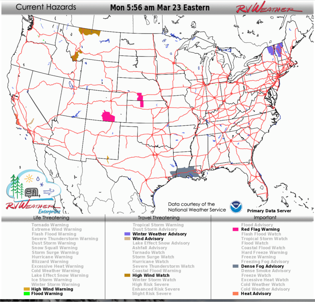
- Southern New Mexico into far west Texas. High Wind Warning early this morning, especially through Guadalupe Pass. Gusts to 60 mph producing severe crosswinds.
From the RV Mobile Command Center in Brunswick GA:
Here are the relevant National Weather Service Warnings, Watches and Advisories that will impact RV and Road travel over the next several days.
Scroll down to the always-updating graphics immediately below this forecast for the latest information and for weather impacts that do not meet NWS Alert criteria.
RV Weather’s free Weather Hub has a complete collection of always updating forecasts.
“Love the forecast? Now plan your safest route.” RV Weather’s daily forecasts keep you informed — but our SureRoute subscription gives you personalized, RV-safe routes that avoid dangerous weather and delays.
Weather Impacts Pacific Time Zone:
— Southern California corridors and mountain passes. Wind Advisory through Tuesday morning with gusts up to 55 mph creating hazardous crosswinds for high-profile vehicles. I-5, I-10 (San Gorgonio Pass), I-15 (Cajon Pass).
— South-central Oregon: Wind Advisory Tuesday with gusts to 55 mph. US-20, US-97.
— Southern California San Luis Obispo and Santa Barbara Counties: Heat Advisory today and Tuesday. High temperatures 96-104 deg F.
Weather Impacts Mountain Time Zone:
— Central and western Montana. High Wind Watches beginning Wednesday morning through evening with gusts up to 60–65 mph creating hazardous crosswinds. I-15, I-90.
— Eastern Colorado and central Plains. Red Flag Warning this afternoon through evening with dry winds and wildfire risk that may impact travel visibility. I-25, I-80.
— Southern New Mexico into far-west Texas. High Wind Warning Guadalupe Mountains and especially Guadalupe Pass early this morning with gusts up to 60 mph causing hazardous crosswinds and difficult travel for high-profile vehicles. I-10, I-20.
Weather Impacts Central Time Zone:
— Kansas and Nebraska. Red Flag Warning this afternoon through evening with increased wildfire risk and potential visibility impacts. I-80.
— Louisiana and southeast Texas. Dense Fog Advisory through late morning with near-zero visibility at times causing dangerous driving conditions. I-10, I-49, I-12, I-55.
Weather Impacts Eastern Time Zone:
— Northern New York and Vermont. Winter Weather Advisory through morning with freezing drizzle creating slick roads and very slippery travel. I-91, I-89, I-87, I-93.
— Northeast corridors. Areas of freezing rain or drizzle through morning creating slick travel conditions. I-84, I-87, I-90.
— Far-eastern Tennessee. Wind Advisory through late morning with gusts up to 45 mph creating difficult travel. I-40, I-75, I-81.
— Central Florida. Patchy dense fog through early morning reducing visibility. I-4, I-75, I-95.
“Love the forecast? Now plan your safest route.” RV Weather’s daily forecasts keep you informed — but our SureRoute subscription gives you personalized, RV-safe routes that avoid dangerous weather and delays.
Looking for real-time road conditions? Here’s a link, courtesy of the Federal Highway Administration, to all the individual State 511 websites.
Selected travel-relevant Weather Graphics


Graphics for Today


Current Severe Thunderstorm and Tornado Watches from the National Weather Service Storm Prediction Center


Hail Size Forecast for today and tomorrow

Wildfire Smoke Forecast for today and tomorrow

Graphics for Tomorrow


National Weather Map for the Day after Tomorrow

Three-day Summaries


Day 3 – Day 7 U.S. Significant Weather Outlook

Access to real-time road information:
Phone numbers and websites for road conditions in all 50 states. Courtesy of the Cheyenne WY Weather Forecast Office
Some useful links:
Thank you for using RVWeather.