


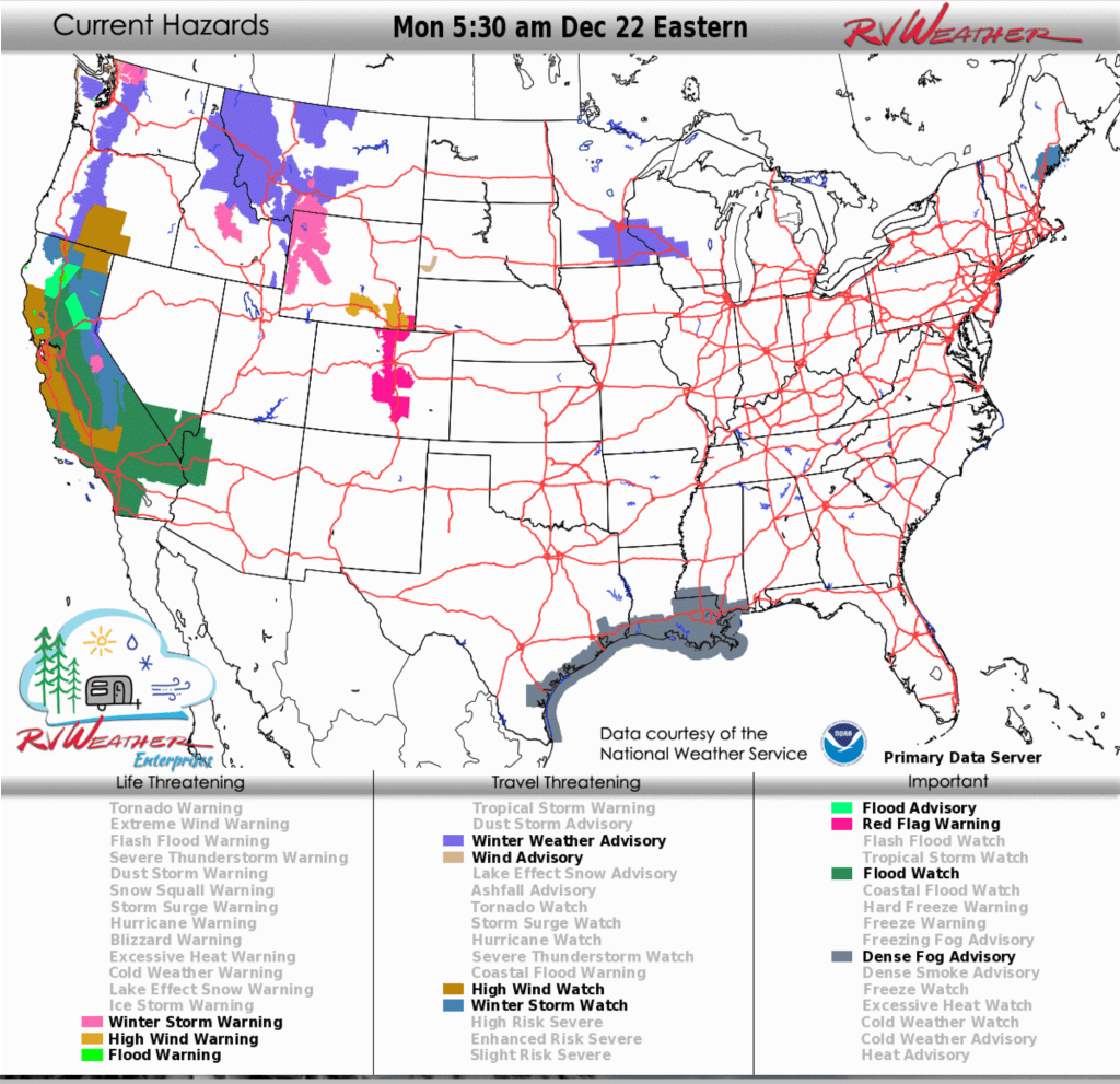
- Flood Watches through Friday: Heavy rain with embedded FLOOD WARNINGS and Advisories may cause dangerous flash flooding and widespread highway impacts across almost all of California, southern Nevada, and northwest and west-central Arizona through Friday.
- Winter Storm Warnings and Watches late tonight through Friday: Heavy mountain snow with significant accumulations and gusty winds may severely impact travel across northern and northeast California, the Sierra Nevada, and the Olympic Mountains and Cascades of Washington from late tonight through Friday.
- Sleet and freezing rain later tonight through midday Tuesday: A glaze of ice may create hazardous road conditions across far-west Maryland, much of central and northeast Pennsylvania, and the New York Southern Tier later tonight through midday Tuesday.
From the RV Weather Field Office in State College PA:
Here are the relevant National Weather Service Warnings, Watches and Advisories that will impact RV and Road travel over the next several days.
Scroll down to the always-updating graphics immediately below this forecast for the latest information and for weather impacts that do not meet NWS Alert criteria.
RV Weather’s free Weather Hub has a complete collection of always updating forecasts.
Note: The daily written forecast will transition to a weekly RV Weather Outlook beginning in January 2026. Continuously updated (free) graphics will continue.
“Love the forecast? Now plan your safest route.” RV Weather’s daily forecasts keep you informed — but our SureRoute subscription gives you personalized, RV-safe routes that avoid dangerous weather and delays.
Weather Impacts Pacific Time Zone:
— Much of the WA Pacific Coast; northern Puget Sound: Wind Advisory mid-morning through this evening. Wind gusts 40-45 mph. I-5, US-101 impacted.
— Northwest WA Olympic Mountains: Winter Weather Advisory through late this evening. Total snow accumulations 6-12 inches. Wind gusts to 40 mph. Snow levels will vary between 2000 to 2500 feet. Snow will be heaviest Monday afternoon.
— WA northern Cascades: Winter Storm Warning continues today through late this evening. Additional snow accumulations of 12 to 18 inches. Winds gusting as high as 40 mph. Snow levels will vary between 1500 to 2500 feet. Snow will be heaviest this afternoon and evening.
— Central WA Kittitas Valley: Patchy, dense freezing fog will reduce visibilities to 1 mile or less in spots through the morning hours. I-82, I-90, US-97 impacted.
— Parts of northern ID: Winter Weather Advisory continues this morning. Snow above 3500 feet. Snow accumulations 4-7 inches on Lookout Pass. I-90, US-12 impacted.
— South-central OR and northeast CA: High Wind Watch Tuesday afternoon through Wednesday morning. Wind gusts to 60 mph. US-97, US-395, CA-139 impacted.
— Northern CA I-5 corridor Shasta Valley: High Wind Watch late Tuesday afternoon and Tuesday night. Wind gusts to 60 mph. I-5, US-97 impacted.
— Much of northern and northeast CA: Winter Storm Watch late tonight through Friday. Heavy snow possible above 4500 feet in Siskiyou County. Total snow accumulations 1 to 3 feet possible, except up to 5 feet in the high terrain well above 4500 feet. Winds could gust as high as 60 mph over high and exposed terrain. Snow levels are forecast at 5000 to 6000 feet from late Monday night through Tuesday night, around 4500 feet Wednesday through Thursday, then possibly lowering to around 3500 feet Thursday night into early Friday. The heaviest precipitation is likely Tuesday night, and Wednesday night through Thursday. I-5, US-97, US-395, CA-3, CA-36, CA-44, CA-70, CA-89, CA-96, CA-139, CA-299 impacted.
— Almost all of CA; southern NV; northwest and west-central AZ: Flood Watches with embedded FLOOD WARNINGS and Advisories (Northern CA) continue through Friday. 3-7 inches of rain have already fallen over parts of Northern CA. An additional 5-8 inches of rain may fall over parts of northern CA. Heavy rain moved into southern CA by Wednesday. 3-7 inches of rain may fall in the mountains by Friday. Rainfall amounts of 2-4 inches will be common throughout the state. DANGEROUS FLASH FLOODING is possible today in northern CA and on Wednesday in southern CA. Virtually all highways will be impacted by these heavy rains.
Northern and central CA, west of I-5: High Wind Watches from north of Medocino to Big Sur. Tuesday evening through early Wednesday morning. Wind gusts 60-65 mph. US-101, CA-1 impacted.
— CA Sierra Nevada Mountains: Winter Storm Watches Tuesday evening through Friday morning. Heavy snow possible. Accumulation amounts may range from around a foot at 5500 feet and up to 3-6 feet at highest elevations. Winds could gust as high as 55 mph. Snow accumulations will remain near or above pass level through Tuesday, then drop to around 5500 feet during the day Wednesday. I-80, US-50 impacted.
— CA Sierra Nevada Yosemite National Park outside of the Valley: Winter Storm Warning through Friday afternoon. 6-8 feet of snow and wind gusts to 50 mph. Snow levels around 8,000 to 9,000 feet today, then 7,000 to 8,000 feet through Tuesday, and lowering to 6,000 feet by Christmas Day.
— Central and southern CA San Joaquin Valley and Mojave Desert Slopes: High Wind Watches Tuesday afternoon through Thursday afternoon. Wind gusts to 60 mph. I-5, CA-14, CA-33, CA-41, CA-46, CA-58, CA-152, CA-198 impacted.
— Southern CA between Long Beach and the Mexican Border; Orange County, San Bernardino Riverside County, and San Diego inland areas and Valleys; the Inland Empire: Dense Fog Advisories this morning. I-5, I-8, I-10, I-15, I-215, I-405, I-805, CA-76, CA-78, CA-79 impacted.
Weather Impacts Mountain Time Zone:
— Central and parts of northern ID; western MT: Winter Storm Warnings and Advisories continue through late this morning. Snow. There is a likelihood of developing or ongoing minor to moderate winter weather impacts. Snow accumulations of 1 to 3 inches, except 4 to 7 inches at Lookout Pass. A wintry mix may occur. I-90, US-2, US-12, US-20, US-93, US-191, US-287 impacted.
— Portions of north-central, central and south-central MT: Winter Weather Advisories through late this morning. Occasional light freezing rain or drizzle. Ice accumulations up to around a light glaze. I-15, I-90, US-2, US-12, US-87, US-89 impacted.
— Northwest MT Rocky Mountain Front: Strong winds on Monday. Wind gusts 35-50 mph. US-2, US-89 impacted.
— South-central MT Absaroka / Beartooth Mountains: Winter Storm Warnings continue today. Periods of heavy snow. Total snow accumulations of 1 to 3 feet, mainly on south and west facing slopes. Winds gusting as high as 40 mph. US-212 impacted.
— Much of northwest and west-central WY: Winter Storm Warnings continue today above 7500 feet. Heavy snow. Additional snow accumulations 4 to 8 inches. Locally higher amounts up to 15 inches. Winds gusting 35 to 55 mph. Snow levels 7000-7500 feet. US-14, US-16, US-26, US-89, US-189, US-191, US-212 impacted.
— Much of central, east-central and south-central WY: Strong winds today. Wind gusts 35-55 mph. I-25, I-80, US-18, US-20, US-26, US-85, US-287 impacted.
— Parts of southwest WY: Strong winds today. Wind gusts to 40 mph. I-80, US-30, US-189 impacted.
— Parts of southeast WY: High Wind Warnings continue through this evening. Wind gusts 60-65 mph. I-25, I-80 impacted.
— Southeast WY; much of central CO along the Front Range / I-25 corridor from the Wyoming Border to Trinidad: Red Flag (fire danger) Warnings today. Wind gusts to 40 mph. I025, I-70, I-80, US-24, US-34, US-36, US-40, US-50, US-85, US-160, US-287 impacted.
Weather Impacts Central Time Zone:
— South-central and southeast MN; central WI: Winter Weather Advisories this morning. Mixed precipitation. New snow accumulations up to half an inch and ice accumulations around a light glaze. I-35, I-39, I-41, I-43, I-90, I-94 impacted.
— Southwest and south-central SD; northwest and north-central NE: Strong winds today. Some blowing dust is possible. Wind gusts 35-50 mph. Wind Advisory west of Badlands National Park and southeast of the Black Hills. I-90, US-18, US-20, US-83, US-85 impacted.
— Northern WI: Light snow this morning. An inch or so of accumulation. US-8, US-41, US-51, US-141 impacted.
— Much of southern MS; southeast and southern LA; coastal TX; I-45 and I-37 corridors: Dense Fog Advisories this morning. I-2, I-10, I-12, I-37, I-45, I-55 ,I-59, I-69E, US-59, US-77, US-87, US-90 impacted.
Weather Impacts Eastern Time Zone:
— MI Northern Upper Peninsula: Strong winds Tuesday. Wind gusts 30-45 mph. US-41, US-45 impacted.
— NY northern and central Adirondack Mountains; northern VT: Snow this afternoon and evening. 1-3 inches accumulation. I-87, I-89, I-91, US-11 impacted.
— Central and south-central PA; far-western MD; northeast and east-central WV: Strong winds Tuesday. Wind gusts 30-45 mph. I-64, I-68, I-70, I-76, I-99, US-22, US-30, US-33, US-50, US-250 impacted.
— Far-west MD; much of central and northeast PA; NY Southern-tier: Sleet and freezing rain later tonight through midday Tuesday. A glaze of ice for most places, but north-central PA could see up to 1/10th of an inch of ice. I-68, I-70, I-76, I-78, I-80, I-81, I-84, I-86, I-88, I-99, PA Turnpike (especially Northeast Extension) impacted.
— North-central and northeast PA; northern NJ; NY; much of interior and northern New England: Snow develops late tonight, continuing through Tuesday evening. 2-4 inch accumulations will be widespread with 3-6 inches in the higher terrain. I-78, I-80, I-81, I-84, I-86, I-87, I-88, I-89, I-90, I-91, I-93, I-95, I-99 (NY), US-6, US-15, NY Thruway, PA, NJ, Mass Turnpikes impacted.
— Portions of south-central and southwest ME between Portland and Bangor: Winter Storm Watch Tuesday afternoon through Wednesday afternoon. Total snow accumulation greater than 6 inches. I-95, US-1 impacted.
“Love the forecast? Now plan your safest route.” RV Weather’s daily forecasts keep you informed — but our SureRoute subscription gives you personalized, RV-safe routes that avoid dangerous weather and delays.
Looking for real-time road conditions? Here’s a link, courtesy of the Federal Highway Administration, to all the individual State 511 websites.
Selected travel-relevant Weather Graphics


Graphics for Today


Current Severe Thunderstorm and Tornado Watches from the National Weather Service Storm Prediction Center


Hail Size Forecast for today and tomorrow

Wildfire Smoke Forecast for today and tomorrow

Graphics for Tomorrow


National Weather Map for the Day after Tomorrow

Three-day Summaries


Day 3 – Day 7 U.S. Significant Weather Outlook

Access to real-time road information:
Phone numbers and websites for road conditions in all 50 states. Courtesy of the Cheyenne WY Weather Forecast Office
Some useful links:
Thank you for using RVWeather.