


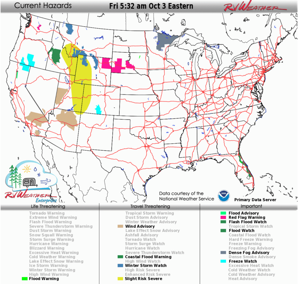
- Winter storm: Southwest Montana and northwest Wyoming are under Winter Storm Watches Saturday and Sunday, with 8–18 inches of snow possible at higher elevations.
- Strong winds: From California into the Rockies, gusts 35–55 mph today through Saturday night will create hazardous travel for RVs and other high-profile vehicles.
- Flooding rain: Florida’s east coast remains under a Flood Watch through Sunday morning, with 2–5 inches of rain likely from persistent onshore flow and a nearby tropical disturbance.
From the RV Weather Field Office in State College PA:
These are the most significant weather impacts to RV travel over the next two to three days. I do not list every area of rain, showers, or breezy winds. It would be exhausting.
Looking for real-time road conditions? Here’s a link, courtesy of the Federal Highway Administration, to all the individual State 511 websites.
Looking for wildfire smoke or hail forecasts? Click here, then scroll down to “High Resolution, Hourly Animations”. Or scroll down to the graphics below.
RV Weather’s free Weather Hub has a complete collection of always updating weather graphics and forecasts.
Weather Impacts Pacific Time Zone:
— Central WA: Red Flag (fire danger) Warning this afternoon through Saturday morning. Wind gusts to 40 mph. US-2, US-97 impacted.
— Central and northern NV: Rain, showers and embedded thunderstorms develop today and continue through late Friday. Up to an additional 1/2 to 2 inches may fall. I-80, US-50, US-93, US-95 impacted.
— Parts of south-central OR; northeast CA: Freeze Watch late tonight and Saturday morning. Low temperatures in the mid 20’s to lower 30’s° F.
— CA central Sierra Nevada Mountains above 8000 feet: Some additional snow showers today. CA-120 impacted.
— Central CA Salinas Valley: Strong winds this afternoon and evening. Wind gusts 35-45 mph. US-101 impacted.
— Southern CA Santa Barbara Coast: Wind Advisory this afternoon and tonight. Wind gusts 40-50 mph. US-101, CA-154 impacted.
— Southern CA Mojave Desert Slopes and central and southern Mojave Desert; Apple and Lucerne Valleys: Wind Advisories this afternoon and tonight. Wind gusts 45-50 mph. Strongest winds over the Mojave Desert Slopes. I-5, I-15, I-40, US-395, US-14, CA-58, CA-127, CA-138, CA-247 impacted.
— A part of southwest NV, west and northwest of Las Vegas: Wind Advisory today. Wind gusts 40-50 mph. US-95 impacted.
— Southern CA San Gorgonio Pass (I-10 near Palm Springs): Wind Advisory today and tonight. Wind gusts to 65 mph. I-10, CA-62, CA-111 impacted.
— Southern CA San Diego County Deserts and Imperial County: Wind Advisories today and tonight. Wind gusts 45-55 mph. Strongest winds along the I-8 corridor. Blowing dust may become a travel hazard. I-8, CA-78, CA-86 impacted.
— Much of southern and southeast NV: Strong winds Friday into Friday night. Wind gusts to 45 mph. I-15, US-6, US-50, US-93, US-95 impacted.
Weather Impacts Mountain Time Zone:
— Parts of west-central and central ID: Flood Watch continues through this afternoon. Heavy rainfall could trigger flooding, mud, rock and debris flows in and around burn scars. Up to an inch of rainfall expected. US-20, US-95 impacted.
— Southwest ID Treasure Valley: Strong winds tonight through late Saturday night. Wind gusts 35-50 mph. I-84, US-20, US-93, US-95 impacted.
— Parts of east-central and southeast ID; southwest MT; western WY; eastern UT; western CO: Scattered strong thunderstorms late this afternoon and evening. Severe wind gusts and hail are the primary hazards.
— Northwest MT above 5500 feet, including Glacier National Park, Going-to-the-Sun Road and Logan Pass (US-2): Winter Storm Watch Saturday night and Sunday morning. 2-6 inches of snow likely, with accumulations greater than 6 inches above 7000 feet. US-2, US-89 impacted.
— Portions of southwest MT and northwest WY, east of Yellowstone National Park: Winter Storm Watch Saturday and Sunday. 8-18 inches of snow possible. Heaviest snow accumulations will be above 8000 feet. US-14, US-16, US-191, US-212, US-287 impacted.
— WY Big Horn Mountains: Winter Storm Watch Saturday evening through Sunday afternoon. 7-14 inches of snow possible. Wind gusts to 30 mph. Heaviest snow accumulations will occur above 8000 feet. US-14, US-14A, US-16 impacted.
— Northeast WY: Red Flag (fire danger) Warning today. Wind gusts 25-35 mph and afternoon relative humidity 10-15%. I-90, US-18 impacted.
— Central, south-central and southwest WY; western CO; much of UT; northern and central AZ: Strong winds through late this evening. Wind gusts to 45 mph. I-15, I-17, I-25, I-40, I-70, I-80, US-6, US-20, US-26, US-40, US-50, US-89, US-160, US-180, US-191, US-287 US-491 impacted.
— Central and south-central WY; most of CO; eastern UT; northeast and east-central AZ; western, central and northern NM: Strong winds Saturday into Saturday night. Wind gusts 35-50 mph. I-25, I-40, I-70, I-80, US-24, US-34, US-36, US-40, US-50, US-60, US-64, US-84, US-87, US-160, US-191, Us-285, US-287, US-385, US-491, US-550 impacted.
— West-central and southwest UT: Wind Advisories mid-morning through this evening. Wind gusts to 55 mph. I-15, US-6, US-50 impacted.
— Much of eastern CO; northeast NM: Strong winds this evening into Sunday night. Wind gusts to 45 mph. I-25, I-70, US-34, US-36, US-40, US-50, US-64, US-87, US-160, US-287, US-385 impacted.
— South-central CO: Freeze Watch late Saturday night and Sunday morning. Low temperatures in the mid to upper 20’s° F.
— Much of central and north-central AZ: Wind Advisories midday today through this evening. Wind gusts to 45 mph. I-17, I-40, US-89, US-160, US-180 impacted.
Weather Impacts Central Time Zone:
— Parts of southwest and central SD: Red Flag (fire danger) Warnings through this evening. Wind gusts 35-40 mph. I-90, US-14, US-18, US-83 impacted.
— Western and north-central SD; much of ND: Rain, rain showers and embedded thunderstorms Saturday night through Sunday. 1/2 to 2 inches of rainfall expected.
— Southeast ND; central and eastern SD; central and southwest NE; western KS: Strong winds develop midday today and continue into Sunday. Wind gusts to 45 mph. Strongest winds Saturday afternoon and evening. I-29, I-70, I-80, I-90, I-94, US-12, US-14, US-18, US-20, US-34, US-36, US-40, US-50, US-52, US-83, US-160, US-212, US-281 impacted.
— Northwest MN; southeast ND; central and eastern SD; north-central and southwest NE: Strong thunderstorms possible late Saturday afternoon or evening, with some risk for severe wind gusts and hail. I-29, I-80, I-90, I-94, US-2, US-10, US-12, US-14, US-18, US-20, US-26, US-75, US-83 potentially impacted.
— Northeast MN: Dense Fog Advisories this morning. US-2, US-53, US-71, US-169, MN-61 impacted.
— Coastal southeast LA; coastal southwest MS (Hancock County): Coastal Flood Advisories this afternoon through Sunday evening. Minor coastal flooding expected. Isolated road closures possible.
— Gulf Coast from southeast LA to Apalachicola FL: Strong winds this afternoon through Saturday night. Wind gusts 30-40 mph along the immediate coast. US-90, US-98 impacted.
Weather Impacts Eastern Time Zone:
— Parts of Chesapeake Bay; portions of coastal NC: Coastal Flood Advisories remain in effect through this evening. A few places will see up to 1-2 feet of tidal inundation. Some low-lying coastal roads and campgrounds may be impacted.
— Southern SC, GA, northeast FL coasts: Strong winds today through Saturday night. Wind gusts to 40 mph. Continued high surf, rip currents, enhanced high tides, and localized coastal flooding.
— Southern GA coast; northeast FL coast and St. John’s River Basin: Coastal Flood Warnings and Advisories through Monday morning. Significant Flooding possible. Numerous roads may be closed.
— Much of the FL east coast: Flood Watch through Sunday morning. Persistent onshore winds and a nearby tropical disturbance will cause numerous showers and a few lightning storms to develop through the end of the week. A total of 2-5 inches of rainfall will be common. I-4, I-95, US-1 impacted.
Selected travel-relevant Weather Graphics


Graphics for Today


Current Severe Thunderstorm and Tornado Watches from the National Weather Service Storm Prediction Center


Hail Size Forecast for today and tomorrow

Wildfire Smoke Forecast for today and tomorrow

Graphics for Tomorrow


National Weather Map for the Day after Tomorrow

Three-day Summaries


Day 3 – Day 7 U.S. Significant Weather Outlook

Access to real-time road information:
Phone numbers and websites for road conditions in all 50 states. Courtesy of the Cheyenne WY Weather Forecast Office
Some useful links:
Thank you for using RVWeather.