


- Scattered Severe Thunderstorms Saturday: Tornadoes, damaging winds, and hail possible across southern Missouri, Arkansas, and the mid-Mississippi Valley.
- Heavy Rain and Thunderstorms Saturday into Sunday: Rainfall of one-half to two inches from Arkansas and Missouri through Illinois, Michigan, Indiana, and Ohio may cause localized flash flooding, especially in southern Missouri and southern Illinois.
- Strong Winds Today into Saturday: Widespread gusts of 30–50 mph from the northern Plains through the central Rockies and into western Montana will create challenging driving conditions on I-25, I-70, I-80, I-90, and I-94.
From the RV Weather Field Office in State College PA:
These are the most significant weather impacts to RV travel over the next two to three days. I do not list every area of rain, showers, or breezy winds. It would be exhausting.
Looking for real-time road conditions? Here’s a link, courtesy of the Federal Highway Administration, to all the individual State 511 websites.
Looking for wildfire smoke or hail forecasts? Click here, then scroll down to “High Resolution, Hourly Animations”. Or scroll down to the graphics below.
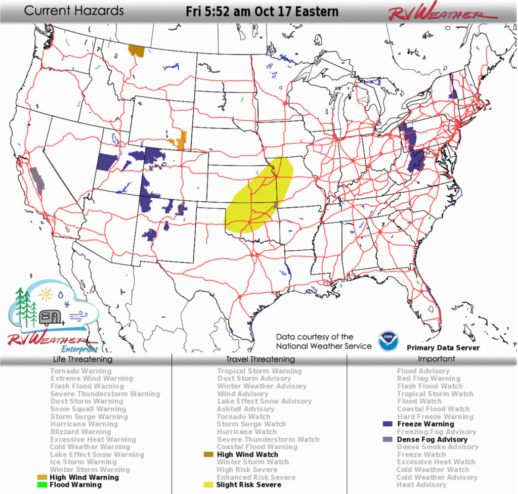
RV Weather’s free Weather Hub has a complete collection of always updating weather graphics and forecasts.
Weather Impacts Pacific Time Zone:
— Western WA northern Puget Sound; coastal WA and northern coastal OR: Strong develop Saturday night. Wind gusts to 40 mph. I-5, US-101 impacted.
— Western WA; northwest OR: Rain, some heavy, spreads across this region Saturday afternoon through Sunday evening. 1-3 inches of rainfall along the coast and 3 or more inches of rain on western-facing Olympic and Cascade mountains. I-5, I-84, I-90, US-2, US-12, US-26, US-30, US-101 impacted.
— Central WA Kittitas Valley; north-central OR Columbia Gorge: Strong winds this afternoon. Wind gusts 30-35 mph. I-82, I-84, I-90 impacted.
— Central and southern CA San Joaquin Valley south of Modesto: Dense Fog Advisory through mid-morning. Dense fog mostly east of the I-5 corridor. CA-41, CA-99, CA-140, CA-152, CA-180, CA-198 impacted.
Weather Impacts Mountain Time Zone:
— Western and south-central MT; northwest, central and southeast WY: A band of snow moves across this region from the northwest to the southeast this afternoon through early Saturday morning. Snow levels 6500-7000 feet. 1-3 inches on the higher passes. I-80, US-2, US-12, US-14, US-16, US-26, US-87 impacted.
— North-central MT: High Wind Watch late Saturday night through Sunday evening. Wind gusts to 60 mph. I-15, US-2 impacted.
— Northwest, central and eastern MT; northwest and central WY: Strong winds through Saturday morning. Strong winds continue across southeast WY on Saturday. Wind gusts generally 35-50 mph. I-90, I-94, US-2, US-12, US-14, US-16, US-18, US-20, US-26, US-89, US-212, US-287 impacted.
— Southeast WY: High Wind Warnings continue through early Saturday morning. Wind gusts to 60 mph. A brief lull in winds is expected between noon and 6pm on Friday. I-25, I-80 impacted.
— Much of north-central, northeast and east-central CO: Strong winds on Saturday. Wind gusts 30-40 mph east of I-25 and 35-50 mph in the Rockies. I-25, I-70, I-76, US-6, US-24, US-34, US-36, US-40, US-385 impacted.
Weather Impacts Central Time Zone:
— Much of ND; northwest MN; northern and western SD: Strong winds today. Wind gusts generally 30-45 mph. I-29, I-90, I-94, US-2, US-12 US-14, US-16, US-18, US-52, US-83, US-85, US-212 impacted.
Most of ND and SD; central and western NE; western and north-central KS: Strong winds on Saturday. Wind gusts 30-45 mph. I-70, I-80, I-90, I-94 impacted.
— Eastern and south-central KS; western MO; much of central and eastern OK: Severe thunderstorms with isolated hail and strong to severe wind gusts will be possible this evening through the overnight period. I-29, I-35, I-40, I-44, I-49, I-70 potentially impacted.
— Central and southern IL; eastern, central and southern MO; eastern OK; AR; eastern TX; LA along and north of I-10; most of MS; western and northern AL; western and central KY and TN: Scattered severe thunderstorms will be possible Saturday. These storms will pose a threat for tornadoes, damaging wind gusts and hail. Greatest likelihood of severe thunderstorms will be across southern MO, AR, and the mid-Mississippi Valley. I-10, I-20, I-22, I-24, I-30, I-35, I-40, I-44, I-45, I-49, I-55, I-57, I-59, I-64, I-65, I-70, I-72, I-74 potentially impacted.
— IL; eastern, central and southern MO; AR; western and central KY and TN; northern LA; northern and central MS and AL: Rain, rain showers and thunderstorms, some heavy, develop Saturday afternoon across AR and MO, then spread across the Mississippi Valley and IL by Saturday evening. Expect rainfall amounts of 1/2 to 2 inches by Sunday morning. Greatest chance for flash flooding will be across southern MO and southern IL. I-20, I-22, I-24, I-30, I-40, I-44, I-49, I-55, I-57, I-64, I-65, I-69, I-70, I-72, I-74, I-80 impacted.
Weather Impacts Eastern Time Zone:
— Cape Cod MA: Strong winds continue today. Wind gusts to 40 mph. US-6 impacted.
— Much of IN; western and central OH; central KY: Scattered severe thunderstorms will be possible Saturday. These storms will pose a threat for tornadoes, damaging wind gusts and hail. I-64, I-65, I-69, I-70, I-71, I-74, I-75, I-77, I-80, I-90, OH Turnpike, IN Toll Road potentially impacted.
— Central and southern MI; IN; northern and western OH; central KY: Rain, rain showers and thunderstorms, some heavy, develop Saturday afternoon and continue through Sunday evening. Rain fall amounts of 1-3 inches will be common, especially across MI and IN. I-64, I-65, I-69, I-70, I-71, I-74, I-75, I-77, I-80, I-90, I-94, I-96, IN Toll Road, OH Turnpike impacted.
— Most of OH; eastern KY; western NY; central and western PA; western MD; WV: Severe thunderstorms with a threat mainly for damaging winds are possible on Sunday. I-64, I-68, I-70, I-71, I-75, I-76, I-77, I-79, I-80, I-81, I-86, I-90, I-99, OH and PA Turnpikes, NY Thruway potentially impacted.
Selected travel-relevant Weather Graphics


Graphics for Today


Current Severe Thunderstorm and Tornado Watches from the National Weather Service Storm Prediction Center


Hail Size Forecast for today and tomorrow

Wildfire Smoke Forecast for today and tomorrow

Graphics for Tomorrow


National Weather Map for the Day after Tomorrow

Three-day Summaries


Day 3 – Day 7 U.S. Significant Weather Outlook

Access to real-time road information:
Phone numbers and websites for road conditions in all 50 states. Courtesy of the Cheyenne WY Weather Forecast Office
Some useful links:
Thank you for using RVWeather.