


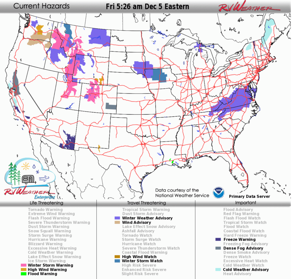
- Major snowstorm: Significant valley and mountain snow with gusts to 45 mph will impact much of the central and northern Rockies into Sunday.
- Winter Weather Advisories: A mixture of snow, sleet and freezing rain with 1–2 inches of snow for most locations and 2–4 inches in the mountains will affect the Mid-Atlantic and central Appalachians today and tonight.
- High winds: Widespread strong to high winds with gusts ranging from 35–65 mph will impact the Pacific Northwest, Rockies and the western High Plains.
From the RV Weather Field Office in State College PA:
Here are the relevant National Weather Service Warnings, Watches and Advisories that will impact RV and Road travel over the next several days.
Scroll down to the always-updating graphics immediately below this forecast for the latest information and for weather impacts that do not meet NWS Alert criteria.
RV Weather’s free Weather Hub has a complete collection of always updating forecasts.
“Love the forecast? Now plan your safest route.” RV Weather’s daily forecasts keep you informed — but our SureRoute subscription gives you personalized, RV-safe routes that avoid dangerous weather and delays.
Weather Impacts Pacific Time Zone:
— WA northern Cascades: Winter Weather Advisory this evening into Saturday night. Snow expected. 5-10 inches at Stevens Pass. Wind gusts to 35 mph. Snow levels 5000 feet this evening, falling to 4000 feet by Saturday morning. US-2 impacted.
— North-central and northeast WA: Snow this afternoon and evening. 1-4 inches accumulation. US-2, US-395 impacted.
— Central, south-central and southeast WA; northwest ID; north-central and northeast OR: High Wind Warnings (central WA) and Advisories this evening into Saturday morning. Wind gusts 50-65 mph. I-82, I-84, I-90, US-2, US-12, US-26, US-95, US-97, US-395 impacted.
— Most of OR east of the Cascades: Strong winds develop this afternoon and continue into midday Saturday. Wind gusts 35-50 mph. I-84, US-20, US-26, US-95, US-97, US-395 impacted.
— Northeast NV: Strong winds tonight into Saturday. Wind gusts 35-45 mph. I-80 impacted.
— Northern and central CA: Dense Fog Advisories through late this morning for much of the Sacramento Valley, Delta Region and East Bay. Fog extends from Redding to Modesto. I-5, I-80, I-505, US-50, CA-99 impacted.
— Central CA San Francisco East Bay; Monterey Bay: Coastal Flood Advisories through Sunday. Up to 1-2 feet of inundation above ground level is possible in low lying areas near shorelines and tidal waterways. Flooding of lots, parks, and roads with only isolated road closures expected.
Weather Impacts Mountain Time Zone:
— Most of ID north of I-84; ; western and central MT; western WY; north-central WY (Big Horn Range); southeast ID; north-central and central UT: Major snowstorm expected. A combination of Winter Storm Warnings, Watches and Advisories continue into Sunday. 4-8 inches of snow in the valleys and 1-3 feet in the mountains and across the higher passes. Wind gusts to 45 mph. I-15, I-70, I-80, I-84, I-90, US-2, US-6, US-12, US-14, US-16, US-20, US-26, US-30, US-40, US-89, US-91, US-189, US-191, US-212, US-287 impacted.
— North-central and northeast MT: Winter Weather Advisories this evening through midday Saturday. 2-4 inches of snow expected. I-94, US-2, US-87 impacted.
— Southeast WY: High Wind Warnings continue through midday today. Wind gusts to 65 mph. I-25, I-80, US-287 impacted.
— South-central WY; much of north-central and central CO: Winter Storm Warnings (WY) and Watches into Saturday night. Snow amounts will range from 6 inches to 2 feet. Wind gusts 35-65 mph. I-70, I-80, US-24, US-34, US-40, US-50, US-285 impacted.
— Southeast CO: Dense Fog Advisory early this morning. US-50 impacted.
— South-central CO; central NM; east-central NM: Strong winds Saturday. Wind gusts 35-50 mph. I-25, I-40, US-24, US-50, US-60, US-64, US-70, US-82, US-84, US-160, US-285
— Central NM: Strong winds today. Wind gusts to 40 mph. I-25, I-40, US-54, US-60, US-70, US-84, US-285 impacted.
— Southeast NM and adjacent west TX Guadalupe Mountains: High Wind Warning through this evening. Wind gusts to 60 mph. US-62 impacted.
Weather Impacts Central Time Zone:
— Western and south-central SD; adjacent northwest and north-central NE: Strong winds today. Wind gusts 35-45 mph. I-90, US-18, US-20, US-85 impacted.
— Southwest SD; western NE: Strong winds Saturday afternoon. Wind gusts 35-45 mph. I-80, US-18, US-20, US-26, US-385 impacted.
— Southeast SD; southwest MN; central and northwestern IA: Winter Storm Watches and Advisories Saturday and Saturday night. 2-7 inches of snow likely; heaviest amounts in IA. I-29, I-35, I-80, I-90, US-14, US-20, US-69, US-71, US-75, US-81 impacted.
— Portions of southwest TX Panhandle and west TX around and north of the I-10/I-20 split: Strong winds Saturday afternoon. Wind gusts to 35 mph. I-10, I-20, I-27, US-60, US-62, US-84 impacted.
Weather Impacts Eastern Time Zone:
— Northeast MI Upper Peninsula: Winter Weather Advisories continue this morning. Total snow accumulations between 2 and 4 inches. Winds gusting up to 40 mph will result in considerable blowing and drifting of snow. I-75, US-41 impacted.
— Northeast TN; eastern KY; eastern WV; much of VA (except Tidewater); southeast MD; much of northern and western NC: Winter Weather Advisories continue today and tonight. A mixture of snow, sleet and freezing rain will move southwest to northeast across the region. Snowfall will be 1-2 inches in most places but up to 2-4 inches in the mountains. Many locations will see a light glaze of ice. I-26, I-40, I-64, I-66, I-73, I-74, I-75, I-77, I-81, I-85, I-95, US-13, US-15, US-17, US-29, US-50, US-58 impacted.
“Love the forecast? Now plan your safest route.” RV Weather’s daily forecasts keep you informed — but our SureRoute subscription gives you personalized, RV-safe routes that avoid dangerous weather and delays.
Looking for real-time road conditions? Here’s a link, courtesy of the Federal Highway Administration, to all the individual State 511 websites.
Selected travel-relevant Weather Graphics


Graphics for Today


Current Severe Thunderstorm and Tornado Watches from the National Weather Service Storm Prediction Center


Hail Size Forecast for today and tomorrow

Wildfire Smoke Forecast for today and tomorrow

Graphics for Tomorrow


National Weather Map for the Day after Tomorrow

Three-day Summaries


Day 3 – Day 7 U.S. Significant Weather Outlook

Access to real-time road information:
Phone numbers and websites for road conditions in all 50 states. Courtesy of the Cheyenne WY Weather Forecast Office
Some useful links:
Thank you for using RVWeather.