


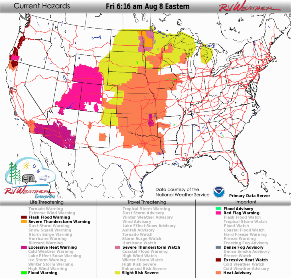
- Scattered severe thunderstorms may produce damaging winds, large hail, a tornado or two, and heavy rain across parts of the Upper Midwest, mainly later today, tonight and Saturday.
- Very hot temperatures will continue through today across the Desert Southwest, which could break daily high temperature records.
- Strong winds today for much of the northern and central Rockies.
From the RV Weather Field Office in Moran WY:
These are the most significant weather impacts to RV travel over the next two to three days. I do not list every area of rain, showers, or breezy winds. It would be exhausting.
Looking for real-time road conditions? Here’s a link, courtesy of the Federal Highway Administration, to all the individual State 511 websites.
Looking for wildfire smoke or hail forecasts? Click here, then scroll down to “High Resolution, Hourly Animations”. Or scroll down to the graphics below.
RV Weather’s Weather Hub has a complete collection of always updating weather graphics and forecasts.
Weather Impacts Pacific Time Zone:
— Western OR, east of the coastal range; adjacent northwest CA: Extreme Heat Watch Sunday and Monday. High temperatures 90-105°F. I-5, I-84 impacted.
— Central CA coast south of Big Sur to north of Santa Barbara: Dense Fog Advisory this morning. US-101, CA-1 impacted.
— Southern CA Mojave Desert Slopes: Strong winds this afternoon and evening, and again Saturday afternoon and evening. Wind gusts 30-40 mph. US-395, CA-14, CA-58 impacted.
— Southeast CA Deserts: Extreme Heat Warning continues today. Major heat risk with high temperatures 107-115° F. I-8, I-10, I-40 impacted.
— Southwest CA except along the immediate coast: Heat Advisories today. High temperatures may reach 95-102° F.
— Southern CA coast from Big Sur to Santa Barbara: Dense Fog Advisories this morning. US-101, CA-1 impacted.
Weather Impacts Mountain Time Zone:
— Parts of northwest, central and south-central MT; northwest WY: Strong winds today through late this evening. Wind gusts to 45 mph. Some gusts in excess of 50 mph possible on I-90 near Livingston MT. I-15, I-90, US-2, US-12, US-14, US-16, US-26, US-87, US-89, US-212 impacted.
— Much of north-central and eastern MT: Strong winds Saturday. Wind gusts to 40 mph. I-94, US-2, US-12, US-87 impacted.
– Much of central and southern WY along and west of I-25: Red Flag (fire danger) Warnings today. Wind gusts to 40 mph. I-25, I-80, US-20, US-26, US-30, US-89, US-191, US-287 impacted.
– Southwest and eastern UT; western and central CO: Red Flag (fire danger) Warnings today and again on Saturday. Wind gusts to 40 mph. I-15, I-70, US-6, US-24, US-40, US-50, US-89, US-160, US-191, US-285, US-491, US-550 impacted.
— Portions of south-central and southeast CO: Heat Advisories are in effect tomorrow afternoon. Temperatures up to 107°F are expected. I-25, US-50, US-287 impacted.
— Central and eastern CO: Isolated severe thunderstorms possible Saturday. Wind gusts and hail are the primary hazards.
– Lower Elevations of the Grand Canyon: Extreme Heat Warning continues through Tuesday for elevations below 4000 feet. Daytime temperatures 102-116°F expected.
– Southern and western AZ: Extreme Heat Warnings continue today. High temperatures 107-112°F. I-8, I-10, I-19, I-40, US-60, US-70, US-93, US-95, US-191 impacted.
— Portions of central and southeast NM, including Albuquerque; far-southwest TX: Heat Advisories today and Saturday. High temperatures around 105° F.
Weather Impacts Central Time Zone:
— Eastern ND and SD; northeast NE; much of MN; northwest WI: Scattered severe thunderstorms are possible later today and tonight. Thunderstorms may contain scattered damaging wind gusts, large hail and a couple of tornadoes. I-29, I-35, I-90, I-94, US-2, US-8, US-10, US-12, US-14, US-52, US-53, US-81 potentially impacted.
— Portions of east-central and northwest WI; southern MN; southeast SD; much of IA; northwest IL; southern, central and eastern NE; much of KS; western MO; most of OK; northwest AR; northwest and north-central TX: Heat Advisories today. Heat index values 105° F in the north to 110° F in the south.
— Western ND and SD; south-central SD: Strong winds today. Wind gusts 30-35 mph. I-90, I-94, US-2, US-12, US-14, US-16, US-83, US-85 impacted.
ND; northwest and north-central SD; northwest MN: Strong winds Saturday. Wind gusts to 45 mph. I-29, I-94, US-2, US-12, US-52, US-83, US-85 impacted.
— Portions of western OK; south-central and east-central KS: Strong winds this afternoon. Wind gusts around 30 mph. I-35, I-135, I-40, I-70 impacted.
— Northeast IA; southwest, central and northeast WI: Isolated severe thunderstorms possible on Saturday. Heavy rainfall with 1-4 inches of rain possible across WI. I-39, I-43, I-90, I-94, US-19, US-45, US52, US-61 potentially impacted.
— East-central KS; northern MO: A few strong thunderstorms may develop on Sunday. I-35, I-70 potentially impacted.
Weather Impacts Eastern Time Zone:
— MI Upper Peninsula: Heavy rain showers and thunderstorms tonight and Saturday. Rainfall amounts may exceed 1 inch. I-75, US-2, US-41, US-45 impacted.
— Generally pleasant weather across much of the Northeast, central Appalachians and Mid-Atlantic through the weekend. today. Some showers possible this afternoon across the NY Adirondack and VT and NH Green and White Mountains. Some wildfire smoke will persist north of I-20.
Selected travel-relevant Weather Graphics


Graphics for Today


Current Severe Thunderstorm and Tornado Watches from the National Weather Service Storm Prediction Center


Hail Size Forecast for today and tomorrow

Wildfire Smoke Forecast for today and tomorrow

Graphics for Tomorrow


National Weather Map for the Day after Tomorrow

Three-day Summaries


Day 3 – Day 7 U.S. Significant Weather Outlook

Access to real-time road information:
Phone numbers and websites for road conditions in all 50 states. Courtesy of the Cheyenne WY Weather Forecast Office
Some useful links:
Thank you for using RVWeather.