


Planning to travel today or this week? Here’s what could impact your route – and what you should do.
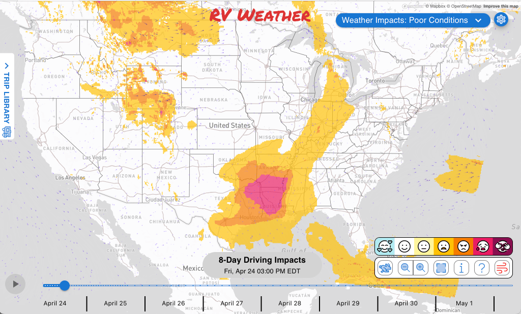
- Severe thunderstorms from Texas to the Midwest each day, continuing throughout the weekend and into Monday.
- Marginally severe thunderstorms possible today across parts of the lower Ohio Valley and southern Great Lakes.
- Snow and winter driving conditions continue through Saturday morning across Montana and the northern Rockies.
What this means for your trip
- If traveling across Oklahoma, Arkansas, Texas, Kansas, and the lower Mississippi Valley between now and Monday, make sure you have a way to get National Weather Service thunderstorm and tornado warnings in real-time.
- Mountain routes in Montana, northern Wyoming, and north-central Idaho may require slower travel or a delay until snow-covered roads improve, which will happen starting Saturday.
- If you’re crossing southern California desert passes Saturday afternoon through Sunday morning, consider adjusting timing to avoid the strongest crosswinds and blowing dust. Strongest winds expected Saturday evening.
Your route’s weather may vary from the general forecast — check your exact trip
48-hour access • No credit card required
Risk free – 30-day money-back guarantee
Want a deeper look at conditions?
Below are the significant weather alerts and travel impacts across the country:
Weather Impacts Pacific:
— Lewiston-Clarkston area and central Washington Columbia Basin: Freeze Watch late tonight through Saturday morning with sub-freezing temperatures as low as 29 to 30 degrees possible.
— Western Mojave Desert, Morongo Basin, Apple and Lucerne Valleys, and San Gorgonio Pass: Wind Advisory beginning Saturday afternoon through Sunday morning with southwest winds 25 to 35 mph, gusts 45 to 55 mph, and local gusts up to 60 mph near desert slopes and passes. Hazardous crosswinds and areas of blowing dust may make travel difficult for high-profile RVs. I-10, I-15, I-40, CA-14, CA-58, and US-395.
Weather Impacts Mountain:
— Idaho Snake River Plain and nearby valleys: Freeze Watch late Friday night through Saturday morning with sub-freezing temperatures of 28 to 32 degrees possible.
— North-central Idaho into western Montana: Winter Weather Advisory through midday with additional snow accumulations generally 1 to 6 inches, locally up to 8 inches in western Montana mountain areas. Slick roads and slower travel are likely, especially over passes and higher terrain. I-90, US-12, US-93, US-95, and I-15.
— Northern and north-central Montana: Winter Weather Advisory through Saturday midday with snow accumulations of 1 to 3 inches. Expect slick roads and slower travel, especially during morning and nighttime travel windows. I-15, I-94, US-2, US-87, and US-191.
— Gallatin, Madison, and Centennial Mountains: Winter Storm Warning through midday with additional snow accumulations of 3 to 6 inches. Roads, bridges, and overpasses may become slick and hazardous. US-191.
— Absaroka/Beartooth Mountains: Winter Storm Warning through early evening with additional snow accumulations of 3 to 7 inches and gusts as high as 35 mph. Snow and blowing snow may reduce visibility and make high-country travel difficult. US-89 and US-212.
— Central and southwest Montana: Winter Weather Advisory through midday with 1 to 3 inches at lower elevations, up to 6 inches in the mountains, and wind gusts as high as 35 mph. Slick roads and reduced visibility may affect mountain travel. I-15, I-90, US-12, US-89, and US-191.
— South-central Montana into northern Wyoming mountains: Winter Weather Advisory through early evening with additional snow accumulations of 2 to 8 inches and wind gusts to 35 mph. Mountain roads and passes may be snow-covered with slower travel. The heaviest snow is expected to fall this morning. US-14 and US-212.
— Colorado, southeast Wyoming, and the Nebraska Panhandle: Red Flag Warning from late morning through this evening with southwest to west winds gusting 25 to 45 mph, very low humidity, and rapid fire spread possible. Dry, gusty crosswinds and wildfire risk may affect exposed routes. I-25, I-70, I-76, I-80, and US-40.
— West El Paso and far southern New Mexico: Flood Watch through late tonight due to possible flooding caused by a potential break of the Cement Lake Dam. Roads in low-lying areas could become flooded or restricted. Low water levels in the Rio Grande will mitigate impacts. Highways near I-10, I-25, US-70, and US-180 may be impacted.
Weather Impacts Central:
— Northern Wisconsin near Ashland and Bayfield Counties: Flood Advisory through this morning with minor flooding in low-lying and poor-drainage areas. Local roads may have standing water. US-2.
— Northwest Arkansas and eastern Oklahoma: Flood Advisory through this morning with flooding from excessive rainfall expected. Estimates of up to 1.5 inches of rain have fallen. – Additional rainfall amounts of 0.5 to 1.5 inches are expected over the area. Water may cover low spots and poor-drainage roads. Highways near I-44, I-49, US-62, US-69, and US-412 may be impacted.
— Central and eastern Texas, central and eastern Oklahoma, Arkansas, Louisiana, Mississippi, western/central Alabama, western/central Tennessee, southern Missouri, southern Kentucky, and southern Illinois: Scattered severe thunderstorms are expected today, with large hail, damaging winds, and a few tornadoes possible; isolated strong wind gusts may also occur farther north toward the lower Ohio Valley and southern Great Lakes. The greatest risk of severe weather will be across much of Mississippi, much of Arkansas, northeastTexas, southeast Oklahoma, and much of Louisiana. I-10, I-20, I-22, I-30, I-35, I-40, I-45, I-49, I-55, and I-59 potentially impacted.
— Central and northeastern Texas, Oklahoma, Kansas, Arkansas, southwest Missouri, and northwest Louisiana: One or two clusters of strong to severe thunderstorms are possible Saturday afternoon and evening, with large hail and damaging wind gusts the main hazards. The greatest risk of severe weather will be from central/eastern Oklahoma into western Arkansas and southern Kansas. I-10, I-20, I-30, I-35, I-40, I-44, I-49, and I-70 potentially impacted.
— Southeast South Dakota, Nebraska, Kansas, Oklahoma, central and northeastern Texas, western and central Iowa, Missouri, Arkansas, northern Louisiana, central and northern Mississippi, and far-southwest Tennessee: Widely scattered severe storms are possible Sunday afternoon into early evening, with large hail and a couple of strong tornadoes possible before organizing clusters spread toward the middle and lower Missouri Valley with damaging wind gusts. The greatest risk of severe weather will be across much of Kansas, northern Oklahoma, central/northern Missouri, and southern Nebraska. I-10, I-20, I-29, I-35, I-40, I-44, I-49, I-55, I-70, and I-80 potentially impacted.
Weather Impacts Eastern:
— Michigan central and western Upper Peninsula: Flood Advisory through Monday afternoon and Flood Watch through Saturday morning due to river flooding, rain, and snowmelt. Low-lying roads and river crossings may flood or become restricted. Highways near US-2, US-41, and US-45 may be impacted.
— Much of Indiana, central and western Ohio, southern Michigan Lower Peninsula, and north-central Kentucky: A few severe thunderstorms are possible today, with isolated strong wind gusts the main concern. Brief hazardous driving conditions may occur in stronger storms. I-64, I-65, I-69, I-70, I-71, I-75, I-94, and I-96 potentially impacted.
— Central Georgia: Dry fire-weather conditions this afternoon into evening. Avoid stopping over dry grass and expect elevated wildfire risk near open or rural routes. I-16, I-20, I-75, US-1, and US-23.
— Southeast Georgia: Dense Smoke Advisory through midday with visibility one-quarter mile or less possible in dense smoke. Hazardous low-visibility driving may occur on affected local routes. US-25 and US-84.
Looking for real-time road conditions? Here’s a link, courtesy of the Federal Highway Administration, to all the individual State 511 websites.
Your route’s weather may vary from the general forecast — check your exact trip
48-hour access • No credit card required
Risk free – 30-day money-back guarantee
Selected travel-relevant Weather Graphics


Graphics for Today


Current Severe Thunderstorm and Tornado Watches from the National Weather Service Storm Prediction Center


Hail Size Forecast for today and tomorrow

Wildfire Smoke Forecast for today and tomorrow

Graphics for Tomorrow


National Weather Map for the Day after Tomorrow

Three-day Summaries


Day 3 – Day 7 U.S. Significant Weather Outlook

Access to real-time road information:
Phone numbers and websites for road conditions in all 50 states. Courtesy of the Cheyenne WY Weather Forecast Office
Some useful links:
Thank you for using RVWeather.