
- Slight risk of severe thunderstorms with damaging wind gusts today across portions of the Northeast and Mid-Atlantic States.
- One more hot day along the Eastern Seaboard.
- Heat returns to the West by the end of the week; widespread critical wildfire conditions.
From the RV Weather Field Office in State College PA:
These are the most significant weather impacts to RV travel over the next two to three days. I do not list every area of rain, showers, or breezy winds. It would be exhausting (for both of us!).
Weather Impacts Pacific Time Zone:
— WA Olympic Range; much of WA east of the Coastal Ranges; northwest, north-central and central OR east of the Coastal Ranges: Red Flag Warnings today for abundant lightning. Although winds will be light conditions are such that any new fire starts may exhibit extreme fire behavior. I-5, I-82, I-84, US-2, US-12, US-20, US-26, US-97, US-395 potentially impacted.
— Much of central and eastern WA; north-central OR: Heat Advisories today through Thursday. High temperatures 95 – 105 deg F.
— East-central and southeast OR: Excessive Heat Watch Thursday through next Tuesday. High temperatures could reach 110 deg F. I-84, US-20, US-95 impacted.
— Southern CA foothills and mountains away from the coast and north of Los Angeles: Excessive Heat Watches Friday through Wednesday. High temperatures 95-110 deg F.
— Southern CA Coastal Santa Barbara County: Wind Advisory this evening and tonight. Wind gusts 45-50 mph. US-101, CA-1 impacted.
— Southern and southeast CA interior deserts, including the Mojave Desert and Death Valley National Park; southern NV: Excessive Heat Watches Friday through Sunday. High temperatures 107 – 118 deg F with temperatures well above 120 deg F in Death Valley NP.
Weather Impacts Mountain Time Zone:
— Portions of southern ID: Red Flag (fire danger) Warning this afternoon and evening for scattered thunderstorms. Wind gusts may approach 50 mph in thunderstorm outflow regions. I-84, US-93 potentially impacted.
— Southwest ID along the I-84 corridor: Excessive Heat Watch Thursday through next Tuesday. High temperatures could reach 110 deg F. I-84, US-26, US-93 impacted.
— East-central and southeast WY; eastern CO; northeast NM: Isolated strong to severe thunderstorms are possible today. Wind gusts and hail will be the primary hazards. I-25, I-40, I-70, I-76, I-80, I-90 potentially impacted.
— Far-eastern WY; eastern CO; northeast NM : Isolated strong to severe thunderstorms are possible on Thursday. Wind gusts and hail will be the primary hazards. I-70, I-76, I-80, I-90 potentially impacted.
— Southwest UT; western and portions of south-central AZ: Excessive Heat Watches Friday and Saturday. High temperatures 110-117 deg F.
— Much of central, north-central and east-central NM: Flood Watches this afternoon through late tonight. Flash flooding may be caused by an increase in the number and intensity of showers and thunderstorms. I-25, I-40, US-54, US-60, US-64, US-70, US-84, US-285, US-380 potentially impacted.
Weather Impacts Central Time Zone:
— Southwest SD; western NE; western KS; western OK Panhandle; northwest TX Panhandle: Isolated strong to severe thunderstorms are possible today. Wind gusts and hail will be the primary hazards. I-40, I-70, I-80, US-20, US-50, US-54, US-64, US-83, US-87 potentially impacted.
— Southwest SD; western NE; far-western KS; far-western OK Panhandle: Isolated strong to severe thunderstorms are possible Thursday. Wind gusts and hail will be the primary hazards. I-70, I-80, I-90, US-20, US-26, US-64, US-385 potentially impacted.
— Western and central SD; western and central NE; northwest KS: Isolated strong to severe thunderstorms are possible Friday. I-70, I-80, I-90 potentially impacted.
— Eastern OK; northeast TX; AR: Additional rounds of heavy showers and thunderstorms today and tonight. 1-3 inches of rainfall will be common with some localized flooding. I-30, I-40, US-65 impacted.
— Southeast OK; northeast and east-central TX; southern AR; northern, central and eastern LA; most of MS; western and coastal AL; western FL Panhandle: Heat Advisories today. Heat index values generally between 105-110 deg F.
— Portion of northeast TX; southeast OK; southwest AR: Isolated strong to severe thunderstorms are possible today. Wind gusts will be the primary hazards. I-20, I-30, I-35, I-45 potentially impacted.
Weather Impacts Eastern Time Zone:
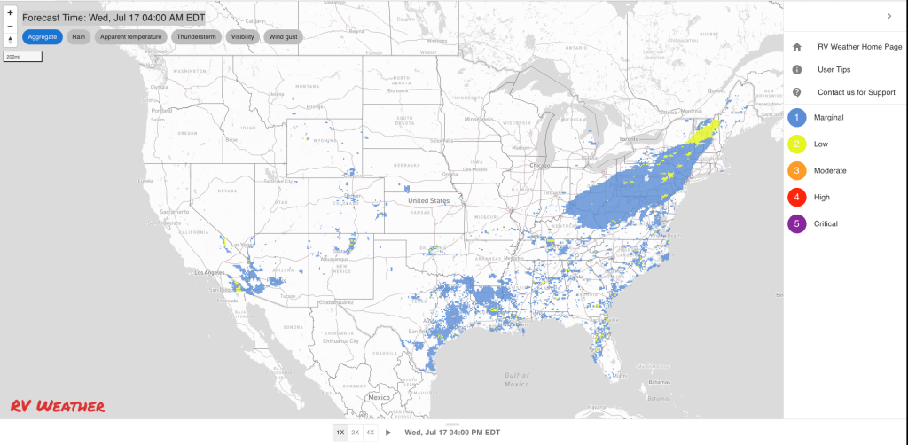
— Southern VT and NH; central and western MA; CT; NY Hudson Valley south of Albany; NJ; eastern PA; DE; DC; central and eastern MD; northern and eastern VA: Strong to severe thunderstorms possible today. Wind gusts are the primary hazard. I-64, I-66, I-70, I-76, I-78, I-80, I-81, I-83, I-84, I-86, I-87, I-88, I-89, I-90, I-91, I-93, I-95, I-99, NY Thruway, Mass, PA, NJ Turnpikes, Garden State Parkway potentially impacted.
— Southeast ME; much of eastern and southern NH; central and western MA; RI; CT; NY lower Hudson Valley; southeast and south-central PA; NJ; most of MD; DC; DE; northern, central and eastern VA; central and eastern NC; northeast SC: Excessive Heat Warnings (PA, NJ, DE) and Advisories today. Heat Index values will range from the upper 90’s in New England to 107 deg F in the Southeast.
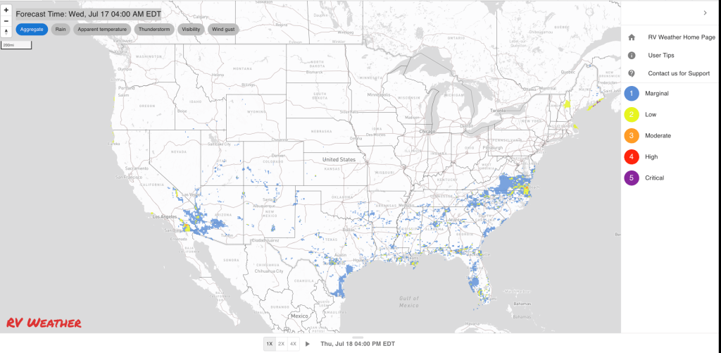
— South-central and southeast VA; central and eastern NC; northeast SC: Isolated strong to severe thunderstorms possible Thursday. Wind gusts are the primary hazard. I-20, I-40, I-64, I-74, I-85, I-95 potentially impacted.
Graphics for Today


Current Severe Thunderstorm and Tornado Watches from the National Weather Service Storm Prediction Center


Graphics for Tomorrow


Three-day Summaries


Access to real-time road information:
Phone numbers and websites for road conditions in all 50 states. Courtesy of the Cheyenne WY Weather Forecast Office
Some useful links:
Thank you for using RVWeather.