
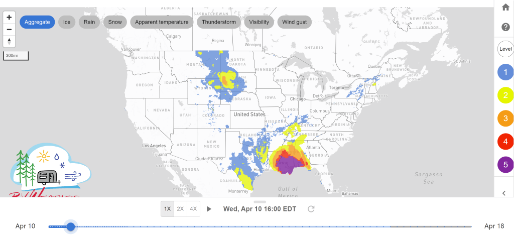
- Severe weather is expected for the central Gulf Coast states today. Widespread severe thunderstorms with a potential for several tornadoes, damaging wind and some hail are expected.
- Excessive rainfall may lead to possible flooding for the southeast US.
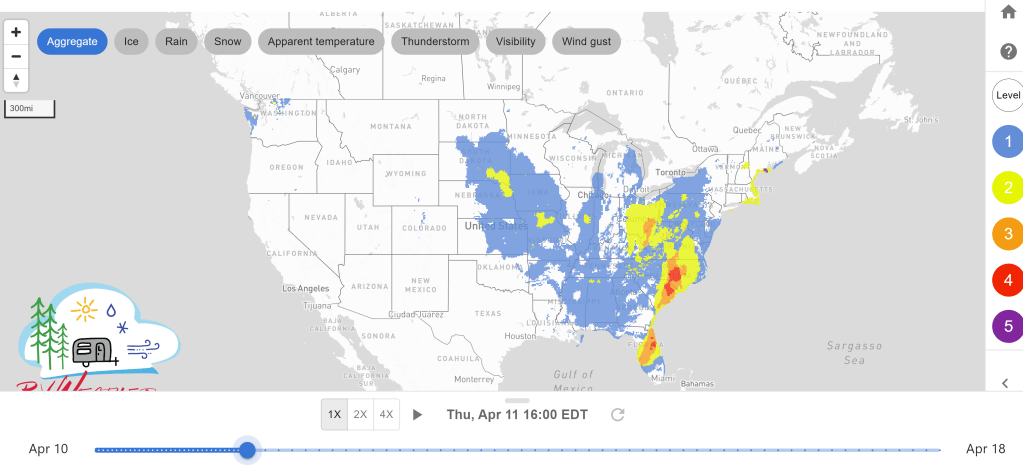
- Rain and thunderstorms with some being severe are expected for the eastern US on Thursday.
Delivered to your in-box each morning.
From the RV Weather Winter Office in State College PA:
These are the most significant weather impacts to RV travel over the next two to three days. I do not list every area of rain, showers, or breezy winds. It would be exhausting (for both of us!). Please check out the animations and graphics (included) or WILMA (subscription required) for a good depiction of the weather along your route.
Weather Impacts Pacific Time Zone:
— No significant weather to RV travel today or Thursday.
Weather Impacts Mountain Time Zone:
— Eastern MT; northeast WY: Windy conditions today. Wind gusts 30-35 mph expected. I-25, I-90, I-94, US-2 impacted.
— Southwest UT: Flash Flood Watch until further notice. Flash flooding may be caused by a potential dam failure at the Panguitch lake dam. I-15, US-89 impacted.
Weather Impacts Central Time Zone:
— Southwest ND; western SD: Wind Advisory until this evening. Winds 25-35 mph with gusts up to 50 mph. I-90, I-94, US-12, US-14, US-83, US-85 impacted.
— South TX: Wind Advisory until this evening. Winds 20-25 mph with gusts up to 45 mph. I-10, I-35, I-37, US-59, US-90 impacted.
— Eastern TX; northern LA; southern AR; portion of southeast OK; MS; central and southern AL: Flood Watch until Thursday morning. Multiple rounds of showers and thunderstorms may result in excessive runoff flooding rivers, creeks, streams, and other low-lying and flood prone areas. 4-6 inches of rainfall during this timeframe is possible. I-20, I-30, I-49, I-55, I-65, I-85 potentially impacted.
— Portion of southeast TX; south LA; south MS; south AL; panhandle of FL: Wind Advisory until this evening. Winds 20-30 mph with gusts up to 45 mph. I-10, I-12, I-49, I-55, I-59, I-65, US-43, US-45, US-90, US-98 impacted.
— Eastern TX, LA; southeast AR; MS; AL; FL panhandle: Widespread severe thunderstorms are expected across parts of the central Gulf Coast States today. There is a potential for several tornadoes with some possibly becoming EF2+. Widespread damaging wind and some hail is also expected. The largest threat is for portions of eastern LA, southern MS, and southwest AL. I-10, I-12, I-20, I-22, I-24, I-30, I-49, I-55, I-59, I-65, I-85 potentially impacted.
— Eastern ND; eastern SD; eastern NE; eastern KS; IA; MO; AR; LA; MS; AL; IL; western KY; western TN: Windy conditions on Thursday. Winds gusts up to 30-35 mph. Many roadways impacted.
Weather Impacts Eastern Time Zone:
— Northern IN; northwest OH: Flood Watch from this evening until Friday morning. Excessive rainfall may cause flooding. 1.5-2.25 inches of rain is possible. Excessive runoff may result in flooding rivers, creeks, streams, and other low-lying and flood prone areas. I-69, I-75, I-80, US-24, US-30, US-31 potentially impacted.
— Border of TN and NC in the Blount Smoky Mountains: High Wind Warning from this evening until Thursday afternoon. Winds 40-50 mph with gusts up to 75 mph. I-26, I-40 impacted.
— Panhandle of FL: Wind Advisory until Wednesday night. Winds 15-30 mph with gusts up to 45 mph. I-10 impacted.
— Southwest GA; FL panhandle: Widespread severe thunderstorms are expected across parts of the central Gulf Coast States today. There is a potential for several tornadoes with some possibly becoming EF2+. Widespread damaging wind and some hail is also expected. Though the largest threat is in LA, MS, and AL. I-10, US-19, US-84 potentially impacted.
— Western PA; much of OH; western WV; northeast KY: Severe thunderstorms are expected Thursday afternoon. Isolated hail, damaging winds, and even a few tornadoes are possible. I-64, I-70, I-71, I-75, I-76, I-77, I-79, I-80. I-90, OH turnpike, PA turnpike potentially impacted.
— Southern SC; eastern GA; northern FL: Severe thunderstorms are possible on Thursday. Scattered damaging winds and a few tornadoes are possible. I-4, I-10, I-16, I-75, I-95 potentially impacted.
— NY; NJ; PA; eastern OH; MD; DE; WV; eastern KY; eastern TN; VA; NC; SC; GA; FL: Windy conditions on Thursday. Wind gusts 30-35 mph with some areas reaching 40 mph. Many roadways impacted.


Current Severe Thunderstorm and Tornado Watches from the National Weather Service Storm Prediction Center

Two-day tropical weather outlook from the National Hurricane Center

Tornado safety information for RVers (what to do!):
Access to real-time road information:
Phone numbers and websites for road conditions in all 50 states. Courtesy of the Cheyenne WY Weather Forecast Office
Some useful links:
Thank you for using RVWeather.