
- Severe weather continues in the southern plains today. Damaging wind, large hail, and several tornadoes are possible. Excessive rainfall may cause flooding.
- Snow and rain showers expected across portions of the northwest US today.
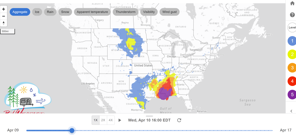
- Severe weather shifts more east on Wednesday bringing a potential for tornadoes and widespread damaging wind with the largest threat expected in the central Gulf Coast states.
Delivered to your in-box each morning.
From the RV Weather Winter Office in State College PA:
These are the most significant weather impacts to RV travel over the next two to three days. I do not list every area of rain, showers, or breezy winds. It would be exhausting (for both of us!). Please check out the animations and graphics (included) or WILMA (subscription required) for a good depiction of the weather along your route.
Weather Impacts Pacific Time Zone:
— Western WA in the Cascades: Winter Weather Advisory until tonight. Snow above 3500 ft with additional snow of 1 to 2 inches above 4000 ft and up to 6 inches above 5000 ft. I-5, I-90 impacted.
— Central WA in Kittitas Valley: Wind Advisory until this evening. Wind 20-30 mph with gusts up to 45 mph. I-90 impacted.
— Southern CA in Santa Clarita Valley and Malibu Coast: Wind Advisory through this afternoon. Winds 20-30 mph with gusts to 45 mph. I-5, US-101 impacted.
Weather Impacts Mountain Time Zone:
— Northwest MT: High Wind Warning until this evening. Winds 35-45 mph with gusts up to 65 mph. Isolated wind gusts of 80 mph are possible along the immediate eastern slopes of the Rocky Mountain Front. I-15, US-2 impacted.
— Eastern MT; northeast WY: Windy conditions on Wednesday. Wind gusts 30-35 mph expected. I-25, I-90, I-94, US-2 impacted.
— Central NM: Wind Advisory until this afternoon. Winds 25-35 mph with gusts up to 55 mph expected. I-25, I-40, US-54 impacted.
— South NM in the South Central Mountains: Winter Weather Advisory until this evening. Snow with accumulation up to 2 to 5 inches with 10 to 20 inches above 7500 ft. Wind gusts up to 45 mph. US-70, US-82 impacted.
Weather Impacts Central Time Zone:
— Southwest TX: Red Flag Warning from noon today through tonight. Gusts of 45 mph with low humidity. Avoid use of open flames or any activities that may generate sparks. Potential for wildfires. I-10, US-90 impacted.
— Eastern TX; northern LA; southern AR; portion of southeast OK; northern MS central AL: Flood Watch until Thursday morning. Multiple rounds of showers and thunderstorms may result in excessive runoff flooding rivers, creeks, streams, and other low-lying and flood prone areas. 4-6 inches of rainfall during this timeframe is possible. I-20, I-30, I-49, I-55, I-65 potentially impacted.
— Central and eastern TX; much of LA; southern AR: Severe thunderstorms expected today. Several tornadoes, a couple of which could be strong, along with large hail and damaging winds are likely. Greatest threat will be across eastern and central TX and western LA. I-10, I-20, I-30, I-35, I-45, I-49 potentially impacted.
— Western ND; western SD; northern NE: Windy conditions throughout Wednesday. Wind gusts up to 35-40 mph. I-90, I-94, US-12, US-14, US-20, US-52, US-83, US-85 impacted.
— Southeast LA; south MS: Wind Advisory until Wednesday evening. Winds 20-30 mph with gusts up to 45 mph. I-10, I-12, I-55, I-59, US-90, US-98 impacted.
— Eastern TX; LA; southern AR; south-central TN; MS; AL; FL panhandle: Numerous to widespread severe thunderstorms are probable beginning Wednesday morning across parts of the central Gulf Coast States. These will include potential for both many tornadoes, some of which should be strong (EF2-EF3 caliber), and widespread damaging wind swaths with embedded significant severe gusts. I-10, I-12, I-20, I-22, I-24, I-30, I-40, I-49, I-55, I-59, I-65, I-85 potentially impacted.
Weather Impacts Eastern Time Zone:
— Northern OH; northwest PA; west NY: Scattered showers and thunderstorms this afternoon. Isolated severe hail and strong wind gusts are possible. I-69, I-71, I-76, I-77, I-75, I-79, I-80, I-86, I-90, I-94, I-96, OH turnpike potentially impacted.
— Southwest GA; FL panhandle: Severe thunderstorms are probable Wednesday. Potential for both many tornadoes, some of which should be strong (EF2-EF3 caliber), and widespread damaging wind swaths with embedded significant severe gusts. Though the largest threat is in the central Gulf Coast States. I-10, I-16, I-20, I-24, I-40, I-75, I-81, I-85 potentially impacted.
— Much of OH; western WV; northern and eastern KY: Scattered severe thunderstorms possible on Thursday. I-64, I-70, I-71, I-75, I-76, I-80 potentially impacted.
— Central and southeast NC; SC; southern and eastern GA; northern FL: Scattered severe thunderstorms possible on Thursday. I-10, I-16, I-20, I-26, I-75, I-77, I-85, I-95 potentially impacted.


Current Severe Thunderstorm and Tornado Watches from the National Weather Service Storm Prediction Center


Two-day tropical weather outlook from the National Hurricane Center


Tornado safety information for RVers (what to do!):
Access to real-time road information:
Phone numbers and websites for road conditions in all 50 states. Courtesy of the Cheyenne WY Weather Forecast Office
Some useful links:
Thank you for using RVWeather.