
- Flooding rains today along the Texas coast and also across much of the Carolinas.
- Heat, winds and low humidities combine to create high wildfire danger conditions from the Pacific Northwest, across the Inter-Mountain West and northern Rockies, and into the Northern Plains.
- Dangerous heat continues for much of interior central and southern California west of the Sierra Nevadas.
From the RV Weather Field Office in State College PA:
These are the most significant weather impacts to RV travel over the next two to three days. I do not list every area of rain, showers, or breezy winds. It would be exhausting (for both of us!).
Weather Impacts Pacific Time Zone:
— Portions of east-central and southeast WA: Red Flag (fire danger) Warnings this afternoon and evening. Wind gusts to 30 mph. I-90, US-12, US-195, US-395 impacted.
— Portions of south-central OR; northeast CA; northwest NV: Red Flag (fire danger) Warnings this afternoon into tonight. Wind gusts to 40 mph. US-95, US-395 impacted.
— Much of central CA west of the Sierra Nevada: Excessive Heat Warnings and Advisories through this evening. High temperatures 101-111 deg F.
— Southern CA foothills and mountains away from the immediate coast: Heat Advisories today. High temperatures mid 90’s to 106 deg F.
— Interior southern CA; and southeast CA interior deserts and east of the Sierra Nevada, including the Mojave Desert and Death Valley National Park; southern NV; adjacent northwest AZ: Excessive Heat Warnings through Friday. High temperatures 107 – 118 deg F with temperatures reaching the mid-120’s deg F in Death Valley NP. I-8, I-10, I-15, I-40, US-395, CA-14, CA-58 impacted.
Weather Impacts Mountain Time Zone:
— Much of southern and eastern ID; most of MT; much of central and eastern WY: Red Flag (fire danger) Warnings this afternoon into early tonight. Wind gusts outside of thunderstorms up to 30-45 mph. Strongest winds along the Rocky Mountain Front. Outflow wind gusts from thunderstorms may reach 50 mph. I-15, I-25, I-80, I-84, I-86, I-90, US-2, US-12, US-14, US-16, US-18, US-20, US-26, US-30, US-85, US-87, US-89, US-93, US-95, US-191, US-212, US-287 impacted.
— Much of central and north-central MT north of I-90: Locally strong thunderstorms today may produce damaging wind gusts. I-90, US-2, US-12, US-87 potentially impacted.
— Much of central and eastern MT; much of eastern WY: Excessive Heat Warnings and Advisories through this evening. High temperatures 100-110 deg F. I-25, I-90, I-94, US-2 US-12 impacted.
— Portions of west-central and northwest AZ: Excessive Heat Warnings through this evening. High temperatures 106-117 deg F. I-40, US-93 impacted.
— South-central and southeast AZ: Locally strong thunderstorms today may produce damaging wind gusts. I-8, I-10, I-17, I-19 potentially impacted.
Weather Impacts Central Time Zone:
— Southwest ND; western SD; northwest NE: Red Flag (fire danger) Warnings today through late this evening. Wind gusts to 35 mph. I-80, I-90, I-94, US-12, US-14, US-20, US-26, US-85, US-212, US-385 impacted.
— Western and central ND and SD; northwest NE: Heat Advisories today. High temperatures up to 108 deg F.
— Much of ND; central and western SD: Strong winds this afternoon into tonight. Wind gusts to 40 mph. I-29, I-90, I-94 impacted.
— Western SD: Isolated severe thunderstorms possible Friday. Wind gusts are the primary hazard. I-90 potentially impacted.
— Eastern SD; northwest MN: Isolated severe thunderstorms possible Friday. Wind gusts and hail are the primary hazards. I-29, I-94 potentially impacted.
— Eastern SD; northeast, central and south-central SD; central and southwest NE; western KS: Strong winds midday Friday into Friday afternoon. Wind gusts 30-35 mph. I-29, I-70, I-80, I-90, I-94 potentially impacted.
— Central and eastern ND; northwest MN; much of SD; western NE: Strong to severe thunderstorms possible on Saturday. I-29, I-80, I-90, I-94 potentially impacted.
— Coastal and southeast TX north of Corpus Christi; adjacent southwest LA: Flood Watches continue through this evening. An additional 2-4 inches of rainfall is possible. I-10, I-45 impacted.
Weather Impacts Eastern Time Zone:
— Northern ME: Strong, potentially severe, thunderstorms are possible this afternoon.
— Southeast Tidewater VA; eastern NC: Strong to marginally severe thunderstorms possible today. Wind gusts are the primary hazard. I-40, I-64, I-85, I-95, US-13, US-17 US-64 potentially impacted.
— Central and eastern NC and SC: Flood Watches continue through this evening. An additional 2-4 inches of rainfall in some areas is possible on top of already saturated ground. I-20, I-26, I-40, I-73, I-77, I-85, I-95, US-13, US-17, US-64 potentially impacted.
— Southeast FL: Heat Advisory today. Heat index 102-105 deg F.
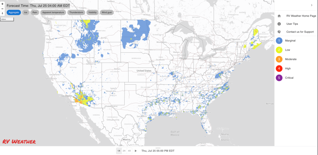
Graphics for Today


Current Severe Thunderstorm and Tornado Watches from the National Weather Service Storm Prediction Center


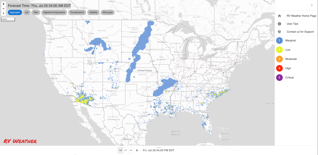
Graphics for Tomorrow


Three-day Summaries


Access to real-time road information:
Phone numbers and websites for road conditions in all 50 states. Courtesy of the Cheyenne WY Weather Forecast Office
Some useful links:
Thank you for using RVWeather.