
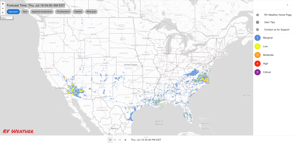
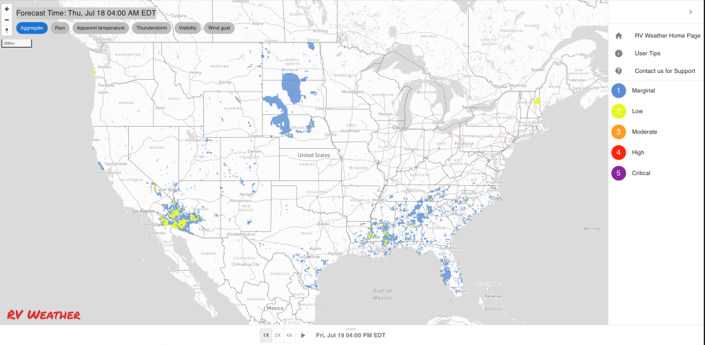
- Isolated strong to severe thunderstorms are possible this afternoon across the central and southern High Plains as well Virginia into the eastern Carolinas.
- Heat returns to the West; hottest days will be Sunday and Monday.
- A wet weekend with persistent heavy rain showers coming up for the Deep South and Southeast.
From the RV Weather Field Office in State College PA:
These are the most significant weather impacts to RV travel over the next two to three days. I do not list every area of rain, showers, or breezy winds. It would be exhausting (for both of us!).
Weather Impacts Pacific Time Zone:
— Much of central and eastern WA; northern ID: Heat Advisories through Sunday. High temperatures 95 – 111 deg F.
— East-central and southeast OR: Excessive Heat Watch Saturday through next Tuesday. High temperatures could reach 105 deg F. Hottest days will be Sunday and Monday. I-84, US-20, US-95 impacted.
— Central CA west of I-5, except on the immediate coast: Heat Advisories today and Friday. High temperatures in the upper 90’s and lower 100’s deg F.
— A portion of central CA: Excessive Heat Watch next Monday through Wednesday. High temperatures as high as 110 deg F.
— Southern CA foothills and mountains away from the immediate coast: Heat Advisories Friday through Sunday. High temperatures up to 106 deg F. Hottest days will be Friday and Saturday.
— Interior southern CA; and southeast CA interior deserts and east of the Sierra Nevada, including the Mojave Desert and Death Valley National Park; southern NV: Excessive Heat Warnings Saturday and Sunday. High temperatures 107 – 118 deg F with temperatures well above 120 deg F in Death Valley NP. I-8, I-10, I-15, I-40, US-395, CA-14, CA-58 impacted.
Weather Impacts Mountain Time Zone:
— North-central MT: Isolated strong to severe thunderstorms possible this afternoon. Wind gusts are the primary hazard. I-15 potentially impacted.
— Southwest and south-central ID: Red Flag (fire danger) Warning this afternoon and evening for isolated dry thunderstorms. Wind gusts may approach 55 mph in thunderstorm outflow regions. I-84, I-86, US-93, US-95 potentially impacted.
— Southwest ID along the I-84 corridor: Excessive Heat Warnings and Watches through next Tuesday. High temperatures 105-110 deg F. Hottest days Sunday and Monday. I-84, US-26, US-93, US-95 impacted.
— Southeast WY; eastern CO; northeast and east-central NM : Isolated strong to severe thunderstorms are possible this afternoon. Wind gusts and hail will be the primary hazards. I-25, I-40, I-70, I-76, I-80 potentially impacted.
— Far-eastern WY; northeast and east-central CO: Isolated strong to severe thunderstorms are possible Friday afternoon. Wind gusts and hail will be the primary hazards. I-70, I-76, I-80, I-90 potentially impacted.
— Portions of southwest UT Zion National Park: Excessive Heat Watch Saturday and Sunday. High temperatures may reach 111 deg F. I-15 impacted.
— Much of western and south-central AZ: Excessive Heat Warnings Friday and Saturday. High temperatures 110-117 deg F. I-8, I-10, I-17, I-40 impacted.
— Much of central, northeast and east-central NM: Flood Watches this afternoon through late tonight. Flash flooding may be caused by an increase in the number and intensity of showers and thunderstorms. Rainfall rates may exceed 2 inches per hour. I-25, I-40, US-54, US-60, US-64, US-70, US-84, US-285, US-380 potentially impacted.
Weather Impacts Central Time Zone:
— Western NE; western KS; western OK Panhandle: Isolated strong to severe thunderstorms are possible this afternoon. Wind gusts and hail will be the primary hazards. I-70, I-80, I-90, US-20, US-26, US-64, US-385 potentially impacted.
— Western, central and southern SD; much of NE; north-central and northwest KS: Isolated strong to severe thunderstorms are possible Friday. Wind gusts and hail will be the primary hazards. I-70, I-80, I-90 potentially impacted.
— Portions of southwest and south-central MS: Heat Advisory today. Heat index values of 105 deg F.
Weather Impacts Eastern Time Zone:
— Tidewater VA; east-central and northeast NC: Isolated to scattered severe thunderstorms expected today. Wind gusts and hail are the primary hazards. I-40, I-64, I-85, I-95, US-13, US-64 potentially impacted.
— Tidewater VA; northeast NC: Flood Watch through this evening. Rainfall rates of 2-4 inches per hour are likely, associated with a slow-moving cold front. I-64, US-13, US-17, US-64, US-70 impacted.
— Southern and southeast VA; north-central and northeast NC: Isolated strong to severe thunderstorms possible on Saturday. I-40, I-64, I-74, I-77, I-85, I-95 potentially impacted.
— Southeast FL, including Miami: Heat Advisory today. Heat index value up to 107 deg F.
Graphics for Today


Current Severe Thunderstorm and Tornado Watches from the National Weather Service Storm Prediction Center


Graphics for Tomorrow


Three-day Summaries


Access to real-time road information:
Phone numbers and websites for road conditions in all 50 states. Courtesy of the Cheyenne WY Weather Forecast Office
Some useful links:
Thank you for using RVWeather.