
- Widespread, near record-breaking heat persists across the West for much of this coming week.
- Monsoon conditions, including strong thunderstorms, across southern Arizona and the Southern Rockies today.
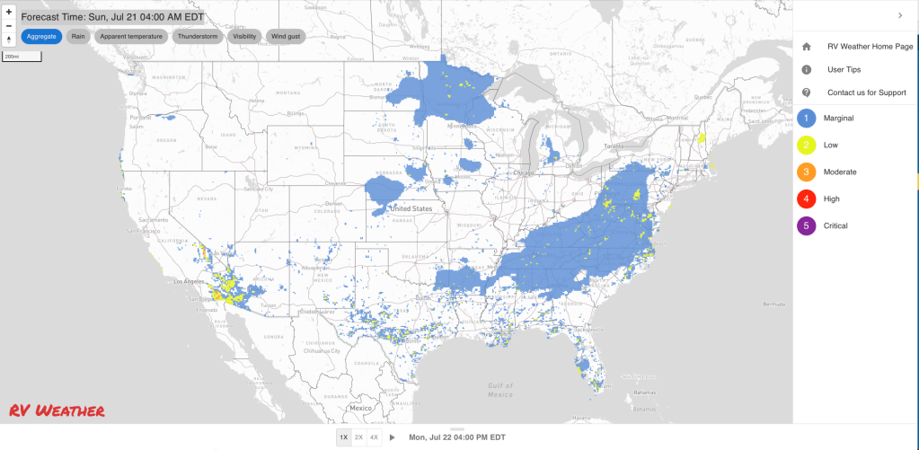
- Numerous showers and thunderstorms from Arizona to Georgia today, then spreading northwards to Pennsylvania on Monday.
From the RV Weather Field Office in State College PA:
These are the most significant weather impacts to RV travel over the next two to three days. I do not list every area of rain, showers, or breezy winds. It would be exhausting (for both of us!).
Weather Impacts Pacific Time Zone:
— Portions of western and north-central WA; much of OR: Red Flag (fire danger) Warnings today. Hot temperatures, very low humidities and unstable conditions may produce extreme fire behavior. I-5, I-84, I-90, US-2, US-12, US-20, US-26, US-95, US-97, US-101, US-395 potentially impacted.
— Much of central and eastern WA and OR; north-central and northeast CA; northern NV; northern ID: A combination of Excessive Heat Warnings and Advisories through Monday. Hottest days Sunday and Monday. Advisories continue through Wednesday in parts of OR and NV. High temperatures 95 – 110 deg F.
— Portions of northern and central CA including the Sacramento and northern San Joaquin Valleys and the greater Bay Area: Heat Advisories Monday through Wednesday. High temperatures 100-110 deg F.
— A portion of interior central CA: Excessive Heat Warning Monday through Wednesday. High temperatures as high as 111 deg F.
— Southern CA foothills and mountains away from the immediate coast: Heat Advisories through Wednesday. High temperatures mid 90’s to 105 deg F.
— Interior southern CA; and southeast CA interior deserts and east of the Sierra Nevada, including the Mojave Desert and Death Valley National Park; southern NV; adjacent northwest AZ: Excessive Heat Warnings today. High temperatures 107 – 118 deg F with temperatures reaching the mid-120’s deg F in Death Valley NP. I-8, I-10, I-15, I-40, US-395, CA-14, CA-58 impacted.
Weather Impacts Mountain Time Zone:
— Northwest MT; northern and central ID: Excessive Heat Warnings and Advisories through Tuesday. High temperatures generally 95-105 deg F.
— Southwest and south-central ID along the I-84 corridor: Excessive Heat Warnings and Advisories through Wednesday. High temperatures 104-108 deg F. I-84, US-26, US-93, US-95 impacted.
— North-central and parts of northwest AZ: Excessive Heat Warnings today. High temperatures 106-116 deg F. I-40, US-93 impacted.
— Much of central and southern AZ: Isolated, marginally severe thunderstorms are possible this afternoon into early evening. Wind and some hail are the primary hazards. I-8, I-10, I-17, I-40, US-60, US-70 potentially impacted.
— South-central CO; Much of southwest, central and eastern NM north of I-10: Flood Watches this afternoon through late tonight. Flash flooding may be caused by an increase in the number and intensity of showers and thunderstorms. Rainfall rates may exceed 2 inches per hour. I-25, I-40, US-24, US-50, US-54, US-60, US-64, US-70, US-84, US-285, US-380 potentially impacted.
— South-central CO; northeast and east-central NM: Isolated, marginally severe thunderstorms are possible this afternoon into early evening. Wind and some hail are the primary hazards. I-25, I-40, US-50, US-64 potentially impacted.
Weather Impacts Central Time Zone:
— Eastern ND; northeast SD; MN; northwest WI: Strong thunderstorms possible Monday evening. I-29, I-35, I-90, I-94 potentially impacted.
— Much of south-central and eastern NE; southeast SD; western IA; southwest MN: Dense Fog Advisories this morning. I-29, I-80, I-90 impacted.
Weather Impacts Eastern Time Zone:
— Central and southern IN; KY; TN; southeast OH; central and southern PA; WV; central and western MD; much of VA; central and western NC: Widely scattered strong, possibly severe thunderstorms possible Monday afternoon and evening. I-24, I-40, I-64, I-65, I-66, I-68, I-69, I-70, I-76, I-77, I-78, I-79, I-80, I-81, I-83, I-85, I-95, I-99, PA Turnpike potentially impacted.
— Southern FL: Heat Advisory today and Sunday. Heat index values may reach 105-110 deg F.
Graphics for Today


Current Severe Thunderstorm and Tornado Watches from the National Weather Service Storm Prediction Center


Graphics for Tomorrow


Three-day Summaries


Access to real-time road information:
Phone numbers and websites for road conditions in all 50 states. Courtesy of the Cheyenne WY Weather Forecast Office
Some useful links:
Thank you for using RVWeather.