
- Beryl is in the southwest Gulf of Mexico, heading for Texas. Landfall as a hurricane is likely along the Texas Coast on Monday. Anyone living in or traveling this weekend to the Texas coast, especially Corpus Christi and north, should prepare for deteriorating conditions late Sunday and hurricane conditions Monday. Storm surge along much of the coast could reach 3-5 feet.
- Beryl will likely bring flooding rains to much of eastern TX early next week.
- Heat Wave and high fire danger conditions continue across the West this weekend and all of next week; high heat index values today for parts of the Northeast, and much of the Mid-Atlantic Region and Southeast.
From the RV Weather Field Office in State College PA:
These are the most significant weather impacts to RV travel over the next two to three days. I do not list every area of rain, showers, or breezy winds. It would be exhausting (for both of us!).
Weather Impacts Pacific Time Zone:
— WA; northern ID; OR; CA; much of NV: A combination of Red Flag (fire danger) Warnings and Excessive Heat Warnings, Watches and Advisories continue well into next week. High temperatures will range from the 90’s across WA, to lower 100’s for much of OR, to 100-115 deg for large portions of CA away from the immediate coat. Temperatures in Death Valley will range from 125-130 deg F. Many places will see gusty afternoon winds of 20-30 mph and very low humidities creating high potential for the rapid spread of any wildfires that start.
Weather Impacts Mountain Time Zone:
— Western, central and northern ID; northwest MT: Excessive Heat Watches Monday continuing through next Friday. High temperatures will range from the 90’s in MT to the lower 100’s in southwest ID.
— South-central ID; southwest, central and northeast UT; northwest CO; central and portions of south-central WY: Red Flag (fire danger) Warnings through Sunday. Wind gusts 30-35 mph. I-15, I-25, I-70, I-80, US-20, US-26, US-40, US-89, US-191 impacted.
— South-central UT Glen Canyon Recreation Area, Lake Powell, Zion National Park: Excessive Heat Warnings Sunday through Wednesday. Temperatures between 110-115 deg F.
— South-central and western AZ including the Phoenix metro area: Excessive Heat Warnings (northwest AZ) and Watches through Tuesday. Afternoon temperatures 110-118 deg F. Temperatures may reach 120 deg F in the Colorado Valley.
— AZ Grand Canyon below 4000 feet: Excessive Heat Warning through Tuesday. Temperatures reaching 114 deg F.
— South-central NM: Flood Watch this afternoon and evening. Showers and thunderstorms may produce flash flooding, especially over burn scars. US-70, US-82, US-380 potentially impacted.
— South-central NM and far-west TX: Heat Advisories Sunday. High temperatures 103-108 deg F.
Weather Impacts Central Time Zone:
— Coastal TX, from south of Galveston Island to the Mexican Border: Hurricane Watches and Storm Surge Watches in effect from Sunday afternoon through Monday. Tropical Storm Beryl is 500 miles southeast of Corpus Christi TX, with maximum winds of 60 mph. The storm will likely intensify Sunday and Monday, and make landfall as a hurricane sometime Monday, most likely near or north of Corpus Christi. Know where and how to get reliable emergency management information for your campground or location. Be prepared for hurricane force winds and a storm surge of 3-5 feet. Have a plan to evacuate if you are directed to do so. RVs are not hurricane shelters. Please follow local Emergency Management guidance and recommendations. I-2, I-69, I-37, I-45, US-77, US-281 will be impacted.
— Eastern TX: Heavy, flooding rains Monday and Tuesday as Beryl move through the state. While hurricane conditions will impact the immediate coast, Beryl’s primary impact on Texas will be excessive rainfall and floods. Up to 8-12 inches of rain could fall from east of Waco southward to the coast, with much of eastern Texas seeing 4 or more inches of rainfall.
— Central and northern TX Coast: Risk of tornadoes increases Sunday and Monday as Beryl approaches the coast.
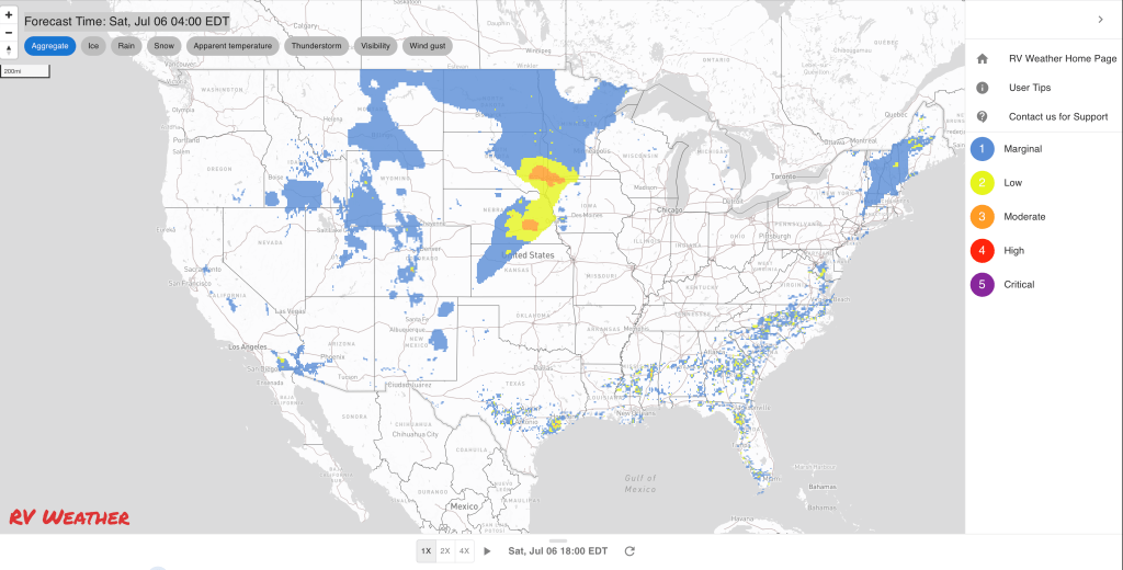
— South-central and northeast NE; western KS; OK Panhandle: Scattered severe thunderstorms expected today. These storms may contain large hail over 2 inches in diameter. I-29, I-70, I-80 potentially impacted.
— Central OK: Flood Watch Sunday afternoon through Monday morning. Heavy showers and thunderstorms may bring 1-3 inches of rainfall across this region. I-35, I-40, I-44 potentially impacted.
— Central OK; eastern TX Panhandle: Severe thunderstorms expected on Sunday. I-35, I-40, I-44 potentially impacted.
— Central and south AL; FL Panhandle: Heat Advisories today. Expect heat index values around 109 deg F.
Weather Impacts Eastern Time Zone:
— NY Hudson Valley from Albany south; NJ; southeast PA; central and eastern MD; DE; DC; northern, central and eastern VA; central and eastern NC; most of SC; central and southern GA; northern FL: Excessive Heat Warnings (NJ southward to NC) and Advisories today. Heat index values will range from the upper 90’s in NY to 107-112 deg F across much of the Mid-Atlantic and Southeast.
Graphics for Today


Current Severe Thunderstorm and Tornado Watches from the National Weather Service Storm Prediction Center


Graphics for Tomorrow


Three-day Summaries


Access to real-time road information:
Phone numbers and websites for road conditions in all 50 states. Courtesy of the Cheyenne WY Weather Forecast Office
Some useful links:
Thank you for using RVWeather.