
** Heads Up ** RVers traveling in the Western or Central US through early next week can expect difficult and hazardous travel conditions. Widespread wind gusts greater than 60 mph in the West. Winter-like snows across the Major Passes on I-5, I-80 and throughout the Northern Rockies. Flooding rains over eastern Texas. High winds spread onto the Plains on Monday along with a return of significant and dangerous severe thunderstorms across the Central Plains.
- Be prepared for winter conditions and potentially closed roads if you are taking I-80 across the Wasatch, Nevada or Donner Pass this weekend. Expect winter conditions starting Sunday if you are visiting Yellowstone or Grand Teton National Parks.
- High winds dominate the California deserts, Great Basin, Southwest, and central and southern Rockies this weekend.
- Severe thunderstorms likely this evening across western Texas.
- Heavy, flooding rains with significant flash flood potential, continue today across eastern Texas.
Have the daily forecast delivered to your in-box each morning.
From the RV Weather Field Office in State College, Pennsylvania:
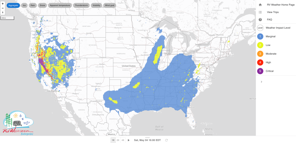
These are the most significant weather impacts to RV travel over the next two to three days. I do not list every area of rain, showers, or breezy winds. It would be exhausting (for both of us!). Please check out the animations and graphics (included) or WILMA (subscription required) for a good depiction of the weather along your route.
Weather Impacts Pacific Time Zone:
— Western WA; western OR; northern and central CA: Rain, sometimes heavy, today. Unsettled conditions across the Pacific Northwest continue through Monday. 1-3 inches of rain expected along the WA, OR and northern CA coasts and western-facing higher terrain. I-5, I-80, I-84, I-90, US-101 impacted.
— South-central WA; north-central and northeast OR: Wind Advisories tonight through Sunday night. Gusts to 50 mph. I-84, US-26, US-97,US-395 impacted.
— OR Cascades: Winter Weather Advisories above 3500 feet through midday Sunday. 4-10 inches snow expected, with snow accumulations reaching 16 inches above 5000 feet. Wind gusts to 35-40 mph. US-20, US-26, OR-58, OR-140 impacted.
— Central OR: Winter Weather Advisory late this afternoon into Sunday night above 4000 feet. 3-6 inches snow expected. US-20, US-26, US-97, US-395 impacted.
— Much of south-central and southwest OR: Wind Advisories today. Gusts to 45 mph. US-20, US-395 impacted.
— CA/OR Siskiyou Pass on I-5: Winter Weather Advisory today and early tonight . Snow above 4000 feet. 3-7 inches expected. I-5 impacted.
— Northwest CA: Winter Weather Advisories above 4000 feet through midday today. 2-5 inches of snow and gusts to 40 mph. US-101, US-199, CA-299 impacted.
— Northern CA central and northern Sacramento Valley: Wind Advisory this morning. Gusts to 50 mph. I-5, CA-36, CA-99 impacted.
— Northeast CA: Winter Weather Advisories above 5000 feet midday today through early Sunday morning. 3-7 inches snow and wind gusts to 55 mph. US-395, CA-36, CA-44 impacted.
— CA Sierra Nevada: Winter Storm Warnings above 5000 feet late this morning through Sunday morning. 6-15 inches of snow above 5000 feet. 2-6 inches snow above 4000 feet. Snow levels lower to 3000 feet by early Sunday morning. Wind gusts 30-50 mph. Snowfall rates up to 2 inches per hour much of today and this evening. I-80, US-50 impacted.
— Northwest NV: Wind Advisory today. Gusts to 50 mph. I-80 impacted.
— Northeast and east-central NV: Winter Weather Advisories late this evening through midday Sunday above 6500 feet. 1-7 inches of snow and wind gusts to 70 mph. I-80, US-93 impacted.
— Much of central and southwest NV; southeast CA northern Mojave Desert and Mojave Desert Slopes: High Wind Warnings today into early tonight. Wind gusts 60-65 mph except gusts to 80 mph in the Humbolt and Ruby Mountain (eastern NV) Ranges. Us-6, US-50, US-93, US-95, US-395, CA-14, CA-58 impacted.
— Southern and southeast NV: Wind Advisories late this morning through early Sunday morning. Gusts to 55 mph. I-15, US-93, US-95 impacted.
— Southern CA Mountains from the San Gabriels north of Los Angeles to the San Diego County Mountains: Wind Advisories this afternoon through Sunday. Gusts 50-60 mph. Strongest winds in the San Diego County Mountains. I-8, I-10, I-15, CA-14 impacted.
— Southern CA interior deserts, Salton Sea, Imperial Valley: Wind Advisories this afternoon through Sunday. Wind gusts 45-55 mph. I-8, I-10, I-15, I-40, US-395, CA-14, CA-58, CA-78, CA-86, CA-111 impacted.
Weather Impacts Mountain Time Zone:
— Southwest ID Treasure Valley and south-central ID: Wind Advisories today. Gusts to 45 mph. I-84, I-86 impacted.
— Northwest WY including Yellowstone National Park; west-central WY Teton, Gros Ventre Mountains: Winter Storm Watches Sunday evening through late Tuesday night. Snow accumulations wil range from 5-10 inches in northern Yellowstone to 1-2 feet in the Teton and Gros Ventre Mountains. US-14, US-16, US-26, US-89, Togwotee Pass impacted.
— Western UT; northwest AZ: High Wind Warnings (west-central UT) and Advisories this afternoon through midday Sunday. Wind gusts 55-60 mph. I-15, I-80, US-50, US-93 impacted.
— Northeast and north-central UT; adjacent southeast ID: Winter Storm Warnings (UT) and Watches (ID) Sunday through midday Tuesday. 8-16 inches snow expected. I-80, US-6, US-40, US-89, US-189 impacted.
— Central and southwest WY; eastern UT and western CO; much of northern and central AZ: High Wind Watches Sunday and Monday. Widespread wind gusts to 65 mph. Major highways impacted include I-17, I-25 (north of Casper WY), I-40, I-70, I-80, US-20, US-40, US-50, US-89, US-191, US-287.
— Central and western NM: Red Flag (fire danger) Warnings Sunday. Wind gusts 45-55 mph. I-10, I-25, I-40, US-54, US-60, US-64, US-70, US-180, US-285, US-491, US-550 impacted.
— Southeast NM: Scattered severe thunderstorms expected this afternoon. Very large hail and a tornado or two is possible. US-62, US-82 potentially impacted.
Weather Impacts Central Time Zone:
— Western and central ND; western and central SD; western NE: Strong winds develop Sunday afternoon, then expand eastwards and intensify. By Monday afternoon strong winds will encompass the Plains from ND southward to TX, west of I-35. Wind gusts on Sunday will be 35-45 mph. Wind gusts on Monday will increase to 40-55 mph. By Monday, I-27, I-29, I-35, I-40, I-70, I-80, I-90, I-94 will be impacted.
— Central and eastern NE; southwest IA; most of KS; western MO; OK except the Panhandle and adjacent north-central TX; northwest AR: Numerous severe thunderstorms will likely develop Monday afternoon and evening. Very large to GIANT hail and damaging winds all possible. I-29, I-35, I-40, I-44, I-70, I-80 potentially impacted.
— Much of central and eastern OK and adjacent north-central TX; northwest AR: Flood Watches today and Sunday. Additional rainfall of 1-3 inches is possible. I-35, I-40, I-44 potentially impacted.
— Much of central and southwest TX west of I-35 and south of I-27: Scattered severe thunderstorms, with the threat for very large hail, damaging winds and perhaps a few tornadoes, are expected this afternoon and evening. I-10, I-20, I-27, I-35 potentially impacted.
— Portions of southeast TX: FLOOD WARNINGS, and Flood Watches embedded FLASH FLOOD WARNINGS continue through Sunday. An additional 1-3 inches of rain may fall on what is already very saturated ground. I-10, I-45 potentially impacted.
— Central and eastern TX; eastern OK; AR; northern and western LA; western and northern MS; western TN: Isolated strong to severe thunderstorms may occur Sunday. I-10, I-20, I-22, I-30, I-35, I-37, I-40, I-45, I-49, I-55 potentially impacted.
— Southern IL; southeast MO; western KY and TN; northeast AR; southeast AR and northeast LA; most of MS; western AL; western FL Panhandle: Dense Fog Advisories this morning. I-10, I-20, I-22, I-24, I-40, I-55, I-57, I-59, I-65 impacted.
Weather Impacts Eastern Time Zone:
— Central and eastern OH; western PA; northwest WV: Isolated strong to severe thunderstorms possible Sunday. I-70, I-71, I-76, I-77, I-79, I-80, I-90, PA and OH Turnpikes potentially impacted.
— New England; NY; PA; central and western MD; central and western VA; central and western NC; upstate SC: Rain, rain showers and embedded thunderstorms, some strong, throughout the weekend. Heaviest rain amounts will be across central and southwest VA, and central and western NC. Rainfall in these locations will be 1-2 inches.


Learn more about WILMA


Current Severe Thunderstorm and Tornado Watches from the National Weather Service Storm Prediction Center


Two-day tropical weather outlook from the National Hurricane Center


Tornado safety information for RVers (what to do!):
Access to real-time road information:
Phone numbers and websites for road conditions in all 50 states. Courtesy of the Cheyenne WY Weather Forecast Office
Some useful links:
Thank you for using RVWeather.