
- Red Flag Warnings for high wildfire danger extend from Idaho to Arizona.
- Scattered severe thunderstorms this weekend across the Northern Plains.
- Excessive heat and humidity return to the Southern Plains and Mid-South early next week and persist into August.
From the RV Weather Field Office in State College PA:
These are the most significant weather impacts to RV travel over the next two to three days. I do not list every area of rain, showers, or breezy winds. It would be exhausting (for both of us!).
Weather Impacts Pacific Time Zone:
— Central CA portions of the southern Sierra Nevada Range: Red Flag (fire danger) Warning today and early tonight. Wind gusts 30-40 mph. CA-178 impacted.
— Southern CA Mojave Desert Slopes: Wind Advisory early this morning. Wind gusts to 45 mph. Wind gusts 30-35 mph return in this area this afternoon and evening. US-395, CA-14, CA-58 impacted.
Weather Impacts Mountain Time Zone:
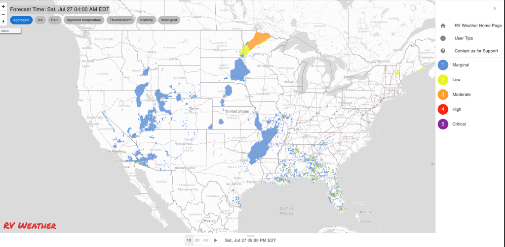
— Portions of eastern and southeast ID: Red Flag (fire danger) Warnings this afternoon and evening. Scattered thunderstorms. Wind gusts to 30 mph outside of thunderstorms. Thunderstorm outflow wind gusts may reach 40-60 mph. I-15, US-20, US-26, US-93 impacted.
— Northern UT; central, southern, and eastern WY; northwest and northeast CO: Strong to marginally severe thunderstorms this afternoon and evening. Damaging wind gusts are the primary hazard. I-15, I-25, I-70, I-76, I-80, I-84 potentially impacted.
— Portions of northwest, southwest, central and south-central WY; parts of northwest, central and south-central CO: Strong winds Sunday afternoon and evening. Gusts to 35 mph. I-70, I-80, US-14, US-16, US-20, US-26, US-40, US-50 potentially impacted.
— Northeast, west-central, southwest, south-central UT; northwest and west-central AZ: Red Flag (fire danger) Warnings today and Sunday. Wind gusts 30-35 mph each afternoon. I-15, I-40, I-70, US-6, US-40, US-50, US-89, US-93, US-191 impacted.
— North-central NM north and west of I-25; south-central NM: Flood Watches this afternoon and evening for monsoon showers and thunderstorms. Localized rainfall rates may reach 1 inch per hour resulting in flash flooding. US-64, US-70, US-380 potentially impacted.
Weather Impacts Central Time Zone:
— Central and eastern ND; northwest MN: Scattered severe thunderstorms possible this afternoon and evening. Wind gusts, hail, and a tornado or two are possible. I-29, I-94 potentially impacted.
— Much of SD: Scattered severe thunderstorms expected on Sunday. Wind gusts and hail are the primary hazards. I-90 potentially impacted.
— Southeast MN; southwest and southern WI; most of IA; northern and eastern MO; IL; far-western KY: Scattered strong to severe thunderstorms are possible on Monday.
— Eastern SD; central NE: Strong winds this afternoon and evening. Wind gusts around 30 mph. I-29, I-80, I-90 impacted.
— Coastal and southeast TX north of Corpus Christi: Flood Advisories and Watches continue through this afternoon. An additional 1-2 inches of rainfall is possible along the coast through the weekend, with lesser amounts inland. I-10, I-45 impacted.
Weather Impacts Eastern Time Zone:
— Southeast FL: Heat Advisory this afternoon and evening. Heat index values 103-107 deg F.
Graphics for Today


Current Severe Thunderstorm and Tornado Watches from the National Weather Service Storm Prediction Center


Graphics for Tomorrow


Three-day Summaries


Access to real-time road information:
Phone numbers and websites for road conditions in all 50 states. Courtesy of the Cheyenne WY Weather Forecast Office
Some useful links:
Thank you for using RVWeather.