
- Hurricane Beryl is crossing the Yucatan Peninsula today. Landfall along the South Texas is likely late Sunday. Anyone living in or traveling this weekend to the southern Texas coast, especially Corpus Christi and south, should prepare for deteriorating conditions starting midday Sunday and hurricane conditions Sunday night into Monday.
- Beryl and its remnants will likely bring flooding rains to much of southern, central and eastern TX next week.
- Hot conditions across much of the West continue this weekend and throughout next week; High heat index values today for much of the Mid-Atlantic Region, the Southeast and Deep South.
From the RV Weather Field Office in State College PA:
These are the most significant weather impacts to RV travel over the next two to three days. I do not list every area of rain, showers, or breezy winds. It would be exhausting (for both of us!).
Weather Impacts Pacific Time Zone:
— Portions of southwest OR along the I-5 corridor: Red Flag (fire danger) Warnings this afternoon and evening. Although wind gusts will be less than 30 mph, hot temperatures and very low relative humidities greatly increase the fire danger. Red Flag Warnings will be likely for this region Saturday and Sunday as well. I-5 impacted.
— Portions of western and coastal CA from north of San Francisco to Santa Barbara; much of interior central CA west of the Sierra Nevada mountains: Red Flag (fire danger) Warnings through Saturday. Although wind gusts should be less than 30 mph, hot temperatures and very low relative humidities greatly increase the fire danger. I-5 (Grapevine), US-101, CA-1, CA-99 impacted.
— WA; northern ID; much of OR; most of CA; much of NV except the northeast portion of the state: A combination of Excessive Heat Warnings, Watches and Advisories continue well into next week. High temperatures will range from the 90’s across WA, to lower 100’s for much of OR, to 100-115 deg for large portions of CA away from the immediate coat. Temperatures in Death Valley will range from 125-130 deg F.
Weather Impacts Mountain Time Zone:
— Western, central and northern ID; northwest MT: Excessive Heat Watches Monday continuing through next Friday. High temperatures will range from the 90’s in MT to the lower 100’s in southwest ID.
— Portions of southwest ID; portions of west-central and southwest WY: Strong winds this afternoon. Wind gusts to 30 mph. I-80, I-84, US-20, US-26 impacted.
— Much of southern ID; west-central and southwest WY; northeast UT; south-central WY, central and north-central CO: Strong winds Saturday afternoon and evening. Wind gusts 30-40 mph. I-15, I-70, I-80, I-84, I-86, US-20, US-26, US-30, US-50, US-89, US-93 impacted.
— South-central UT Glen Canyon Recreation Area, Lake Powell, Zion National Park: Excessive Heat Warnings Sunday through Tuesday. Temperatures between 110-115 deg F.
— South-central and western AZ including the Phoenix metro area: Excessive Heat Warnings (northwest AZ) and Watches through Tuesday. Afternoon temperatures 110-118 deg F. Temperatures may reach 120 deg F in the Colorado Valley.
— AZ Grand Canyon below 4000 feet: Excessive Heat Warning through Tuesday. Temperatures reaching 114 deg F.
— Northeast and east-central NM: Isolated severe thunderstorms may occur today. Hail and wind gusts are possible. I-25, I-40, US-54, US-64 potentially impacted.
— South-central NM: Flood Watch this afternoon and evening. Showers and thunderstorms may produce flash flooding, especially over burn scars. US-70, US-82, US-380 potentially impacted.
Weather Impacts Central Time Zone:
— South TX Coast, particularly from Corpus Christi south to Brownsville: Hurricane Beryl will likely make landfall along the South Texas coast late Sunday or Monday, most likely as a hurricane. Know where and how to get reliable emergency management information for your campground or location. Be prepared and have a plan to evacuate if you are directed to do so. RVs are not hurricane shelters. Please follow local Emergency Management guidance and recommendations. I expect the National Weather Service will issue Hurricane or Tropical Storm Watches for portions of the south TX Coast. I-2, I-69, I-37, US-77, US-281 will be impacted.
— Much of southern, central and eastern TX: Expect heavy, flooding rains Monday through Wednesday of next week as the remnants of Beryl move slowly through the state. While hurricane conditions may potentially impact the immediate south coast, Beryl’s primary impact on Texas will be excessive rainfall and floods. Greatest rainfall amounts are expected across southeast TX.
— South TX Coast: Risk of tornadoes increases late Sunday and Monday as Beryl approaches the coast.
— Southeast MO; southern IL; southwest IN; western KY: FLASH FLOOD WARNINGS and Flood Watches continue this morning, due to heavy rain showers and thunderstorms crossing this region. I-24, I-55, I-57 I-64, I-65, I-69, US-60 impacted.
— Central and eastern NE; northwest and north-central KS: Severe thunderstorms possible Saturday. These storms may contain large hail and severe wind gusts. I-29, I-70, I-80 potentially impacted.
— Much of KS and OK: Severe thunderstorms expected on Sunday. I-35, I-40, I-44, I-70 potentially impacted.
— Portions of southeast TX; southeast AR; eastern LA; most of MS and AL; FL Panhandle: Heat Advisories today. Heat index values around 110 deg F will be common.
Weather Impacts Eastern Time Zone:
— MI Lower Peninsula; central and eastern IN; much of KY; northeast TN; OH; WV; PA; western NY; central and western MD; western and southwest VA; western NC: Strong to marginally severe thunderstorms possible this afternoon. Wind gusts will be the primary hazard, although MI may also see some hail. I-24, I-26, I-40, I-64, I-65, I-69, I-70, I-71, I-75, I-76, I-77, I-79, I-80, I-81, I-86, I-88, I-90, I-94, I-96, PA and OH Turnpikes, NY Thruway potentially impacted.
— South-central and southeast PA; much of NJ; DELMARVA Peninsula; most of MD; northern, central and eastern VA; most of NC, SC, GA and FL: Excessive Heat Warnings (eastern VA and north-central NC) and Advisories today. Heat index values will range from 102 deg F across NJ and PA to 110 deg F across much of the Mid-Atlantic and Southeast.
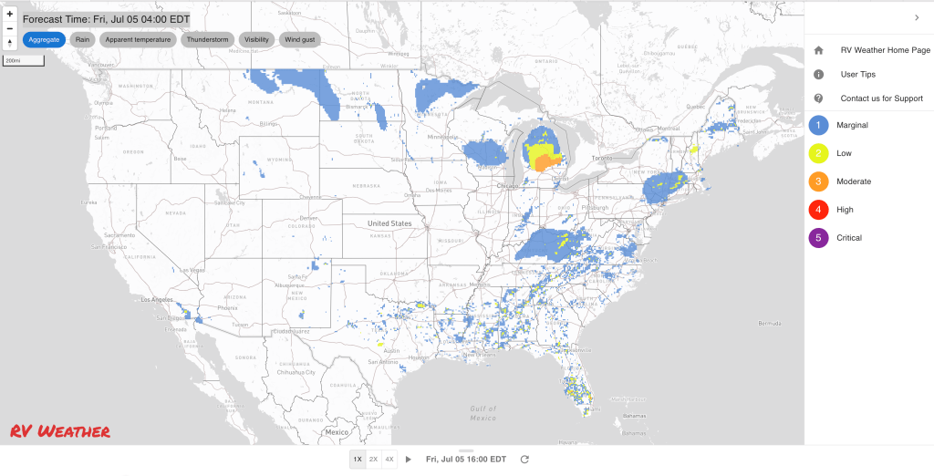
Graphics for Today


Current Severe Thunderstorm and Tornado Watches from the National Weather Service Storm Prediction Center


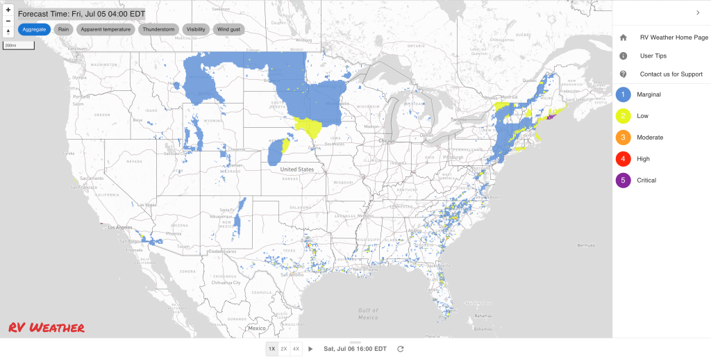
Graphics for Tomorrow


Three-day Summaries


Access to real-time road information:
Phone numbers and websites for road conditions in all 50 states. Courtesy of the Cheyenne WY Weather Forecast Office
Some useful links:
Thank you for using RVWeather.