
- Heavy showers and thunderstorms continue today along the coastal Carolinas.
- Potentially flooding rains continue throughout the weekend for the southeast Texas coast.
- Heat and a chance of severe thunderstorms today across much of the northern Plains.
From the RV Weather Field Office in State College PA:
These are the most significant weather impacts to RV travel over the next two to three days. I do not list every area of rain, showers, or breezy winds. It would be exhausting (for both of us!).
Weather Impacts Pacific Time Zone:
— Northern CA Sacramento Valley and surrounding foothills: Red Flag (fire danger) Warning today and early tonight. Wind gusts to 30 mph. I-5, CA-36, CA-44, CA-89, CA-99, CA-299 impacted.
— Central CA portions of the southern Sierra Nevada Range: Red Flag (fire danger) Warning today and early tonight. Wind gusts 30-40 mph. CA-178 impacted.
— Southern CA Mojave Desert Slopes: Wind Advisory this afternoon and tonight. Wind gusts to 45 mph. US-395, CA-14, CA-58 impacted.
— Interior southern and southeast CA deserts; Colorado Valley adjacent far southwestern AZ: Excessive Heat Warnings today. High temperatures 107-117 deg F with heat index values reaching the mid 120’s deg F. I-8, I-10, US-95 impacted.
Weather Impacts Mountain Time Zone:
— Portions of eastern and southeast ID: Red Flag (fire danger) Warnings this afternoon and evening. Wind gusts to 30 mph. I-15, US-20, US-26, US-93 impacted.
— Portions of north-central MT: Red Flag (fire danger) Warnings this afternoon and evening. Wind gusts to 35 mph. I-15, US-2, US-87 impacted.
— Portions of east-central and southeast WY: Heat Advisory today. High temperatures 101-107 deg F.
— Northwest UT and adjacent northeast NV: Strong to marginally severe thunderstorms possible today. Wind gusts are the primary hazard. I-15, I-80, I-84 potentially impacted.
— Much of central and southwest UT: Strong winds Saturday afternoon and evening. Wind gusts 30-35 mph. I-15, I-70, US-50, US-89 impacted.
— Far southwest AZ: Excessive Heat Warnings today. High temperatures 107 – 117 deg F with heat index values reaching the mid 120’s deg F. I-8, I-10, US-95 impacted.
— South-central and southeast AZ; adjacent southwest NM: Locally strong thunderstorms today may produce damaging wind gusts and possible dust storms. I-8, I-10, I-17, I-19 potentially impacted.
— Much of north-central, central and west-central NM: Flood Watches this afternoon and evening for monsoon showers and thunderstorms. Localized rainfall rates may reach 2 inches per hour resulting in flash flooding. I-25, I-40, US-54, US-60, US-64, US-285, US-380, US-550 impacted.
Weather Impacts Central Time Zone:
— Eastern ND; northwest MN: Isolated severe thunderstorms possible today and again on Saturday. Wind gusts, hail, and a tornado or two are possible. Thunderstorms are likely to be stronger on Saturday. I-29, I-94 potentially impacted.
— Eastern ND and adjacent northwest MN: Heat Advisory this afternoon and evening. Heat index values may reach 99 deg F.
— Northwest MN; southeast ND; northeast, central and south-central SD; far-western KS: Strong winds this afternoon and evening. Gusts 30-35 mph. I-29, I-70, I-90, I-94 impacted.
— Southern and eastern ND; western, central and southern MN; most of SD; central and eastern NE; central and western IA; north-central KS; northwest IA: Strong to severe thunderstorms possible on Sunday. I-29, I-35, I-80, I-90, I-94 potentially impacted.
— Central and southwest SD; western NE: Isolated severe thunderstorms possible today. Wind gusts are the primary hazard. I-90, US-20 potentially impacted.
— Portions of south-central SD: Heat Advisory today. Heat index values of 100 deg F.
— Eastern and south-central SD; central and southwest NE; parts of western KS: Strong winds Sunday afternoon and evening. Wind gusts around 30 mph. I-29, I-70, I-80, I-90 impacted.
— Northwest and west-central NE: Heat Advisory today. Heat index values may reach 101-107 deg F.
— Portions of western NE: Red Flag (fire danger) Warning this afternoon and evening. Wind gusts to 35 mph. I-80, US-20 impacted.
— Coastal and southeast TX north of Corpus Christi: Flood Watches continue through this afternoon. An additional 2-4 inches of rainfall is possible along the coast through the weekend, with lesser amounts inland. I-10, I-45 impacted.
Weather Impacts Eastern Time Zone:
— Southeast NC; northeast SC: Flood Watches continue through this evening. An additional inch or 2 of rainfall, especially along the coast, is possible on top of already saturated ground. I-20, I-40, I-95, US-17, US-70, US-74 potentially impacted.
Graphics for Today
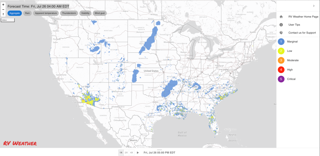


Current Severe Thunderstorm and Tornado Watches from the National Weather Service Storm Prediction Center


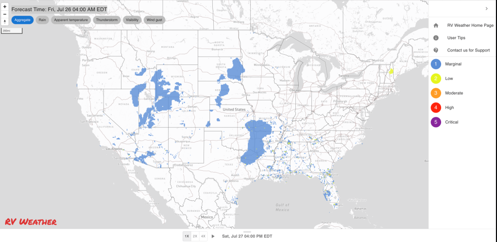
Graphics for Tomorrow


Three-day Summaries


Access to real-time road information:
Phone numbers and websites for road conditions in all 50 states. Courtesy of the Cheyenne WY Weather Forecast Office
Some useful links:
Thank you for using RVWeather.