


Planning to travel in the next seven days? Here’s what could impact your route.
- Although scattered severe thunderstorms persist across western Texas Oklahoma and the southern High Plains, the greater risk becomes flash flooding today and Thursday.
- Flash flooding concerns move to southern and eastern Texas and western Louisiana for the holiday weekend.
- Last day today of heat for the Northeast corridor.
Your route’s weather may vary from the general forecast — check your exact trip
48-hour access • No credit card required
Risk free – 30-day money-back guarantee
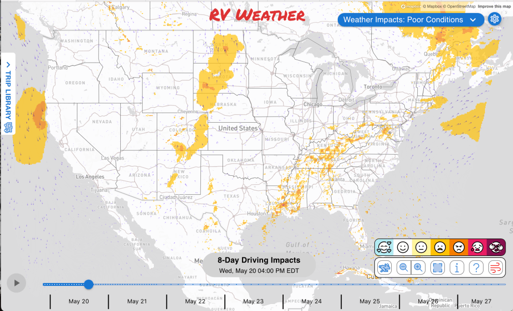
Significant travel weather for the next 2-3 days.
NEW: Extended forecast for the next 2 weeks now included!
Weather Impacts Pacific:
— No significant weather impacts to travel today or Thursday.
Weather Impacts Mountain:
— Lower and Central Yampa River Basins in Colorado, the South Laramie Range and nearby Carbon County mountain and basin areas in Wyoming, and the Arco/Mud Lake Desert in Idaho: Freeze Warnings through late morning, with sub-freezing temperatures as low as 13 degrees in parts of Wyoming, 23 degrees in northwest Colorado, and 30 degrees in eastern Idaho.
— South Laramie Range, Wyoming: Dense Fog Advisory through late morning, with visibility below one quarter mile in dense fog making driving hazardous. I-80, US-30, US-287 impacted.
— East-central and southeastern New Mexico: Scattered severe thunderstorms are possible this afternoon into evening. Thunderstorms may contain large hail and isolated severe wind gusts. I-40, US-54, US-60, US-62, US-70, US-82, US-84, US-180, US-285, US-380 potentially impacted.
— Southeastern Colorado and adjacent northeast New Mexico: Isolated severe thunderstorms are possible Thursday afternoon and evening, with a few stronger storms capable of large hail, damaging wind, and a low tornado risk near the Front Range and adjacent plains. I-70, US-24, US-40, US-50, US-56, US-160, US-287, US-385, US-400 potentially impacted.
Weather Impacts Central:
— Central and western Texas: Scattered severe thunderstorms are possible this afternoon into evening, with large hail and isolated severe wind gusts the primary hazards. I-10, I-20, I-27, US-59, US-60, US-62, US-67, US-70, US-79, US-82, US-83, US-84, US-87, US-90, US-180, US-190, US-277, US-285, US-380, US-385 potentially impacted.
— Central and southern Texas: Flash flooding is possible this afternoon into tonight as numerous showers and thunderstorms develop from south Texas through the Edwards Plateau, with 2 to 3 inches of rain possible and locally higher amounts near 5 inches, especially near the Del Rio portion of the Edwards Plateau. I-10, I-20, I-35, I-37, US-59, US-67, US-79, US-83, US-84, US-87, US-90, US-190, US-277, US-281, US-285, US-290, US-385 potentially impacted.
— Southwestern Kansas, central and western Oklahoma, and northern Texas: Scattered strong to severe storms are possible Friday afternoon and evening, with potential for large hail and damaging wind along and east of the dryline. The greatest risk of severe weather will be across central and western Oklahoma. I-20, I-27, I-35, I-40, I-44, US-50, US-54, US-56, US-60, US-62, US-64, US-67, US-70, US-82, US-83, US-84, US-87, US-180, US-183, US-277, US-281, US-283, US-287, US-380, US-400, US-412 potentially impacted.
— Coastal Texas from Aransas to Calhoun Counties: Coastal Flood Advisory beginning this morning through early evening, with minor coastal flooding expected and water covering lots, parks, and roads near the coast.
— Eastern Kansas, western Missouri, much of Oklahoma, much of Arkansas, western and northern Louisiana, and eastern Texas: Flash flooding is possible Thursday into Thursday night as excessive rainfall develops from the Southern Plains into the Piney Woods, creating high water and difficult travel in low-lying and flood-prone areas. I-10, I-14, I-20, I-29, I-30, I-35, I-37, I-40, I-44, I-45, I-49, I-69, I-69E, I-70 potentially impacted.
— Southeast Kansas into western and central Missouri: Flood Warnings continue into Friday evening in several river basins and low-water crossing areas, with flooding caused by excessive rainfall, minor to moderate river flooding, and high water in low-lying and flood-prone locations. Between 3 and 7 inches of rain have fallen in parts of the warned area. Roads and highways near I-29, I-35, I-44, I-49, I-70, US-36, US-54, US-63, US-65, US-77 may be impacted.
— South-central Louisiana near Lafayette and the Vermilion River: Flood Warning through Saturday morning, with river flooding and high water affecting low-lying roads and flood-prone locations. Highways near I-10, I-49, US-90, US-167 may be impacted.
— Southeastern Louisiana into southern Mississippi: Flash flooding is possible this afternoon into tonight, with heavy rainfall potential of 2 to 3 inches and locally higher amounts near 5 inches creating high-water risks in low-lying and flood-prone areas. I-10, I-12, I-55, I-59, US-49, US-61, US-84, US-90, US-98, US-190 potentially impacted.
Weather Impacts Eastern:
— Northern Lower Michigan: Freeze Watch late tonight through Thursday morning, with sub-freezing temperatures as low as 30 possible.
— Southern Indiana into north-central Kentucky: Flood Watch through this afternoon, with excessive rainfall continuing to make flooding possible and potentially creating high water in low-lying areas. Widespread heavy rainfall between 2 to 4 inches fell across the watch area Monday, with additional significant rainfall yesterday. I-64, I-65, US-31, US-421 potentially impacted.
— Crawford and Perry Counties in southern Indiana: FLASH FLOOD WARNING early this morning with additional rainfall amounts of 1 to 2 inches creating dangerous high water and rapidly changing road conditions. Roads and highways near I-64 may be impacted.
— Southeast Indiana, northern Kentucky, and southwest Ohio: Flood Advisories through morning, with flooding caused by excessive rainfall and minor flooding possible in low-lying and poor-drainage areas. Between 0.75 and 1.25 inches of rain have fallen. Additional rainfall amounts of 0.5 to 1 inch are possible. I-71, I-74, I-75, US-27, US-50, US-127, US-421 impacted.
— Southeastern Massachusetts, most of Rhode Island, parts of Connecticut, greater New York City area and Long Island, New Jersey, southern Pennsylvania, Delaware, Maryland, District of Columbia, West Virginia and adjacent southern Ohio, much of Virginia, eastern Kentucky: A few strong to severe thunderstorms are possible this afternoon into evening, with isolated severe gusts and hail producing short-duration difficult travel. I-26, I-64, I-66, I-68, I-70, I-75, I-76, I-77, I-78, I-79, I-80, I-81, I-83, I-84, I-86, I-87, I-91, I-95, I-97, I-99 potentially impacted.
— Much of southern New England, the New York City metro, New Jersey, southeast Pennsylvania, and northern Delaware: Heat Advisories through late evening, with heat index values generally in the middle 90s and up to 98 degrees in parts of New Jersey and the Philadelphia region.
— Inland Southeast Georgia into northern Florida and the South Carolina Lowcountry into Southeast Georgia: Locally dense fog this morning reducing visibility to one half mile or less near and north of the I-10 corridor and as low as one quarter mile in parts of the South Carolina Lowcountry and Southeast Georgia. I-10, I-16, I-75, I-95, US-1, US-17, US-23, US-25, US-27, US-41, US-84, US-280, US-301 impacted.
Outlook through Tuesday May 26th:
— Friday, May 22: northeastern Vermont, northern New Hampshire, and most of interior Maine: Frost or freeze concerns may create challenging conditions for early season RVers. Major highways potentially affected include I-91, I-95.
— Friday, May 22 through Monday, May 25: from much of Texas into the Lower Mississippi Valley and Tennessee Valley: Heavy rain may create localized flooding and reduced visibility. Major highways potentially affected include I-10, I-20, I-30, I-35, I-40, I-55.
Extended Outlook May 27th through June 2nd:
— Wednesday, May 27: most of Oklahoma, most of Texas, most of Arkansas, Louisiana, and western Mississippi: Heavy rain is likely, which may create localized flooding and reduced visibility. Major highways potentially affected include I-10, I-20, I-30, I-35, I-40, I-55.
— Wednesday, May 27 through Friday, May 29: from the southern Plains into the Lower Mississippi Valley, Southeast, and Mid-Atlantic: Heavy rain may develop, which could create localized flooding and reduced visibility. Major highways potentially affected include I-4, I-10, I-20, I-35, I-40, I-55, I-65, I-74, I-75, I-81, I-85, I-87, I-95.
Forecast Confidence for the Extended Outlook:
Confidence is reasonable for the earlier period, with generally good large-scale agreement through the weekend. Confidence decreases later in the outlook because model agreement is poorer and there is more uncertainty in how the western U.S. pattern evolves.
Looking for real-time road conditions? Here’s a link, courtesy of the Federal Highway Administration, to all the individual State 511 websites.
Your route’s weather may vary from the general forecast — check your exact trip
48-hour access • No credit card required
Risk free – 30-day money-back guarantee
Selected travel-relevant Weather Graphics


Graphics for Today


Current Severe Thunderstorm and Tornado Watches from the National Weather Service Storm Prediction Center


Hail Size Forecast for today and tomorrow

Wildfire Smoke Forecast for today and tomorrow

Graphics for Tomorrow


National Weather Map for the Day after Tomorrow

Three-day Summaries


Day 3 – Day 7 U.S. Significant Weather Outlook

Access to real-time road information:
Phone numbers and websites for road conditions in all 50 states. Courtesy of the Cheyenne WY Weather Forecast Office
Some useful links:
Thank you for using RVWeather.