


Planning to travel this week? Here’s what could impact your route.
- Dangerous heat covers much of the eastern half of the U.S. today through Saturday, with heat index values commonly 100–110°F and locally up to 115°F.
- Severe thunderstorms today and tonight could disrupt travel from the Plains and Upper Midwest to the Great Lakes, with damaging wind, large hail, and a few tornadoes possible.
- Flash flooding and repeated thunderstorms may create localized travel problems across southern Minnesota, northern Iowa, and Wisconsin today through Friday night.
Your route’s weather may vary from the general forecast — check your exact trip
48-hour access • No credit card required
Risk free – 30-day money-back guarantee
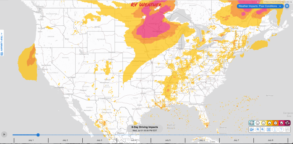
Significant travel weather for the next 2-3 days.
Weather Impacts Pacific
— No significant weather impacts to travel today or Thursday.
Weather Impacts Mountain:
— Central and western Montana: Isolated severe thunderstorms are possible today and tonight, with a few storms capable of damaging wind gusts. I-15, I-90, US-2, US-12, US-87, US-89, US-93, US-191 potentially impacted.
— Eastern Colorado and eastern New Mexico: Scattered severe thunderstorms are possible today and tonight, with damaging wind gusts and hail. I-40, I-70, US-24, US-34, US-36, US-40, US-50, US-54, US-56, US-60, US-62, US-64, US-70, US-82, US-84, US-87, US-160, US-285, US-287, US-380, US-385, US-400, US-412 potentially impacted.
— Southeastern Utah and western Colorado into central and southern Colorado: Red Flag Warnings continue today from late morning or midday through late evening, with southwest winds 15 to 25 mph, gusts up to 30 to 40 mph, relative humidity as low as 5 to 8 percent, and rapid fire spread possible. I-25, I-70, US-24, US-40, US-50, US-84, US-160 impacted.
— Central and southern Colorado: Red Flag Warnings begins Thursday morning and continue through early Friday, with gusts up to 35 mph and low humidity keeping fire danger elevated. I-25, US-24, US-50, US-85, US-160 impacted.
— Eastern Montana, northeastern Wyoming, and eastern Colorado: Strong to severe thunderstorms are possible Thursday, accompanied by damaging wind gusts , large hail, and a tornado or two. The greatest risk of severe weather will be across far-eastern Montana. I-25, I-70, I-76, I-80, I-90, I-94 potentially impacted.
— Eastern Montana and eastern Wyoming: Isolated severe thunderstorms are possible Friday. I-25, I-90, I-94, US-2, US-12, US-14, US-16, US-18, US-20, US-26, US-85, US-212 potentially impacted.
Weather Impacts Central
— Parts of Wisconsin, most of Iowa, Illinois, northwest Indiana, central and eastern Kansas, Missouri, eastern Arkansas and the I-40 corridor in Arkansas, Kentucky, Tennessee, eastern Louisiana, Mississippi, and much of Alabama: Extreme Heat Warnings and Advisories today through Saturday, with heat index values commonly 100 to 110 and locally 105 to 115. Nighttime lows in parts of Iowa and Illinois may not fall below the mid to upper 70s. I-20, I-22, I-24, I-29, I-35, I-39, I-40, I-41, I-43, I-44, I-49, I-55, I-57, I-59, I-64, I-65, I-69, I-70, I-72, I-74, I-75, I-80, I-88, I-90, I-94 impacted.
— North Dakota, South Dakota, most of Nebraska, western Kansas, central and southern Minnesota, most of Iowa, Wisconsin, and northern Illinois: Strong to severe thunderstorms are possible Thursday, with damaging wind, large hail, and a tornado risk. The greatest risk of severe weather will be across much of North and South Dakota, northern Nebraska, southern Minnesota, central and southern Wisconsin, and Iowa along and north of I-80. I-29, I-35, I-35E, I-35W, I-39, I-41, I-43, I-55, I-57, I-70, I-74, I-76, I-80, I-88, I-90, I-94 potentially impacted.
— North Dakota, South Dakota, most of Nebraska, most of Minnesota, Wisconsin, Iowa, much of Illinois, and northern Missouri: Isolated to scattered severe thunderstorms are possible Friday. The greatest risk of severe weather will be across southern South Dakota and northern Nebraska. I-29, I-35, I-35E, I-35W, I-39, I-41, I-43, I-55, I-57, I-70, I-72, I-74, I-76, I-80, I-88, I-90, I-94 potentially impacted.
— Eastern South Dakota, central and eastern Nebraska, western and central Kansas, the Oklahoma Panhandle, northwestern Texas, much of Minnesota, Wisconsin, and much of Iowa: Scattered severe thunderstorms are forecast for today and tonight, with damaging wind, large hail, and a few tornadoes. The greatest risk of severe weather will be across southern Minnesota and central Wisconsin, and also western Kansas. I-27, I-29, I-35, I-35E, I-35W, I-39, I-40, I-41, I-43, I-70, I-80, I-90, I-94 potentially impacted.
— Eastern South Dakota, southern Minnesota, and northwestern Iowa: Flash flooding is possible Thursday into Thursday night where repeated thunderstorms may produce isolated flash-flooding, especially where heavy rain overlaps areas hit earlier. I-29, I-35, I-90, US-12, US-14, US-18, US-20, US-59, US-61, US-63, US-69, US-71, US-81, US-169, US-212, US-281 potentially impacted.
— Southeast Minnesota and central Wisconsin: SEVERE THUNDERSTORM WARNINGS early this morning, with storms moving northeast at 45 mph, 60 mph wind gusts, quarter-size hail, and hail damage to vehicles expected. I-90, I-94 impacted.
— Southern Minnesota, northern Iowa, and central and northeast Wisconsin: Flash flooding is possible today into tonight as thunderstorms focus along a boundary, with localized rainfall rates of 1 to 2 inches per hour possible. I-29, I-35, I-35E, I-35W, I-39, I-41, I-43, I-90, I-94 potentially impacted.
— Southern Minnesota, northern Iowa, and central and southern Wisconsin: Flash flooding is possible Friday into Friday night, with locally intense rainfall rates. I-35, I-35E, I-39, I-41, I-43, I-90, I-94 potentially impacted.
— Northeast Wisconsin: Dense fog continues through late morning, with visibilities as low as one-half to one-quarter mile and sudden visibility drops over short distances. I-39, US-2, US-8, US-45, US-51 impacted.
— Tennessee, northern Mississippi, and northern and central Alabama: Isolated severe thunderstorms are possible Thursday, with a few stronger storms capable of damaging wind gusts. I-20, I-22, I-24, I-40, I-55, I-59, I-65, I-69, I-75, I-85 potentially impacted.
— Much of Louisiana, southeast Arkansas, Mississippi, western, central and northern Alabama and adjacent northwest Georgia: Isolated severe thunderstorms are possible today and tonight, with localized damaging wind gusts possible in stronger storms. I-10, I-12, I-20, I-22, I-24, I-49, I-55, I-59, I-65, I-75 potentially impacted.
Weather Impacts Eastern:
— Michigan Lower Peninsula, Indiana, Ohio, the Ohio Valley, central Appalachians, Tennessee, western North Carolina, and northwest Georgia: Extreme Heat Warnings and Advisories today through Friday depending, with heat index values commonly 101 to 110, and locally 110 to 115. I-64, I-65, I-69, I-70, I-71, I-75, I-76, I-77, I-79, I-80, I-90, I-94, I-96 impacted.
— Virginia, Maryland, District of Columbia, West Virginia, Pennsylvania, New Jersey, Delaware, New York, Connecticut, Massachusetts, Vermont, New Hampshire, and most of Maine: Extreme Heat Warnings, Watches and Advisories today through Saturday, with heat index values mostly 95 to 111, but with some places seeing values up to 115 deg F. Southern New England’s worst heat is expected Thursday and Friday. I-64, I-66, I-68, I-70, I-76, I-78, I-80, I-81, I-83, I-84, I-86, I-87, I-88, I-89, I-90, I-91, I-93, I-95, I-97, I-99 impacted.
— Michigan: Scattered severe thunderstorms are forecast today and tonight, with damaging wind gusts to 80 mph, along with isolated large to very large hail and a few tornadoes. The greatest risk of severe weather will be across the northern Michigan Lower Peninsula. I-69, I-75, I-94, I-96, US-2, US-8, US-10, US-23, US-31, US-41, US-45, US-51, US-127, US-131, US-141 potentially impacted.
— Michigan, Upstate New York, most of Vermont and New Hampshire, and much of Maine: Strong to severe thunderstorms are possible Thursday, with damaging wind and hail the primary hazards.locally supported. I-69, I-75, I-81, I-87, I-89, I-90, I-91, I-93, I-94, I-95, I-96 potentially impacted.
— Michigan Lower Peninsula, most of Indiana, Ohio and adjacent north-central Kentucky, most of West Virginia, western and southern New York, Pennsylvania, New Jersey, Maryland, District of Columbia, Delaware, central and northern Virginia, and the DELMARVA Peninsula: Isolated severe thunderstorms are possible Friday. I-57, I-64, I-65, I-66, I-68, I-69, I-70, I-71, I-74, I-75, I-76, I-77, I-78, I-79, I-80, I-81, I-83, I-84, I-86, I-87, I-88, I-90, I-94, I-95, I-96, I-97, I-99 potentially impacted.
— Southwest Ohio and Kentucky river valleys: Patchy dense fog continues through late morning. I-64, I-71, I-74, I-75 impacted.
— Much of eastern Tennessee, southwestern North Carolina and northern and northwestern Georgia: Isolated severe thunderstorms are possible Thursday, with strong wind gusts the primary hazard. I-20, I-24, I-26, I-40, I-59, I-75, I-81, I-85 potentially impacted.
— Maine, New Hampshire, Vermont, New York, Connecticut, most of Massachusetts, north-central and eastern Pennsylvania, and northern New Jersey: Scattered severe thunderstorms are possible today and tonight, with damaging wind and hail the primary hazards. I-76, I-78, I-80, I-81, I-84, I-86, I-87, I-88, I-89, I-90, I-91, I-93, I-95, I-99 potentially impacted.
— Anne Arundel County shoreline, Maryland: Coastal Flood Advisory continues through late morning, with up to one-half foot of inundation above ground level in low-lying areas around high tide.
Outlook Friday July 3rd through Tuesday July 7th:
— Friday, July 3: portions of the central Plains, Upper Midwest, and Great Lakes: Heat concerns may create challenging conditions. Major highways potentially affected include I-29, I-35, I-55, I-65, I-70, I-74, I-75, I-80, I-90, I-94.
— Friday, July 3: Upstate New York, Vermont, New Hampshire, and much of Maine: Heat concerns may create challenging conditions. Major highways potentially affected include I-81, I-87, I-90, I-91, I-95.
— Friday, July 3 through Saturday, July 4: portions of the northern Plains, Upper Midwest, and Great Lakes: Heavy rain may create localized flooding and reduced visibility. Major highways potentially affected include I-29, I-35, I-80, I-90, I-94.
— Friday, July 3 through Saturday, July 4: from the central Plains and Mid-Mississippi Valley into the Ohio Valley, central Appalachians, and Northeast as far north as coastal Maine: Heat concerns may create challenging conditions. Major highways potentially affected include I-20, I-30, I-35, I-40, I-55, I-64, I-65, I-70, I-71, I-74, I-75, I-76, I-79, I-80, I-81, I-84, I-87, I-90, I-91, I-95.
— Friday, July 3 through Sunday, July 5: from the southern Plains and Lower Mississippi Valley into the Southeast, central Appalachians, and Mid-Atlantic: Heat concerns may create challenging conditions. Major highways potentially affected include I-10, I-20, I-30, I-35, I-40, I-55, I-64, I-65, I-70, I-74, I-75, I-76, I-79, I-80, I-81, I-85, I-87, I-95.
— Friday, July 3 through Monday, July 6: portions of the Southeast from Alabama and Florida into the Carolinas and southeastern Virginia: Heat concerns may create challenging conditions. Major highways potentially affected include I-4, I-10, I-20, I-40, I-64, I-65, I-74, I-75, I-85, I-87, I-95.
Extended Outlook July 8th through July 14th:
— Wednesday, July 8 through Friday, July 10: much of the Interior West, Rockies, Plains, and Upper Midwest: Extreme heat may develop, which could create challenging travel conditions. Major highways potentially affected include I-8, I-10, I-15, I-25, I-29, I-35, I-40, I-70, I-74, I-76, I-80, I-84, I-90, I-94.
— Wednesday, July 8 through Friday, July 10: northeastern Florida, eastern Georgia, South Carolina, and most of North Carolina: Heavy precipitation may develop, which could create localized flooding and reduced visibility. Major highways potentially affected include I-20, I-40, I-74, I-85, I-87, I-95.
— Wednesday, July 8 through Sunday, July 12: portions of the central Gulf Coast and Florida: Extreme heat may develop, which could create challenging travel conditions. Major highways potentially affected include I-4, I-10, I-55, I-65, I-75, I-95.
— Wednesday, July 8 through Tuesday, July 14: much of western Oregon and California: Strong winds may develop, which could create hazardous crosswinds for high-profile vehicles. Major highways potentially affected include I-5, I-10, I-80, US-101, CA-1.
Forecast Confidence for the Extended Outlook:
Confidence is average for the earlier period, with generally good large-scale agreement on the pattern but some uncertainty in how quickly the heat breaks down and how western energy evolves. Confidence decreases later in the outlook because of greater model disagreement and weaker or conflicting temperature and precipitation signals across large portions of the forecast area.
Looking for real-time road conditions? Here’s a link, courtesy of the Federal Highway Administration, to all the individual State 511 websites.
Your route’s weather may vary from the general forecast — check your exact trip
48-hour access • No credit card required
Risk free – 30-day money-back guarantee
Selected travel-relevant Weather Graphics


Graphics for Today


Current Severe Thunderstorm and Tornado Watches from the National Weather Service Storm Prediction Center


Hail Size Forecast for today and tomorrow

Wildfire Smoke Forecast for today and tomorrow

Graphics for Tomorrow


National Weather Map for the Day after Tomorrow

Three-day Summaries


Day 3 – Day 7 U.S. Significant Weather Outlook

Access to real-time road information:
Phone numbers and websites for road conditions in all 50 states. Courtesy of the Cheyenne WY Weather Forecast Office
Some useful links:
Thank you for using RVWeather.