


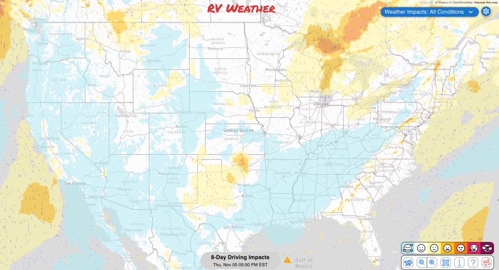
Planning to travel this week? Here’s what could impact your route.
- Heavy rain may bring 2–4 inches and flooding to coastal Massachusetts and most of Rhode Island late tonight through Saturday morning.
- A few strong to severe storms could bring damaging gusts and an isolated brief tornado to parts of eastern Virginia and the Carolinas Friday.
- Heavy precipitation, mountain snow and high winds may disrupt travel in parts of the West November 12–18.
Your route’s weather may vary from the general forecast — check your exact trip
This free daily forecast is separate from a paid RV Weather SureRoute subscription. SureRoute checks the weather along your specific route and travel timing.
48-hour access • No credit card required
Risk-free · 30-day money-back guarantee
Significant travel weather for the next 2-3 days.
Weather Impacts Pacific:
— Parts of eastern Washington, including the Kittitas and Yakima valleys, Moses Lake area, and Waterville Plateau: A Dense Fog Advisory covers the Kittitas and Yakima valleys through late morning, with visibility as low as one-quarter mile. Patchy dense fog with similar visibility has also been observed this morning around Moses Lake and the Waterville Plateau. Routes potentially affected: I-82, I-90, US-2, US-12, US-97.
— Coastal portions of Washington and parts of Washington’s Puget Lowland: Wind Advisories are in effect Friday. South winds of 20 to 30 mph with gusts up to 50 mph begin early, ending around midday on the northern Washington coast and during the afternoon elsewhere along the coast and in the Puget Lowland; downed limbs and a few power outages may result. Routes potentially affected: I-5, US-101.
— Coastal portions of Northern and Central California, parts of California’s Central Coast, and parts of the Bay Area: Coastal Flood Advisories are in effect through Nov. 13 for the Central Coast and Bay Area, while the advisory across coastal Northern and Central California runs Saturday through Tuesday. Up to 1.6 feet of inundation is possible in low-lying shoreline and tidal areas; 12- to 16-foot breaking waves, sneaker waves and strong rip currents are expected through Monday on affected Pacific-facing shores.
— Parts of Southern California Coast: A Coastal Flood Advisory is in effect Friday through Tuesday, with minor to locally moderate flooding of lots, parks and roads and isolated road closures. The highest tides are expected Sunday and Monday, accompanied by dangerous rip currents and elevated surf.
Weather Impacts Mountain:
— Parts of northwestern Montana, including the East Glacier Park Region, Northern High Plains, and Rocky Mountain Front: A High Wind Watch is in effect Friday afternoon through Saturday morning. Westerly winds of 35 to 50 mph could gust to 70 mph over the plains and 80 mph along the immediate eastern slopes of the Rocky Mountain Front, with the strongest winds Friday night into early Saturday and isolated power outages possible. Routes potentially affected: I-15, US-2, US-89.
— Parts of northeastern and north-central Arizona, including Tuba City: A Flood Warning continues through early evening. Flooding is occurring along Moenkopi Wash, where water remains near moderate flood stage but is gradually falling; lower Moenkopi Village and nearby crop fields may remain affected. Routes potentially affected: US-160.
— Parts of southeastern Arizona along the Gila River near Calva: A Flood Advisory continues through this evening. Elevated water from last weekend’s rain is flooding low-lying riparian areas, though the river is expected to fall below action stage by late afternoon or early evening. Routes potentially affected: US-70.
— Parts of central and south-central New Mexico along the Rio Puerco and Rio Grande: A Flood Advisory is in effect through Saturday morning. Rising river levels are causing arroyo and small-stream flooding, with minor flooding possible as the Rio Puerco crests late tonight. Routes potentially affected: I-25, US-60.
Weather Impacts Central:
— Western North Dakota: A Dense Fog Advisory remains in effect through midday, with visibility of one-quarter to one-half mile. Routes potentially affected: I-94, US-2, US-52, US-85.
— Parts of east-central Nebraska, including Clarks: A Flood Warning continues through Friday morning. Water levels at Silver Creek are slowly falling, but flooding of streams and other low-lying locations will continue; no additional rainfall is expected. Routes potentially affected: US-30.
Weather Impacts East:
— Parts of southeastern Tennessee along the Ocoee River: A Flood Warning is in effect through the afternoon. Runoff moving down the Ocoee River may cause additional flooding of rivers, creeks, streams and low-lying areas. Routes potentially affected: I-75, US-64.
— Coastal portions of Massachusetts and most of Rhode Island: A Flood Watch is in effect from late tonight through Saturday morning. Periods of heavy rain may produce 2 to 4 inches and flooding in urban, poor-drainage and other low-lying areas. Routes potentially affected: I-95, US-1, US-6, US-44.
— Coastal portions of Maryland, including Annapolis: A Coastal Flood Advisory is in effect through early evening, especially around afternoon high tide. Up to one-half foot of inundation is expected in low-lying shoreline areas, with water potentially ponding around Annapolis City Dock.
— Parts of Virginia’s Tidewater and parts of its Eastern Shore, eastern North Carolina and coastal North Carolina, and parts of Eastern South Carolina: A few strong to severe storms are possible Friday. Isolated organized storms may produce damaging gusts and perhaps a brief tornado. Routes potentially affected: I-20, I-40, I-64, I-74, I-87, I-95.
— Parts of west-central Florida and parts of southwestern Florida: A Flood Warning remains in effect until further notice. Major flooding is occurring and forecast on the Peace River near Arcadia, which is expected to crest near 16.4 feet this evening; at this level, dozens of homes in River Acres are flooded. Routes potentially affected: US-17.
— Parts of northeastern Florida: A Coastal Flood Advisory continues through early Friday morning. Minor flooding of lots, parks and roads is expected, with isolated road closures possible.
Tropical Weather Outlook for the next 7 days:
— Western and Central Atlantic: A broad non-tropical low south of Bermuda could gradually acquire subtropical characteristics through the weekend while moving slowly east. Formation chances are 30 percent within 48 hours and 50 percent within seven days, with conditions becoming unfavorable early next week.
Extended Hazard Outlook
Outlook Sunday, November 8th through Wednesday, November 11th:
— Sunday, November 8 through Monday, November 9: From southeastern Missouri and northeastern Arkansas through the Ohio and Tennessee Valleys into the southern Appalachians: Frost or freeze concerns may create challenging conditions for early-season RVers. Major highways potentially affected include I-40, I-55, I-64, I-65, I-71, I-75, I-81.
— Tuesday, November 10 through Wednesday, November 11: Northern Washington: Heavy precipitation may create localized flooding and difficult travel. Major highways potentially affected include I-5.
— Wednesday, November 11: Western Oregon and northwestern California: Heavy rain may create localized flooding and reduced visibility.
Extended Outlook Thursday, November 12th through Wednesday, November 18th:
— Thursday, November 12 through Wednesday, November 18: Much of the West Coast, portions of Nevada, and the Southwest into Utah and southwestern Colorado: Heavy precipitation may develop, creating localized flooding and difficult travel. Heavy precipitation is likely Thursday, November 12 through Sunday, November 15 across most of Washington and California, much of Oregon, and small portions of northwestern Nevada. Major highways potentially affected include I-5, I-8, I-10, I-15, I-25, I-40, I-80, I-84, I-90.
— Thursday, November 12 through Wednesday, November 18: Much of Washington, western Oregon, portions of California, and northwestern Nevada: Heavy snow may develop, creating difficult travel over higher terrain and mountain passes. Heavy snow is likely Thursday, November 12 through Sunday, November 15 across portions of southwestern Oregon and northwestern California and small portions of northwestern Nevada. Major highways potentially affected include I-5, I-80, I-84, I-90.
— Thursday, November 12 through Wednesday, November 18: Across the West from the West Coast through the Rockies, extending into western Texas: Strong winds may develop, creating hazardous crosswinds for high-profile vehicles, including near Snoqualmie Pass, Deadman Pass, Donner Pass, and Cajon Pass. High winds are likely Thursday, November 12 through Sunday, November 15 across small parts of northwestern Washington and parts of western Oregon and northwestern California. Major highways potentially affected include I-5, I-8, I-10, I-15, I-25, I-40, I-70, I-76, I-80, I-84, I-90, I-94.
— Thursday, November 12 through Wednesday, November 18: Northern and central Rockies and northeastern Washington: Heavy snow may develop, creating difficult travel over higher terrain and mountain passes. Major highways potentially affected include I-15, I-25, I-70, I-76, I-80, I-84, I-90.
— Thursday, November 12: From the central Appalachians and Mid-Atlantic through New York and New England: Strong winds may develop, creating hazardous crosswinds for high-profile vehicles. Major highways potentially affected include I-70, I-76, I-79, I-80, I-81, I-84, I-87, I-90, I-91, I-95.
Confidence in the Extended Outlook:
Confidence is generally good, with reasonably good agreement on the large-scale pattern. Uncertainty remains in the placement of the West Coast moisture plume and in some temperature and precipitation details later in the outlook.
Looking for real-time road conditions? Here’s a link, courtesy of the Federal Highway Administration, to all the individual State 511 websites.
Your route’s weather may vary from the general forecast — check your exact trip
48-hour access • No credit card required
Risk-free · 30-day money-back guarantee
Weather Maps and National Outlooks
For current NWS hazards, severe-storm and hurricane outlooks, heavy-rain risk, wind, smoke, heat/winter risk, and other always-updating weather graphics, visit:
Access to real-time road information:
Phone numbers and websites for road conditions in all 50 states. Courtesy of the Cheyenne WY Weather Forecast Office
Some useful links:
Thank you for using RVWeather.