


Planning to travel in the next seven days? Here’s what could impact your route.
- A wet holiday weekend for many from southern and eastern Texas, through the lower Mississippi, Tennessee, and Ohio Valleys into the Mid-Atlantic states, Pennsylvania and New Jersey.
- Mountain snow above 8000 feet could slow travel over southern Montana and northern Wyoming passes
- Severe thunderstorms with hail this afternoon across the High Plains of Colorado.
Your route’s weather may vary from the general forecast — check your exact trip
48-hour access • No credit card required
Risk free – 30-day money-back guarantee
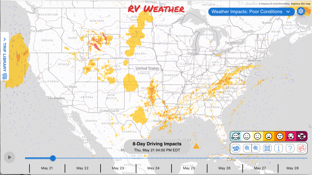
Significant travel weather for the next 2-3 days.
NEW: Extended forecast for the next 2 weeks now included!
Weather Impacts Pacific:
— No significant weather impacts to travel today or Friday.
Weather Impacts Mountain:
— Absaroka/Beartooth Mountains in Montana: Winter Storm Warning through early evening, with 8 to 15 inches of snow mainly on north-facing slopes above 6500 feet and north winds gusting as high as 30 mph. Beartooth Pass may see several inches of snow, creating snowpacked or difficult high-country travel. US-89, US-212 impacted.
— Pryor/Northern Bighorn Mountains in Montana and Northeast Bighorn Mountains in Wyoming: Winter Weather Advisory through late evening, with 5 to 10 inches of snow and north winds gusting as high as 30 mph. Expect wintry travel conditions on US-14 through Burgess Junction and slower travel over higher terrain. US-14 impacted.
— Southeast Wyoming, eastern Colorado and eastern New Mexico: Severe thunderstorms are expected this afternoon into early evening, with large hail, isolated severe wind gusts, and possibly a tornado; storms may develop from higher terrain near Denver and Colorado Springs. The greatest risk of severe weather will be across eastern Colorado. I-25, I-40, I-70, I-76, I-80, US-6, US-24, US-30, US-34, US-36, US-40, US-50, US-54, US-56, US-60, US-62, US-64, US-70, US-82, US-84, US-85, US-87, US-160, US-287, US-380, US-385, US-400, US-412 potentially impacted.
— Paradox Valley and the Colorado River Basin in eastern Utah and western Colorado: Red Flag Warning beginning around midday through early evening, with west winds 10 to 20 mph, gusts up to 30 mph. I-70, US-6, US-50, US-191 impacted.
Weather Impacts Central:
— South Texas from Duval and Jim Wells Counties east toward Kleberg, Nueces, and San Patricio Counties: FLASH FLOOD WARNING through mid-morning, with 1 to 3.5 inches of rain already fallen in parts of the warned areas, rainfall rates of 1 to 3 inches in 1 hour; additional rainfall up to 2 inches possible. Flash flooding may create high water in low-lying areas, flooded roads, and quickly deteriorating travel. I-37, I-69E, US-77, US-281 impacted.
— Southeast Alabama and the Florida Panhandle: Dense Fog Advisory through late morning, with visibility one quarter to one half mile. Low visibility could make driving hazardous, especially for larger RVs and trailers on faster roads. I-10, US-84, US-98, US-231, US-431 impacted.
— Missouri river corridors from northwest through central and western Missouri: Flood Warnings continue through late tonight into Sunday morning, with minor to moderate flooding on the 102, Platte, Blackwater, Grand, Missouri, Bourbeuse, Moreau, Little Osage, and Osage River areas; the 102 River near Rosendale has moderate flooding approaching the flood of record. Expect water over low roads, closed low-water crossings, and delays near river-bottom routes. Roads near I-29, I-35, I-44, I-49, I-70, US-36, US-65 impacted.
— Northern Mississippi near Chickasaw and Monroe Counties: Flood Advisory through morning, with excessive rainfall causing minor flooding in low-lying and poor-drainage areas and elevated stream flows. Slow travel is possible where water covers secondary roads. Roads near US-45 potentially impacted.
— South-central, southeast, and South Texas: Flood Watches through Monday morning and Monday evening, with excessive rainfall possible over several days. Fairly widespread totals of 2 to 4 inches can be expected with localized totals of up to 6 inches through Monday. Excessive runoff may flood rivers, creeks, streams, low-lying roads, and other flood-prone locations, making route timing important for RV travel. I-10, I-35, I-37, I-45, I-69, I-69E, US-59, US-77, US-83, US-87, US-281 potentially impacted.
— Western Nebraska, far-western Kansas, Oklahoma Panhandle, and much of central and western Texas: Severe thunderstorms are expected this afternoon into evening, with a threat for large hail, isolated severe gusts, and possibly a tornado. I-10, I-20, I-27, I-40, I-70, I-76, I-80 potentially impacted.
— Western and central Oklahoma, adjacent southwestern Kansas, and the Texas Panhandle and north-centralTexas: Scattered strong to severe storms are possible Friday afternoon into evening, with potential for large hail and damaging wind. The greatest risk of severe weather will be across western Oklahoma and the Texas Panhandle. I-20, I-27, I-30, I-35, I-40, I-44 potentially impacted.
— Central and eastern Oklahoma, northeastern Texas, northwestArkansas, and southeastern Kansa: Flash flooding is possible today into early Friday as rounds of training thunderstorms develop. 1-3 inch rainfall totals will be common. I-20, I-30, I-35, I-40, I-44, I-45, I-49 potentially impacted.
— Southwestern Arkansas, western Louisiana, and eastern Texas: Flash flooding is possible Saturday into early Sunday. 2-6 inches of rainfall are possible in many areas. I-2, I-10, I-14, I-20, I-30, I-35, I-37, I-45, I-49, I-69, I-69C, I-69E potentially impacted.
Weather Impacts Eastern:
— Central and southern Indiana river corridors: Flood Warnings continue through late tonight into Sunday morning, with multiple rounds of recent heavy rain and additional light to moderate rain producing minor lowland flooding along the Driftwood River, Youngs Creek, and White River locations. Expect high water in low-lying areas and possible delays near river crossings. Roads near I-65, I-69, US-31 may be impacted.
— Much of Kentucky and adjacent southeast Indiana: A few severe storms are possible Friday afternoon into evening as storms develop near a warm front, with isolated severe wind or tornado potential. I-64, I-65, I-71, I-75, US-25E, US-27, US-31, US-31E, US-50, US-60, US-68, US-127, US-421 potentially impacted.
— Northern New York, northeastern Vermont, northern New Hampshire, and western Maine: Freeze Warning beginning late tonight through Friday morning, with sub-freezing temperatures as low as 26 to 28 degrees expected.
— Duplin County, North Carolina: Patchy dense fog through late morning, with visibility of one quarter mile or less early this morning. I-40 impacted.
— Inland northeast Florida and inland southeast Georgia: Patchy dense fog this morning, with visibilities of one half mile or less along the US-301 corridor from inland Duval County northward across inland southeast Georgia. I-10, I-95, US-1, US-23, US-25, US-84, US-301 impacted.
Outlook through Wednesday May 27th:
— Saturday, May 23 through Monday, May 25: from southeastern Oklahoma and much of Texas across the Lower Mississippi Valley into portions of the lower Ohio Valley, Tennessee, and northwestern Alabama: Heavy rains may create localized flooding and reduced visibility. Major highways potentially affected include I-10, I-20, I-30, I-35, I-40, I-55, I-65.
— Tuesday, May 26: much of southern California and small portions of western Nevada: Strong winds may create hazardous crosswinds for high-profile vehicles, especially over higher terrain including Cajon Pass and San Gorgonio Pass. Major highways potentially affected include I-5, I-8, I-10, I-15, I-40, US-395, CA-14, CA-58.
— Tuesday, May 26: from the northern High Plains into the central Plains, including eastern Colorado, much of South Dakota and western Nebraska, and northwestern Kansas: Strong winds may create hazardous crosswinds for high-profile vehicles. Major highways potentially affected include I-70, I-76, I-80, I-90.
Extended Outlook May 28th through June 3rd:
— Thursday, May 28 through Saturday, May 30: portions of western Oregon and northwestern California: Strong winds may develop, which could create hazardous crosswinds for high-profile vehicles. Major highways potentially affected include US-101, CA-1.
— Thursday, May 28 through Saturday, May 30: much of the Intermountain West and central Rockies into the northern and central Plains: Strong winds may develop, which could create hazardous crosswinds for high-profile vehicles, especially over higher terrain including Homestake Pass, Bozeman Pass, Parleys Summit, and Emigrant Pass. Major highways potentially affected include I-15, I-25, I-40, I-70, I-76, I-80, I-84, I-90, I-94.
— Thursday, May 28 through Saturday, May 30: from Oklahoma and Texas through the Lower Mississippi Valley and Southeast into the Carolinas and Virginia: Heavy rain may develop, which could create localized flooding and reduced visibility. Major highways potentially affected include I-4, I-10, I-20, I-30, I-35, I-40, I-55, I-65, I-74, I-75, I-81, I-85, I-87, I-95.
Forecast Confidence for the Extended Outlook:
Confidence is average overall. The earlier period has generally reasonable large-scale agreement, though smaller-scale details could still shift the placement of heavier precipitation. Confidence remains average later in the outlook, with fair model agreement but added uncertainty tied to how the western U.S. pattern evolves.
Looking for real-time road conditions? Here’s a link, courtesy of the Federal Highway Administration, to all the individual State 511 websites.
Your route’s weather may vary from the general forecast — check your exact trip
48-hour access • No credit card required
Risk free – 30-day money-back guarantee
Selected travel-relevant Weather Graphics


Graphics for Today


Current Severe Thunderstorm and Tornado Watches from the National Weather Service Storm Prediction Center


Hail Size Forecast for today and tomorrow

Wildfire Smoke Forecast for today and tomorrow

Graphics for Tomorrow


National Weather Map for the Day after Tomorrow

Three-day Summaries


Day 3 – Day 7 U.S. Significant Weather Outlook

Access to real-time road information:
Phone numbers and websites for road conditions in all 50 states. Courtesy of the Cheyenne WY Weather Forecast Office
Some useful links:
Thank you for using RVWeather.