


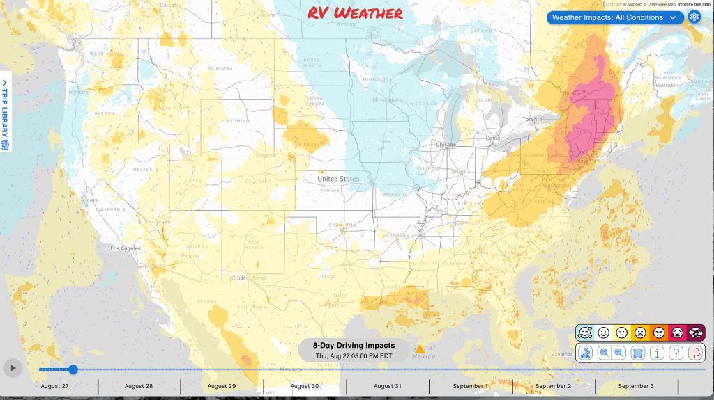
Planning to travel this week? Here’s what could impact your route.
- Scattered severe storms and flash flooding threaten travel across the Northeast and Mid-Atlantic today, with damaging winds, large hail, a tornado or two, and locally intense rainfall possible.
- Large to very large hail and severe wind gusts may disrupt Central Plains travel across South Dakota, Nebraska, and western Kansas today.
- The heat continues across the desert Southwest through Saturday and localized temperatures near 118 degrees in the Colorado River Valley. The excessive heat moves slowly eastward starting this weekend.
Your route’s weather may vary from the general forecast — check your exact trip
This free daily forecast is separate from a paid RV Weather SureRoute subscription. SureRoute checks the weather along your specific route and travel timing.
48-hour access • No credit card required
Risk-free · 30-day money-back guarantee
Significant travel weather for the next 2-3 days.
Weather Impacts Pacific:
— North-central Washington: A Red Flag Warning today, with wind gusts up to 35 mph supporting rapid fire spread. US-2, US-97 impacted.
— South-central and southeastern Oregon, southwestern Idaho, and northeastern California: Red Flag Warnings today, with wind gusts up to 40 mph supporting rapid fire spread. US-20, US-95, US-97, US-395, CA-139 impacted.
— Northeastern Nevada: Isolated severe thunderstorms are possible today, with damaging wind possible. I-80, US-93 potentially impacted.
— Southern Nevada, central and Southern California, and western Arizona, including Death Valley and eastern Joshua Tree National Parks: Extreme Heat Warnings and Heat Advisories through Saturday. Temperatures may reach115 to 118 degrees in Death Valley and the Colorado River Valley, 112 to 116 in Southern California deserts, 110 in inland areas, and 102 along the Southern California coast, making daytime travel and outdoor stops more difficult. I-5, I-8, I-10, I-11, I-15, I-40 impacted.
— Interior southwestern California: Red Flag Warnings today and Friday, with wind gusts up to 40 mph supporting rapid fire spread. I-5, CA-2, CA-14, CA-138 impacted.
Weather Impacts Mountain:
— Central and southwestern Montana, southeastern Idaho, and north-central and northwestern Utah: Isolated severe thunderstorms may produce damaging wind today. I-15, I-80, I-84, I-86, I-90, I-94 potentially impacted.
— Eastern Wyoming and eastern Colorado: Isolated severe thunderstorms may produce damaging wind and large hail today. I-25, I-70, I-76, I-80, I-90, US-6, US-14, US-16, US-18, US-20, US-24, US-26, US-30, US-34, US-36, US-40, US-50, US-64, US-85, US-87, US-160, US-285, US-287, US-385 potentially impacted.
— Northern Utah: Isolated severe thunderstorms may develop Saturday afternoon, with damaging gusts over 75 mph possible. I-15, I-80, I-84, US-6, US-30, US-40, US-89, US-189 potentially impacted.
— South-central Colorado, including the Aspen Acres Burn Scar: A Flash Flood Watch from 1 p.m. through this evening, with heavy rain capable of causing flash flooding and debris flows that may affect low roads near the burn scar. I-25, US-50, US-85 potentially impacted.
— Much of central and southern Arizona, including Phoenix and Tucson; also the lower elevations of Grand Canyon National Park,: Extreme Heat Warnings through Saturday. Temperatures may reach 104 to 115 degrees. I-8, I-10, I-17, I-19, US-60, US-70, US-93, US-180, US-191 impacted.
Weather Impacts Central:
— South-central North Dakota, central and eastern South Dakota, and central and northeastern Nebraska: Isolated severe thunderstorms may produce damaging wind and large hail Friday. I-29, I-80, I-90, US-12, US-14, US-18, US-20, US-30, US-34, US-81, US-83, US-212, US-281 potentially impacted.
— Central and western North Dakota and northern South Dakota: Isolated severe thunderstorms are possible Saturday. I-94, US-2, US-12, US-14, US-52, US-83, US-85, US-212, US-281 potentially impacted.
—Southwestern and south-central South Dakota, much of Nebraska, and parts of central and western Kansas: Scattered severe thunderstorms today may produce large to very large hail and severe wind gusts, especially in western Nebraska and northwestern Kansas. I-70, I-76, I-80, I-90, US-6, US-14, US-16, US-18, US-20, US-26, US-30, US-34, US-36, US-50, US-54, US-56, US-83, US-85, US-136, US-212, US-281, US-283, US-385, US-400 potentially impacted.
— Southeast South Dakota and adjacent southwest Minnesota, and northeast Iowa: Areas of fog through mid-morning with visibility reduced to 1/2 mile or less. I-29, I-90 impacted.
— Northeast, east-central, and south-central Texas: Heat Advisories today, with temperatures up to 104 degrees and heat-index values up to 110 degrees.
— Much of southern Texas and southern Louisiana: Isolated severe thunderstorms may produce damaging wind today. I-10, I-12, I-35, I-37, I-45, I-49, I-55, I-59, I-69 potentially impacted.
— Western and Middle Tennessee, northeast Mississippi, and northern Alabama: Dense Fog Advisories through 9 a.m. today, with visibility of one-quarter mile or less. I-22, I-24, I-40, I-59, I-65, US-43, US-45, US-45E, US-51, US-64 impacted.
— Southern Louisiana, southern Mississippi, southwestern Alabama, and western Florida Panhandle: Flash flooding is possible today as heavy thunderstorms may flood roads and low crossings. I-10, I-12, I-49, I-55, I-59, I-65 potentially impacted.
Weather Impacts East:
— Northeastern Indiana and northwestern Ohio; also parts of southern Indiana: Patchy fog this morning may reduce visibility to one-quarter mile or less, with rapid changes over short distances before improvement after 8 a.m. I-64, I-65, I-69, I-75, US-24, US-27, US-30, US-127 impacted.
— Eastern Kentucky, northeastern Tennessee, West Virginia, New Hampshire, Vermont, western Massachusetts, northern and eastern Connecticut, most of New York, New Jersey, most of Pennsylvania, most of Maryland, the District of Columbia, much of Delaware, most of Virginia, and northwestern North Carolina: Scattered severe thunderstorms today, mainly this afternoon and evening, may produce damaging winds, large hail, and a tornado or two. The greatest risk of severe weather will be across northeastern West Virginia, parts of New York, much of New Jersey, much of Pennsylvania, much of Maryland, the District of Columbia, northwestern Delaware, and northern Virginia. I-26, I-40, I-64, I-66, I-68, I-70, I-73, I-74, I-75, I-76, I-77, I-78, I-79, I-80, I-81, I-83, I-84, I-85, I-86, I-87, I-88, I-89, I-90, I-91, I-93, I-95, I-97, I-99 potentially impacted.
— Far eastern Tennessee, southeastern Maryland, southern Delaware, much of Virginia, North Carolina, northern South Carolina, and northern Georgia: Isolated severe thunderstorms may produce damaging wind Friday. I-20, I-26, I-40, I-64, I-73, I-74, I-75, I-77, I-81, I-85, I-87, I-95 potentially impacted.
— Parts of Maine and New Hampshire: Areas of dense fog early this morning may produce rapid visibility changes before lifting by mid-morning. I-89, I-93, I-95, US-1, US-2, US-3, US-4, US-201 impacted.
— Southern Connecticut, eastern and southeastern New York, much of New Jersey, eastern and central Pennsylvania, and northern Delaware, including the New York City and Philadelphia areas: Flood Watches today and Friday, with rainfall generally totaling 1 to 2 inches, localized amounts of 3 to 5 inches, and rates up to 3 inches per hour. Heavy downpours may cause flash flooding on urban and poor-drainage roads. I-76, I-78, I-80, I-81, I-84, I-86, I-87, I-95 potentially impacted.
— Much of western North Carolina: A Dense Fog Advisory through 9 a.m. today, with visibility of one-quarter mile or less making driving difficult. I-26, I-40, I-85, US-29, US-64, US-70, US-74 impacted.
— Eastern North Carolina and eastern South Carolina: Flash flooding is possible Friday as heavy thunderstorms may flood roads and low crossings. I-20, I-26, I-40, I-73, I-74, I-77, I-87, I-95 potentially impacted.
Tropical Weather Outlook for the next 7 days:
— Post-Tropical Cyclone Iselle is not currently expected to disrupt road travel in the continental United States. However, life-threatening surf and rip currents will continue along the west coast of the Baja California Peninsula for a couple more days.
— The Eastern Tropical Atlantic disturbance AL96, several hundred miles west-southwest of the Cabo Verde Islands, has a 70 percent chance of becoming a short-lived tropical depression or storm within 48 hours before conditions become hostile Friday. This system is not currently expected to threaten the continental United States.
Extended Hazard Outlook
Outlook Saturday August 29th through Wednesday September 2nd:
— Saturday, August 29: Portions of southeastern California, much of Arizona, and small portions of southwestern New Mexico: Hazardous heat may create challenging conditions. Major highways potentially affected include I-5, I-8, I-10, I-15.
— Saturday, August 29 through Wednesday, September 2: From southern and eastern New Mexico across the central and southern Plains into the lower and mid-Mississippi Valley, Mid-South, and western Ohio Valley: Hazardous heat may create challenging conditions. The broader northern and eastern portion of the area begins Sunday, August 30. Major highways potentially affected include I-10, I-20, I-25, I-29, I-30, I-35, I-40, I-55, I-64, I-65, I-70.
Extended Outlook September 3rd through 9th:
— Thursday, September 3 through Saturday, September 5: Most of Washington, much of Oregon, most of Idaho and Montana, and small portions of northwestern Wyoming: Much below normal temperatures may develop, creating cold-weather travel concerns. Major highways potentially affected include I-15, I-84, I-90.
— Thursday, September 3 through Sunday, September 6: From Colorado and New Mexico across the central and southern Plains, Midwest, and Ohio Valley into the Southeast and Mid-Atlantic: Extreme heat may develop, creating challenging conditions. Major highways potentially affected include I-4, I-10, I-20, I-25, I-29, I-30, I-35, I-40, I-55, I-64, I-65, I-70, I-71, I-74, I-75, I-76, I-79, I-80, I-81, I-85, I-87, I-95.
— Saturday, September 5 through Monday, September 7: Most of Arizona, and much of southwestern New Mexico: Heavy precipitation may develop, creating localized flooding and difficult travel. Major highways potentially affected include I-8, I-10, I-25.
Confidence in the Extended Outlook:
Confidence is generally average for the earlier period, with good large-scale agreement but some timing uncertainty across the Northwest and northern tier. Confidence decreases later as a more zonal pattern emerges and precipitation signals remain weak.
Looking for real-time road conditions? Here’s a link, courtesy of the Federal Highway Administration, to all the individual State 511 websites.
Your route’s weather may vary from the general forecast — check your exact trip
48-hour access • No credit card required
Risk-free · 30-day money-back guarantee
Weather Maps and National Outlooks
For current NWS hazards, severe-storm and hurricane outlooks, heavy-rain risk, wind, smoke, heat/winter risk, and other always-updating weather graphics, visit:
Access to real-time road information:
Phone numbers and websites for road conditions in all 50 states. Courtesy of the Cheyenne WY Weather Forecast Office
Some useful links:
Thank you for using RVWeather.