


Planning to travel this week? Here’s what could impact your route.
- Severe storms, flash floods, and flooding rains this morning across the mid-Mississippi Valley
- Afternoon and evening scattered severe thunderstorms likely today across a broad area, extending from the western High Plains, across Ozarks and into the Southeast.
- June snow makes its appearance at the higher elevations of Glacier National Park in Montana
Your route’s weather may vary from the general forecast — check your exact trip
48-hour access • No credit card required
Risk free – 30-day money-back guarantee
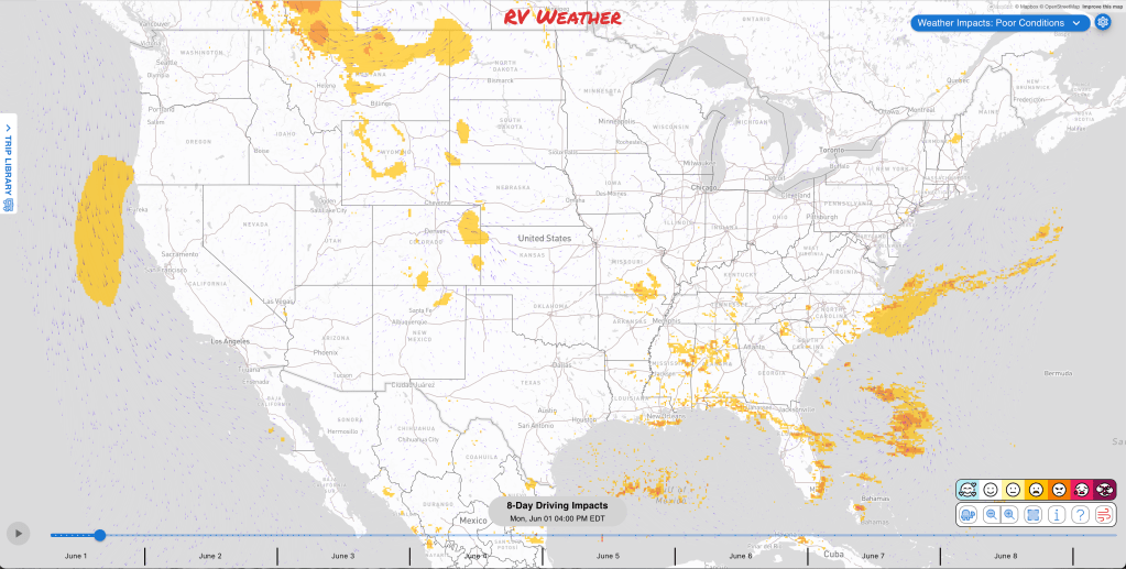
Significant travel weather for the next 2-3 days.
NEW: Extended forecast for the next 2 weeks now included!
Weather Impacts Pacific:
— No significant weather impacts to RV Weather today or Tuesday.
Weather Impacts Mountain:
— Northwestern Montana: Flood Warnings and Flood Watches through early evening for south-central Flathead County, western Lake County, and small streams along the Mission and Swan mountain ranges, where 1 to 3 inches of rain have fallen and another 1 to 2 inches is possible. Flooding of creeks, streams, and low-lying roads may create high water in flood-prone areas. US-93 impacted.
— East Glacier Park Region, Montana: Snow in Glacier Park, with snow levels near 6000 feet this morning rising toward 7000 feet later today and 5 to 10 inches of new snow possible above 6000 feet. Higher-elevation travel may become winter-like with slower travel over exposed terrain. US-2, US-89 impacted.
— Missoula County, Montana: Flood Watch through Wednesday for the Clark Fork River above Missoula, where flooding of low-lying areas and nearby streets is possible if the river reaches flood stage. I-90, US-12, US-93 potentially impacted.
— Southeast Montana, eastern Wyoming and much of eastern Colorado: Severe thunderstorms are expected this afternoon and evening, with large hail and severe wind gusts the main travel hazards. The greatest risk of severe weather will be across northeastern Colorado. I-25, I-70, I-76, I-80, I-90, US-6, US-14, US-16, US-18, US-20, US-24, US-26, US-30, US-34, US-36, US-40, US-50, US-56, US-85, US-160, US-212, US-285, US-287, US-385, US-400 potentially impacted.
— Eastern Montana, eastern Wyoming, eastern Colorado, and northeastern and east-central New Mexico: A few severe storms are expected Tuesday afternoon and evening, with hail and strong wind gusts the main concerns. I-25, I-40, I-70, I-76, I-80, I-90, I-94 potentially impacted.
— Eastern Colorado: Isolated severe thunderstorms are possible Wednesday afternoon and evening, with hail and strong wind gusts possible. I-70, I-76, I-80, US-6, US-24, US-30, US-34, US-36, US-40, US-50, US-56, US-160, US-287, US-385, US-400 potentially impacted.
— Eastern New Mexico: Flash flooding is possible Tuesday into early Wednesday as another round of storms spreads east, with pockets of 1 to 2 inches of rain possible and isolated to scattered flash flooding most likely near burn scars and steeper terrain. Low-water crossings and normally dry washes may become unsafe. I-25, I-40, US-54, US-60, US-62, US-70, US-82, US-84, US-180, US-285, US-380 potentially impacted.
Weather Impacts Central:
— Eastern Kansas Coffey and Lyon Counties: FLOOD WARNING through late morning, where 2 to 5 inches of rain have fallen. High water in low-lying areas may slow or block travel. I-35, US-50 likely impacted.
— West-central Missouri Kansas City metro area: FLASH FLOOD WARNING this morning for Wyandotte County, Kansas, and Clay and Platte Counties, Missouri, where 2 to 3 inches of rain have fallen. Low spots and urban drainage areas may flood quickly. I-29, I-35 impacted.
— Central Missouri Boone County: FLASH FLOOD WARNING this morning, where 2 to 3 inches of rain have fallen and another 1 to 2 inches is possible. Avoid low-water crossings and be prepared for water-covered roads. I-70, US-63 impacted.
— East-central Missouri and southwest Illinois: Severe Thunderstorm Watch through late morning, with severe storms possible across the St. Louis region and nearby counties. Damaging wind, hail, torrential rain, and sudden visibility reductions may affect travel. I-44, I-55, I-64, I-70, US-67 potentially impacted.
— Parts of South Dakota, southwestern Minnesota , western Iowa, Nebraska, Kansas, much of Missouri, southeast Illinois, northern Oklahoma, much of Arkansas, western Kentucky, and much of Tennessee, Mississippi, and Alabama: Severe thunderstorms are expected this afternoon and evening, with large hail and severe wind gusts in the central Plains and scattered strong to severe wind gusts from the Ozarks into the Southeast. The greatest risks of severe weather will be across western and central Nebraska and Kansas. Also across northeastern Arkansas, central and western Tennessee, northeastern Mississippi, and northwestern Alabama. I-20, I-22, I-24, I-29, I-30, I-35, I-40, I-44, I-49, I-55, I-57, I-59, I-64, I-65, I-69, I-70, I-75, I-76, I-80, I-85, I-90 potentially impacted.
— North Dakota, most of South Dakota, central and western Nebraska, western Kansas, Oklahoma and Texas Panhandles: Severe thunderstorms are expected Tuesday afternoon and evening, with large hail, severe wind gusts, and an isolated tornado threat in the northern Plains, plus strong wind gusts and hail possible farther south. The greatest risk of severe weather will be across parts of the Dakotas. I-27, I-29, I-40, I-70, I-76, I-80, I-90, I-94 potentially impacted.
— Eastern North Dakota and western Minnesota, much of South Dakota, much of central and western Nebraska, western Kansas, and the Oklahoma Panhandle: Severe thunderstorms are possible Wednesday afternoon and evening, with large hail and severe wind gusts possible in the northern and central Plains. The greatest risk of severe weather will be across eastern North Dakota and adjacent northwestern Minnesota, and northeastern South Dakota. I-29, I-70, I-76, I-80, I-90, I-94 potentially impacted.
— Western Texas: Flash flooding is possible Tuesday into early Wednesday as storms may produce pockets of 1 to 2 inches of rain, with isolated to scattered flash flooding possible where heavier storms repeat. Low-water crossings, poor-drainage areas, and burn-scar or steeper terrain locations may become hazardous. I-10, I-20, I-40, US-60, US-62, US-67, US-70, US-82, US-84, US-90, US-180, US-285, US-380, US-385 potentially impacted.
— Western Texas and adjacent southeast New Mexico: Flash flooding is possible Wednesday into early Thursday as a stronger disturbance may support robust storms over western Texas, especially near the Texas Panhandle, with isolated to scattered flash flooding possible and some rain falling over areas affected Tuesday. I-10, I-20, I-27, I-40, US-60, US-62, US-67, US-70, US-82, US-83, US-84, US-87, US-90, US-180, US-190, US-285, US-287, US-380, US-385 potentially impacted.
Weather Impacts Eastern:
— Southern-tier New York valleys: Valley fog this morning with visibility down near one-quarter mile. Expect reduced visibility and slower travel in low-lying areas. I-81, I-86, I-88, I-90, US-11, US-20, NY-17 impacted.
— Maryland Chesapeake shorelines: Coastal Flood Advisories through midday for Anne Arundel County, Southern Baltimore County, Baltimore City, and Southeast Harford, with up to one foot of inundation in Anne Arundel low-lying areas, up to one half foot in Southern Baltimore and Baltimore City low-lying areas.
— Most of Tennessee, northern Georgia, and Upstate South Carolina: Severe thunderstorms are possible Monday afternoon and evening, accompanied by scattered strong to severe wind gusts. I-20, I-24, I-26, I-40, I-59, I-75, I-77, I-85 potentially impacted.
— Southern Georgia, northern Florida, eastern Florida Peninsula: A few severe storms are possible Tuesday afternoon and evening, with severe wind gusts possible. I-4, I-10, I-75, I-95, US-1, US-17, US-19, US-23, US-25, US-27, US-41, US-84, US-98, US-301, FL-A1A potentially impacted.
Outlook Wednesday June 3rd through Sunday June 7th:
— Wednesday, June 3 through Thursday, June 4: portions of eastern New Mexico, western Oklahoma, and westernTexas: Heavy rain may create localized flooding and reduced visibility. Major highways potentially affected include I-10, I-20, I-40.
Extended Outlook June 8th through 14th:
— Monday, June 8 through Thursday, June 11: from Montana and Wyoming across the northern and central Plains into the Upper Midwest, Great Lakes, Ohio Valley to western Pennsylvania: Extreme heat may develop, which could create challenging conditions. Major highways potentially affected include I-25, I-29, I-35, I-55, I-64, I-65, I-70, I-71, I-74, I-75, I-76, I-79, I-80, I-90, I-94.
— Monday, June 8 through Friday, June 12: most of the Florida Peninsula: Heavy rain may develop, which could create localized flooding and reduced visibility. Major highways potentially affected include I-4, I-75, I-95.
Forecast Confidence for the Extended Outlook:
Confidence is generally better for the earlier part of the outlook, with good large-scale agreement on the overall pattern. Confidence decreases later in the outlook because signals become more mixed, especially for precipitation, and ensemble spread increases.
Looking for real-time road conditions? Here’s a link, courtesy of the Federal Highway Administration, to all the individual State 511 websites.
Your route’s weather may vary from the general forecast — check your exact trip
48-hour access • No credit card required
Risk free – 30-day money-back guarantee
Selected travel-relevant Weather Graphics


Graphics for Today


Current Severe Thunderstorm and Tornado Watches from the National Weather Service Storm Prediction Center


Hail Size Forecast for today and tomorrow

Wildfire Smoke Forecast for today and tomorrow

Graphics for Tomorrow


National Weather Map for the Day after Tomorrow

Three-day Summaries


Day 3 – Day 7 U.S. Significant Weather Outlook

Access to real-time road information:
Phone numbers and websites for road conditions in all 50 states. Courtesy of the Cheyenne WY Weather Forecast Office
Some useful links:
Thank you for using RVWeather.