
- Thunderstorms and strong winds increase the fire weather risk across parts of the Inter-mountain West and northern High Plains today.
- Heavy rains and some flooding continue today across parts of central Texas and the southern Texas coast.
- Late season heat wave for much of California and the desert Southwest Wednesday through Friday.
From the RV Weather Field Headquarters in State College PA:
These are the most significant weather impacts to RV travel over the next two to three days. I do not list every area of rain, showers, or breezy winds. It would be exhausting (for both of us!).
Weather Impacts Pacific Time Zone:
— Southwest OR; CA Sacramento and San Joaquin Valleys; Much of the central CA coast and coastal ranges: Heat Advisories Wednesday through Friday. Temperatures will range from the mid-90’s to 107 deg F.
— Much of southern CA; southern NV: Excessive Heat Warnings and Watches Wednesday through Friday. High temperatures will range from 102-107 deg F in the southern San Joaquin Valley to 107-120 deg in the southeast CA deserts, including Death Valley NP. Thursday is expected to be the hottest day of the week.
Weather Impacts Mountain Time Zone:
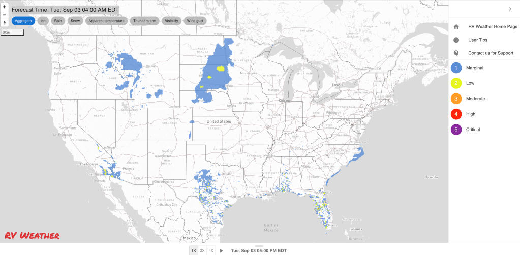
— Much of east-central and southeast ID; northwest UT: Red Flag (fire danger) Warnings today and this evening for scattered thunderstorms and associated lightning. Outflow wind gusts from thunderstorms may reach 45 mph. I-15, I-80, I-84, I-86, US-26, US-30, US-93 impacted.
— Southern MT; east-central ID; WY; northern UT: Thunderstorms this afternoon will be capable of producing a few locally severe wind gusts and some hail. I-15, I-25, I-80, I-90, I-94 potentially impacted.
— Central, south-central and southeast MT; central and eastern WY; northern and central CO: Isolated strong to severe thunderstorms are possible on Wednesday. Damaging wind gusts and hail will be the primary hazards. I-25, I-70, I-76, I-80, I-90, I-94 potentially impacted.
— Much of eastern WY: Red Flag (fire danger) Warning this afternoon and evening. Wind gusts to 35 mph. I-25, I-90, US-16, US-18, US-20, US-26 impacted.
— Most of western, central, south-central and southwest AZ: Excessive Heat Warnings and Watches Wednesday through Friday. High temperatures 106-115 deg F will be common.
Weather Impacts Central Time Zone:
— Northwest ND: Dense Fog Advisory through mid-morning. US-85 impacted.
— Southeast ND and adjacent northwest MN; central and eastern SD; north-central NE: Strong winds continue through Wednesday morning. Wind gusts 35-45 mph. I-80, I-90, I-94, US-2, US-12, US-14, US-18, US-20, US-81, US-83, US-281 impacted.
— Western SD; northwest NE: Red Flag (fire danger) Warnings through this evening. Wind gusts to 35 mph. I-80, I-90, US-16, US-18, US-20, US-26, US-85, US-212, US-385 impacted.
— Western SD: Thunderstorms this afternoon will be capable of producing a few locally severe wind gusts. I-90, US-85 potentially impacted.
— Central, southern and eastern ND; southwest, central and northern MN; SD; northern, central and western NE: Isolated strong to severe thunderstorms are possible on Wednesday. Damaging wind gusts and hail will be the primary hazards. I-29, I-35, I-80, I-90, I-94 potentially impacted.
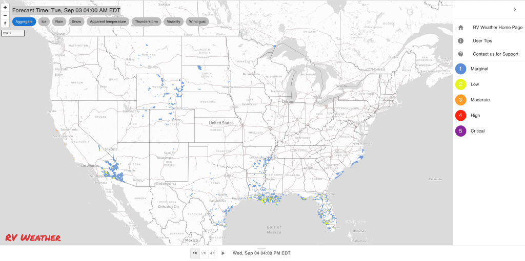
— Central TX: Flood Watches and Advisories continue through this evening. An additional 1-2 inches of rainfall is possible today in addition to the widespread 2-4 inches of rain that have already fallen. Some locations have seen up to 7 inches of rain. Localized flash flooding probable. This region is bounded by I-10 to the south and I-20 to the north. I-10, I-20, I-27, US-67, US-82, US-83, US-84, US-87 impacted.
— Central and southern TX Coast: Heavy rain showers and thunderstorms continue today and Wednesday. Some areas could see an additional 4 inches of rain. I-10, I-37, I-69E, US-77 impacted.
Weather Impacts Eastern Time Zone:
— Coastal NC; coastal SC: Strong on-shore winds today and tonight. Strong build down along the coast from Cape Hatteras to Savannah GA. Wind gusts 30-35 mph. US-17, US-64 impacted.
— Coastal NC: Strong to marginally severe thunderstorms possible Thursday afternoon. US-17, US-64, US-70 potentially impacted.
Graphics for Today


Current Severe Thunderstorm and Tornado Watches from the National Weather Service Storm Prediction Center


Graphics for Tomorrow


Three-day Summaries


Access to real-time road information:
Phone numbers and websites for road conditions in all 50 states. Courtesy of the Cheyenne WY Weather Forecast Office
Some useful links:
Thank you for using RVWeather.