
- Tropical Storm Francine will likely form today southeast of Brownsville Texas. The storm will move north, then northeast and likely make landfall as a hurricane along the Louisiana coast on Wednesday.
- RV’ers traveling along I-10 and I-20 through from Biloxi to Houston or Jackson to Shreveport midweek, should expect their travel plans to be disrupted. Flooding rains may move into the Mid-South Thursday and Friday.
- The late season heat wave and high wildfire danger for southwest California continue today. Much cooler temperatures for the West starting mid-week.
From the RV Weather Field Headquarters in State College PA:
These are the most significant weather impacts to RV travel over the next two to three days. I do not list every area of rain, showers, or breezy winds. It would be exhausting (for both of us!).
Weather Impacts Pacific Time Zone:
— East-central and southeast WA: Red Flag Warning this afternoon and evening. Wind gusts to 30 mph. I-90, US-2, US-12, US-195 impacted.
— Much of southwest CA: Heat Advisories along the Coast and Excessive Heat Warnings Inland through this evening. Temperatures will range from around 90 deg on the coast to 100-114 deg F inland.
— Southern CA western Santa Ynez Range and Santa Barbara County Coast: Red Flag Warnings through late this evening. Hot and very dry conditions. Localized wind gusts to 40 mph at night. US-101, CA-1 impacted.
— CA/AZ Border Colorado Valley: Excessive Heat Warning through Tuesday evening. Afternoon temperatures 109-113 deg F.
Weather Impacts Mountain Time Zone:
— Northwest MT Rocky Mountain Front; south-central and portions of southeast MT; much of northern, central and eastern WY: Red Flag (fire danger) Warnings this afternoon and evening. Wind gusts 30-35 mph. I-25, I-90, I-94, US-2, US-14, US-16, US-18, US-20, US-26, US-87, US-89, US-191, US-212, US-310 impacted.
— CA/AZ Border Colorado Valley: Excessive Heat Warning through Tuesday evening. Afternoon temperatures 109-113 deg F.
Weather Impacts Central Time Zone:
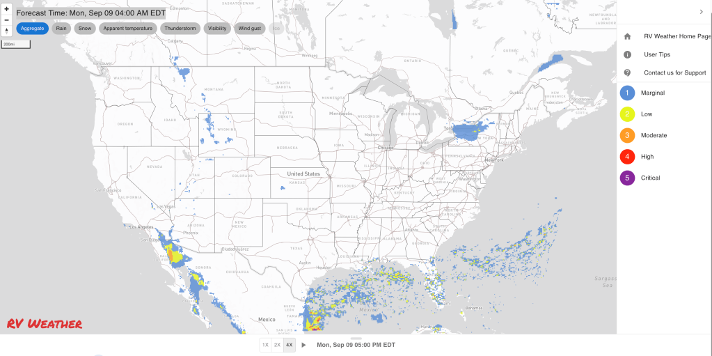
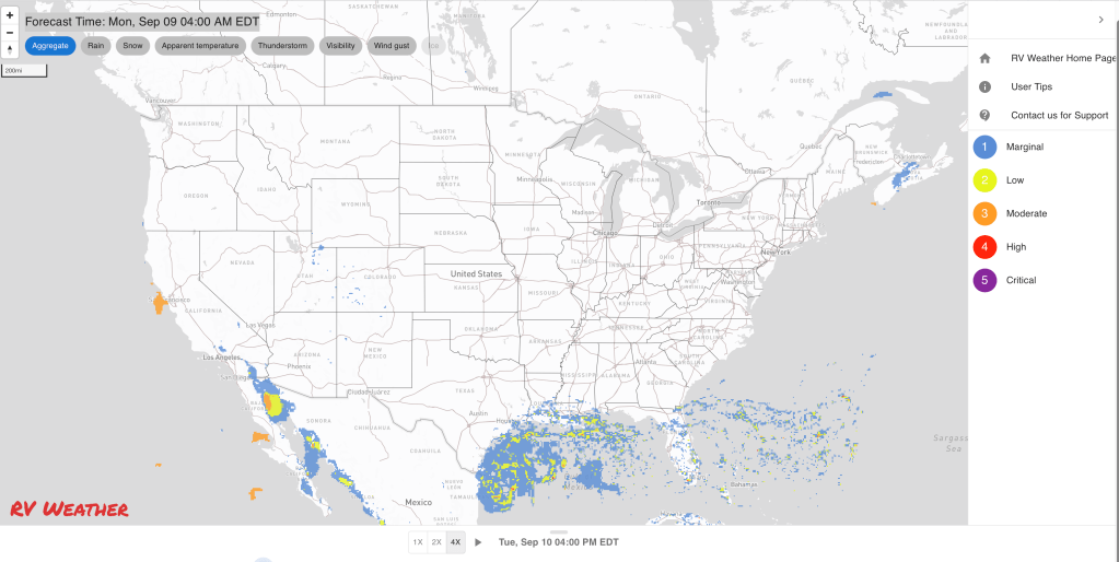
— TX coast, coastal LA; coastal MS: Tropical storm Francine is expected to form today to the southeast of Brownsville TX. The storm will move north, then northeast, intensify, and make landfall somewhere along the LA coast Wednesday, probably as a hurricane. Heavy, flooding rains, strong winds and a storm surge of at least 3-6 feet can all be expected. I expect the National Hurricane Center will issue tropical storm and hurricane Watches later today for portions of the Gulf Coast between Galveston TX and Biloxi MS. If you are planning to travel through or stay along the Upper TX coast or I-10 from Biloxi MS to Houston mid-week, your travel plans will likely need to be changed.
— Far-southern TX Coast: Strong winds continue today. Wind gusts 30-35 mph. I-2, I-69E, US-77 impacted.
— Far-southern TX Coast: Flood Watch through Wednesday. Rainfall associated with Potential Tropical Cyclone Six (soon-to-be Francine) will cause localized flash flooding. 3-6 inches of rainfall is possible by Wednesday morning with isolated areas seeing up to 8 inches of rain. I-2, I-69E, US-77 potentially impacted.
— Southeast LA; southern MS; southwest AL; western FL Panhandle: Isolated tornados are possible Wednesday and Wednesday night, associated with Francine’s landfall. I-10, I-12, I-49, I-55, I-59, I-65 potentially impacted.
— Much of MS; western and northern AL; western TN and KY: There is the potential for heavy, flooding rains Thursday and Friday, associated with the remnants of Francine after it makes landfall and moves northwards. I-10, I-20, I-22, I-24, I-40, I-55, I-59, I-65 potentially impacted.
Weather Impacts Eastern Time Zone:
— Much of Upstate NY except northern Adirondack Mountains: Some strong to marginally severe thunderstorms possible today. Damaging wind gusts are the primary hazard. I-81, I-86, I-87, I-88, I-90, US-20, NY Thruway potentially impacted.
— Southern FL: Heat Advisory today. Heat index values may reach 108 deg F.
Graphics for Today


Current Severe Thunderstorm and Tornado Watches from the National Weather Service Storm Prediction Center


Graphics for Tomorrow


Three-day Summaries


Access to real-time road information:
Phone numbers and websites for road conditions in all 50 states. Courtesy of the Cheyenne WY Weather Forecast Office
Some useful links:
Thank you for using RVWeather.