


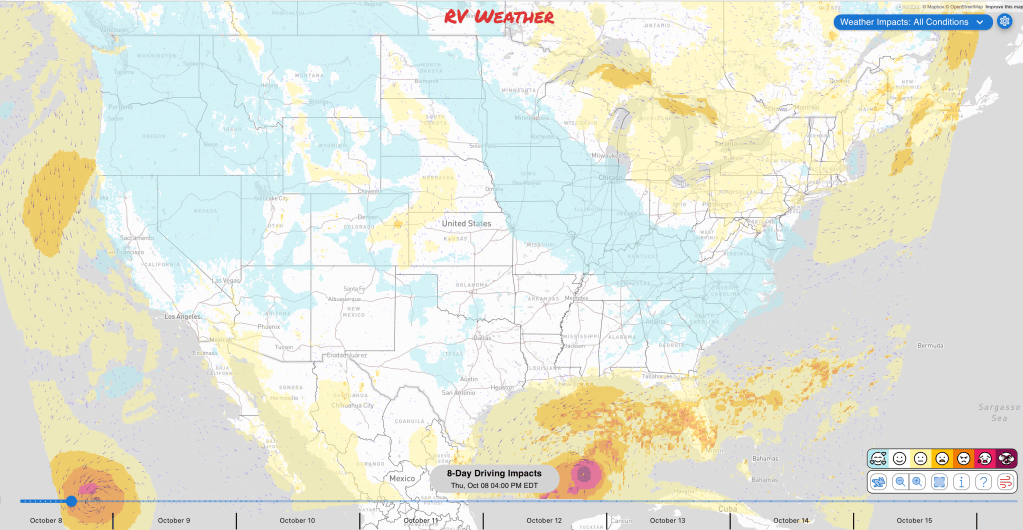
Planning to travel this week? Here’s what could impact your route.
- Hurricane Isaias threatens the northern Gulf Coast Friday into Saturday: anticipate 4–7 feet of surge and wind gusts to 110 mph, with significant flash flooding and tornadoes possible inland.
- Tropical Storm Rachel may bring strong winds, heavy rain, coastal flooding and dangerous surf to Southern California and the Southwest this weekend into early next week.
- Heat grips much of California and southwestern Arizona today.
Your route’s weather may vary from the general forecast — check your exact trip
This free daily forecast is separate from a paid RV Weather SureRoute subscription. SureRoute checks the weather along your specific route and travel timing.
48-hour access • No credit card required
Risk-free · 30-day money-back guarantee
Significant travel weather for the next 2-3 days.
Weather Impacts Pacific:
— California’s North Coast, northern and central California, the Bay Area, and California’s Central Coast, including the Sacramento and San Joaquin valleys, Sierra foothills, Santa Lucia Mountains and Santa Ynez Valley: Heat Advisories remain in effect today. Coastal highs range from 80 to 95°F, while inland valleys, foothills and mountains reach 92 to 105°F; warm overnight temperatures will provide limited relief in some foothill and inland areas.
— Southern California and the California Deserts, plus southwestern and west-central Arizona, including the Cuyama Valley, Los Angeles Basin, Inland Empire, San Diego and Orange coastal and inland areas, Imperial and Coachella valleys, Death Valley, the Parker, Gila, Palo Verde and Chuckwalla valleys: Extreme Heat Warnings cover the region today, with coastal and mountain locations generally in the mid-80s to near 100°F and valleys reaching 103 to 106°F. Warnings continue through Friday in the Imperial and Coachella valleys and Death Valley, where highs reach 104 to 111°F. Routes potentially affected: I-5, I-8, I-10, I-15, US-60, US-95, US-101, CA-1, CA-2, CA-14, CA-18, CA-62, CA-78, CA-86, CA-168.
— California’s Bay Area, Central Coast and Southern California coast, including San Pablo, San Francisco and Monterey bays, Big Sur, Malibu, Catalina and Santa Barbara islands, the San Diego and Orange coastal areas: Coastal Flood Advisories affect the California coast. Up to 1.2 feet of inundation may flood low roads and shoreline areas around San Pablo Bay through Wednesday and San Francisco and Monterey bays Friday through Tuesday; Southern California has minor to locally moderate flooding, erosion, elevated surf and dangerous rip currents through Tuesday, with the highest flood risk Sunday.
Weather Impacts Mountain:
— A small portion of southwestern Arizona, including Yuma: An Extreme Heat Warning continues through Friday evening, with afternoon temperatures of 103 to 107°F. Routes potentially affected: I-8, US-95.
Weather Impacts Central:
— Much of Tennessee, northeastern and east-central Arkansas, northern Mississippi, northern, central and eastern Alabama, and the Florida Panhandle: Flash flooding is possible across this corridor Saturday, with flash flooding possible as Isaias moves inland. Routes potentially affected: I-10, I-20, I-22, I-24, I-40, I-55, I-59, I-65, I-69, I-85.
— East-central and southeastern Louisiana, including Slidell, Lake Catherine, the Lake Pontchartrain shore and the western New Orleans area: Tropical Storm Warnings and Storm Surge Warnings are in effect. Winds of 20 to 30 mph may gust to 40 or 45 mph, while life-threatening surge of 3 to 5 feet is possible Friday morning through Saturday morning, weakening or washing out low coastal roads. A Coastal Flood Advisory farther west calls for 1 to 3 feet of water over normally dry ground Friday and Saturday. Routes potentially affected: I-10, I-12, US-90, US-190.
— The Mississippi Coast and southeastern Mississippi, including Bay St. Louis, Gulfport, Biloxi, Ocean Springs, Pascagoula, Moss Point and nearby inland communities: A HURRICANE WARNING covers the eastern Mississippi Coast, while Tropical Storm Warnings, Storm Surge Warnings and inland Tropical Storm Watches cover surrounding areas. Surge may reach 4 to 7 feet near Pascagoula and 3 to 5 feet farther west Friday into Saturday; forecast gusts range from 35 to 50 mph, with 3 to 6 inches of rain and locally higher amounts in the east. Routes potentially affected: I-10, US-49, US-98.
— Eastern Mississippi, much of Alabama, the Florida Panhandle and southwestern Georgia: Flood Watches cover southwestern, south-central and southeastern Alabama, the Florida Panhandle and southwestern Georgia Friday through Saturday. Rainfall of 3 to 7 inches with localized totals near 10 inches may cause considerable flash flooding in southeastern Alabama, the Panhandle and southwestern Georgia; a significant flash-flood threat is embedded Friday within eastern Mississippi, most of Alabama and the Florida Panhandle. Routes potentially affected: I-10, I-20, I-22, I-59, I-65, I-85.
— Southwestern Alabama, including Mobile, Daphne, Fairhope, Foley, Bay Minette and the Mobile Bay shore: HURRICANE WARNINGS cover southwestern Alabama, with Storm Surge Warnings along Mobile Bay. Winds arrive Friday afternoon into early Saturday; gusts may reach 70 mph near the eastern bay shore and 40 to 45 mph around Mobile and inland. Coastal surge may reach 4 to 7 feet, while 3 to 6 inches of rain, tornadoes, fallen trees and widespread outages are possible. Routes potentially affected: I-10, I-65, US-43.
— Southwestern, south-central, central and southeastern Alabama: Hurricane Watches cover parts of south-central and southwestern Alabama, while Tropical Storm Watches extend across the surrounding inland region. Friday-night gusts may reach 70 to 80 mph in the hurricane-watch area and 30 to 60 mph elsewhere; rainfall of 2 to 6 inches with locally higher amounts, flooding, fallen trees and several tornadoes are possible. Routes potentially affected: I-65, US-29, US-43, US-84, US-231, US-431.
— Southern, north-central and eastern Alabama and the Florida Panhandle: A severe-weather threat develops Friday night across southern Alabama and the Florida Panhandle, with tornadoes possible as Isaias approaches. Saturday, the severe and tornado threat shifts north across north-central and eastern Alabama while continuing over the Florida Panhandle. Routes potentially affected: I-10, I-20, I-22, I-59, I-65, I-85.
— The western Florida Panhandle, including Pensacola, Gulf Breeze, Navarre, Milton, Destin, Fort Walton Beach, Crestview and De Funiak Springs: HURRICANE WARNINGS and Storm Surge Warnings cover the western Florida Panhandle coast and adjacent inland areas; Hurricane Watches and Tropical Storm Warnings extend into the Walton area. Friday into early Saturday, coastal and nearby inland gusts may reach 65 to 110 mph with 4 to 7 feet of surge, while farther east and inland gusts of 40 to 45 mph accompany 3 to 6 inches of rain. A Flood Watch is also in effect Friday and Saturday. Routes potentially affected: I-10, US-98.
— The Florida Panhandle and northwestern Florida, including South Walton, Panama City, Mexico Beach, Saint Marks, Panacea, Marianna and nearby inland areas: HURRICANE WARNINGS and Storm Surge Warnings cover the South Walton and Panama City coast, while Storm Surge Warnings continue eastward and Tropical Storm Warnings cover adjacent inland areas. Friday into Saturday, coastal gusts reach 55 to 70 mph with 4 to 7 feet of surge; farther east, surge reaches 4 to 6 feet, while inland gusts of 30 to 45 mph accompany 2 to 6 inches of rain. Routes potentially affected: I-10, US-98, US-231.
Weather Impacts East:
— East Tennessee, a portion of Southwest Virginia and a small portion of western North Carolina: Patchy fog in sheltered river valleys may become locally dense this morning, reducing visibility to one-quarter mile or less before improving an hour or two after sunrise. Routes potentially affected: I-24, I-26, I-40, I-75, I-81, US-19, US-25E, US-27, US-58, US-64, US-70, US-74, US-127.
— Middle and East Tennessee, western and southern North Carolina, South Carolina, most of Georgia, and the northwestern Florida Peninsula edge: Flash flooding is possible across this corridor Saturday, with flash flooding possible as Isaias and its tropical moisture move inland. Routes potentially affected: I-10, I-20, I-40, I-74, I-75, I-85, I-95.
— Eastern North Carolina, Lowcountry South Carolina, a small portion of southeastern Georgia and northeastern Florida, including Wilmington and the lower Cape Fear River, Charleston and the Atlantic beaches: Coastal Flood Advisories cover these areas today. Up to one-half foot of inundation may put water onto low roads near Wilmington and Charleston this morning, while minor flooding continues along the Georgia and northeastern Florida beaches through afternoon; dangerous rip currents there persist through late Saturday.
— Southeastern North Carolina, much of South Carolina, Georgia and the northern Florida Peninsula: Severe thunderstorms may spread north across this corridor Saturday as Isaias moves inland. A severe-weather threat focuses on southwestern Georgia, where the greatest severe-weather risk is forecast; tornadoes are possible within the broader tropical rain-band threat. Routes potentially affected: I-10, I-16, I-20, I-24, I-26, I-40, I-59, I-75, I-77, I-85, I-95.
— Southwestern Georgia and the northwestern Florida Peninsula: A severe-weather threat develops Friday night, with tornadoes possible as tropical rain bands move inland. Routes potentially affected: I-10, US-19, US-27, US-84, US-98.
— Western Georgia and the northwestern Florida Peninsula: A significant flash-flood threat is embedded within this area Friday, with flash flooding possible as tropical rain bands repeatedly cross the region. Routes potentially affected: I-10, I-20, I-75, I-85, US-19, US-23, US-27, US-29, US-78, US-80, US-82, US-84, US-98, US-278, US-280, US-431.
— The eastern Florida Panhandle and northwestern Florida coast, including Port Saint Joe, Cape San Blas, Apalachicola, Carrabelle, Keaton Beach and Steinhatchee: Storm Surge Warnings and Tropical Storm Warnings cover the eastern Panhandle coast, with a Storm Surge Warning continuing southeastward. Friday into Saturday, surge may reach 4 to 7 feet near Port Saint Joe and 4 to 6 feet from Apalachicola through Steinhatchee; gusts reach 30 to 50 mph, with an additional 1 to 6 inches of rain depending on location. Routes potentially affected: US-98.
— A small portion of northwestern Florida, including Cedar Key, Yankeetown and Fowler Bluff: A Storm Surge Watch is in effect for Friday morning through Saturday morning, with life-threatening inundation of 2 to 4 feet possible. Additional rainfall of 2 to 4 inches may cause localized flooding. Routes potentially affected: US-19, US-98.
— A small portion of northwestern Florida along the Withlacoochee River at Dunnellon: A Flood Warning continues until further notice. Minor flooding is occurring and forecast, with the river expected to crest near 28.6 feet early today; docks and boat ramps are flooded along the river. Routes potentially affected: US-41.
— A small portion of northeastern Florida, including the St. Johns River Basin, Trout River and Jacksonville coast: A Coastal Flood Warning remains in effect in the St. Johns River Basin until late afternoon, with significant flooding that may close numerous roads and inundate low-lying property. Coastal Flood Advisories then continue in the basin, along the Trout River and Jacksonville coast through Saturday afternoon, with minor flooding and isolated road closures. Routes potentially affected: I-95, US-1, US-17.
— West-central Florida, including the coast from Yankeetown to Egmont Key and nearby inland areas: A Flood Watch is in effect today, with 1 to 3 inches of rain and localized totals above 5 inches capable of flooding urban, low-lying and poor-drainage areas. A Coastal Flood Advisory follows Friday into Saturday morning as tides rise 1 to 3 feet above astronomical levels. Routes potentially affected: I-4, I-75, US-19, US-41, US-98, US-301.
Tropical Weather Outlook for the next 7 days:
— Hurricane Isaias, 420 miles south-southwest of the Mouth of the Mississippi River: Isaias has 80 mph winds and is moving east-northeast at 9 mph. It is forecast to strengthen before approaching the northern Gulf Coast Friday night, bringing dangerous wind, 3 to 7 inches of rain with localized 10-inch totals, tornadoes and life-threatening storm surge.
— Tropical Storm Rachel, 900 miles west of the southern tip of Baja California: Rachel has 70 mph winds and is moving west-northwest at 8 mph. A turn northeast is forecast as the storm weakens, with strong winds, coastal flooding, heavy rain and dangerous surf possible in Southern California and the Southwest this weekend into early next week.
— Tropical Storm Simon, 190 miles south-southwest of Lazaro Cardenas, Mexico: Simon has 50 mph winds and is forecast to rapidly strengthen into a major hurricane before approaching southwestern Mexico Saturday. Rainfall of 8 to 12 inches, with isolated totals of 15 to 25 inches, may cause life-threatening flooding and mudslides there; no U.S. impacts are indicated.
Extended Hazard Outlook
Outlook Saturday, October 10th through Tuesday, October 13th:
— Saturday, October 10 through Sunday, October 11: Western Montana and northwestern Wyoming: Heavy snow may create difficult travel over higher terrain and mountain passes. Major highways potentially affected include I-15, I-90.
— Saturday, October 10: From the mid-Mississippi and lower Ohio valleys through Tennessee, Mississippi, Alabama and the Southeast into southern Virginia: Heavy rain may create localized flooding and difficult travel. Major highways potentially affected include I-10, I-20, I-40, I-55, I-64, I-65, I-71, I-74, I-75, I-81, I-85, I-87, I-95.
— Saturday, October 10: Mississippi, Alabama, northwestern Florida and southwestern Georgia: High winds may create hazardous crosswinds for high-profile vehicles. Major highways potentially affected include I-10, I-20, I-65, I-85.
— Saturday, October 10: Southeastern Mississippi, much of Alabama and northwestern Florida: Severe weather may create rapidly changing and hazardous travel conditions. Major highways potentially affected include I-10, I-65, I-85.
— Sunday, October 11 through Monday, October 12: From much of California across the Great Basin and Arizona into parts of the Rockies and northwestern New Mexico: Heavy rain may create localized flooding and difficult travel. Major highways potentially affected include I-5, I-8, I-10, I-15, I-40, I-70, I-80, I-84.
— Sunday, October 11: Southeastern California, Arizona and nearby portions of Nevada, Utah and southwestern New Mexico: High winds may create hazardous crosswinds for high-profile vehicles, especially near Continental Divide, New Mexico. Major highways potentially affected include I-8, I-10, I-40.
— Sunday, October 11: From northeastern North Carolina and Virginia through the Mid-Atlantic into southeastern New York and southern New England: Heavy rain may create localized flooding and difficult travel. Major highways potentially affected include I-64, I-70, I-76, I-80, I-81, I-84, I-87, I-91, I-95.
— Monday, October 12 through Tuesday, October 13: Washington, northern Oregon and northwestern Idaho: Frost or freeze concerns may create challenging conditions for early-season RVers. Major highways potentially affected include I-84, I-90.
— Monday, October 12 through Tuesday, October 13: From Montana and Wyoming across the Dakotas into northwestern Nebraska: Frost or freeze concerns may create challenging conditions for early-season RVers. Major highways potentially affected include I-25, I-90, I-94.
— Tuesday, October 13: From the eastern Great Basin and Southwest through the central Rockies into western Texas: Heavy rain may create localized flooding and difficult travel. Major highways potentially affected include I-8, I-10, I-15, I-25, I-40, I-70, I-80, I-84.
Extended Outlook Thursday, October 15th through Saturday, October 17th:
— Thursday, October 15 through Saturday, October 17: From southeastern New Mexico and the southern Plains through the mid- and lower Mississippi and Tennessee valleys into Alabama: Heavy precipitation may develop, creating localized flooding and difficult travel. Major highways potentially affected include I-10, I-20, I-30, I-35, I-40, I-55, I-65.
— Thursday, October 15 through Friday, October 16: New York and New England: Much below normal temperatures may develop, creating cold-weather travel concerns. Major highways potentially affected include I-81, I-84, I-87, I-90, I-91, I-95.
Confidence in the Extended Outlook:
Confidence is relatively good for the earlier period because of broad agreement on the large-scale pattern, though uncertainty remains around the timing and strength of smaller-scale features. Confidence is about average later, with fairly good agreement on the overall pattern but differences in temperature and precipitation details.
Looking for real-time road conditions? Here’s a link, courtesy of the Federal Highway Administration, to all the individual State 511 websites.
Your route’s weather may vary from the general forecast — check your exact trip
48-hour access • No credit card required
Risk-free · 30-day money-back guarantee
Weather Maps and National Outlooks
For current NWS hazards, severe-storm and hurricane outlooks, heavy-rain risk, wind, smoke, heat/winter risk, and other always-updating weather graphics, visit:
Access to real-time road information:
Phone numbers and websites for road conditions in all 50 states. Courtesy of the Cheyenne WY Weather Forecast Office
Some useful links:
Thank you for using RVWeather.